
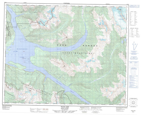
083D01 Wood Arm Canada topo map, 1:50,000 scale
083D01 Wood Arm NRCAN topographic map.
Includes UTM and GPS geographic coordinates (latitude and longitude). This 50k scale map is suitable for hiking, camping, and exploring, or you could frame it as a wall map.
Printed on-demand using high resolution, on heavy weight and acid free paper, or as an upgrade on a variety of synthetic materials.
Topos available on paper, Waterproof, Poly, or Tyvek. Usually shipping rolled, unless combined with other folded maps in one order.
- Product Number: NRCAN-083D01
- Parent Topo: TOPO-083D
- Map ID also known as: 083D01, 83D1, 83D01
- Unfolded Size: Approximately 26" high by 36" wide
- Weight (paper map): ca. 55 grams
- Map Type: POD NRCAN Topographic Map
- Map Scale: 1:50,000
- Geographical region: British Columbia, Canada
Neighboring Maps:
All neighboring Canadian topo maps are available for sale online at 1:50,000 scale.
Purchase the smaller scale map covering this area: Topo-083D
Spatial coverage:
Topo map sheet 083D01 Wood Arm covers the following places:
- Cummins Arm - Harvey Bay - Molson Bay - Redrock Harbour - Sprague Bay - Wood Arm - Yellow Bay - Clemenceau Icefield - Cummins Glacier - Cummins Lakes - Kinbasket Lake - McNaughton Lake - Big Bend Ranges - Columbia Mountains - Fred Laing Ridge - Montagnes Rocheuses - Mount Cummins - Mount Dainard - Mount Molson - Mount Morrison - Mount Sharp - Park Ranges - Reconnaissance Ridge - Rocky Mountains - Selkirk Mountains - Warsaw Mountain - Columbia-Shuswap Regional District - Regional District of Fraser-Fort George - Cummins Lakes Park - Boulder Rapids - Mink Rapids - Redrock Canyon Rapids - Weasel Rapids - Yellow Creek Rapids - Bobcat Creek - Columbia River - Cummins River - Dainard Creek - Encampment Creek - Fleuve Columbia - Franchère Creek - Goosegrass Creek - Harvey Creek - Jumping Jack Creek - Molson Creek - Potlatch Creek - Three Minute Creek - Tsar Creek - Wood River - Yellow Creek - Canoe Reach - Columbia Reach - Boat Encampment - Rocky Mountain Trench


