
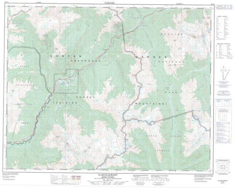
082N04 Illecillewaet Canada topo map, 1:50,000 scale
082N04 Illecillewaet NRCAN topographic map.
Includes UTM and GPS geographic coordinates (latitude and longitude). This 50k scale map is suitable for hiking, camping, and exploring, or you could frame it as a wall map.
Printed on-demand using high resolution, on heavy weight and acid free paper, or as an upgrade on a variety of synthetic materials.
Topos available on paper, Waterproof, Poly, or Tyvek. Usually shipping rolled, unless combined with other folded maps in one order.
- Product Number: NRCAN-082N04
- Parent Topo: TOPO-082N
- Map ID also known as: 082N04, 82N4, 82N04
- Unfolded Size: Approximately 26" high by 36" wide
- Weight (paper map): ca. 55 grams
- Map Type: POD NRCAN Topographic Map
- Map Scale: 1:50,000
- Geographical region: British Columbia, Canada
Neighboring Maps:
All neighboring Canadian topo maps are available for sale online at 1:50,000 scale.
Purchase the smaller scale map covering this area: Topo-082N
Spatial coverage:
Topo map sheet 082N04 Illecillewaet covers the following places:
- Broken Point - Albert Glacier - Albert Icefield - Bonney Glacier - Bonney Névé - Clarke Glacier - French Glacier - Greens Glacier - Justice Glacier - Lily Glacier - Mud Glacier - Primrose Icefield - Swanzy Glacier - Van Horne Glacier - Van Horne Névé - Schuss Lake - Albert Peak - Asulkan Ridge - Battle Range - Campion Peak - Carnes Peak - Cassiope Peak - Charity Peak - Christiana Ridge - Clachnacudainn Range - Clarke Peak - Columbia Mountains - Duncan Range - Faith Peak - Fidelity Main Peak - Fidelity Mountain - Fidelity South Peak - Findhorn Peak - Fortitude Mountain - Fulgurite Peak - Greydike Peak - Hope Peak - Jeopardy Slide - Justice Mountain - Keystone Peak - Kinbasket Mountain - Mount Abbott - Mount Afton - Mount Anstey - Mount Bonney - Mount Cotterell - Mount Coursier - Mount Green - Mount Klotz - Mount McBean - Mount Oliver - Mount Smart - Mount Swanzy - Neptune Peak - North Albert Peak - North Queest Mountain - Patience Mountain - Primrose Peak - Prudence Peak - Remillard Peak - Ross Peak - Selkirk Mountains - Sentry Mountain - Slick Mountain - The Dome - The Rampart - Tomatin Peak - Twin Butte - Virtue Mountain - Columbia-Shuswap Regional District - Regional District of Kootenay-Boundary - Glacier National Park of Canada - Mount Revelstoke National Park of Canada - Parc national du Canada des Glaciers - Parc national du Canada du Mont-Revelstoke - Steamboat Rapids - Akolkolex River - Albert Creek - Bachelor Creek - Bain Brook - Battle Brook - Benedict Creek - Bluewater Creek - Bostock Creek - Clabon Creek - Clachnacudainn Creek - Comedy Creek - Copeland Creek - Coursier Creek - East Twin Creek - Eight Mile Creek - Elm Creek - Fang Creek - Flat Creek - Freeze Creek - Game Creek - Graham Creek - Hiren Creek - Hunakwa Creek - Illecillewaet River - Incomappleux River - Jumping Creek - Kirkup Creek - Loop Brook - Maunder Creek - McDougal Creek - Mitre Creek - Myoff Creek - Nixon Creek - Ritchie Creek - Rykman Creek - Seymour River - Siegfried Creek - Slick Creek - South Albert Creek - Tangier River - Twin Creek East - Twin Creek West - Twin East Creek - Twin West Creek - Van Horne Brook - West Twin Creek - West Woolsey Creek - Woolsey (Silver) Creek - Woolsey Creek - Albert Canyon Hot Spring - Canyon Hot Springs - Albert Canyon - Albert Canyon - Canyon Hot Springs - Downie - Flat Creek - Illecillewaet - Lauretta - Ross Peak - Twin Butte - Albert Canyon - Caribou Basin - Corbin Pass - Flat Creek Pass - Groundhog Basin - Keystone Basin - Lily Pass - Little Dalles Canyon


