
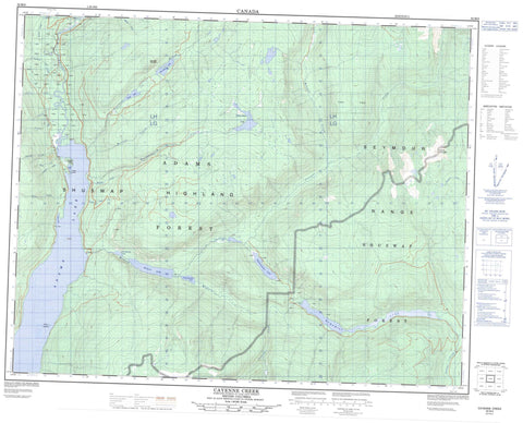
082M06 Cayenne Creek Canada topo map, 1:50,000 scale
082M06 Cayenne Creek NRCAN topographic map.
Includes UTM and GPS geographic coordinates (latitude and longitude). This 50k scale map is suitable for hiking, camping, and exploring, or you could frame it as a wall map.
Printed on-demand using high resolution, on heavy weight and acid free paper, or as an upgrade on a variety of synthetic materials.
Topos available on paper, Waterproof, Poly, or Tyvek. Usually shipping rolled, unless combined with other folded maps in one order.
- Product Number: NRCAN-082M06
- Parent Topo: TOPO-082M
- Map ID also known as: 082M06, 82M6, 82M06
- Unfolded Size: Approximately 26" high by 36" wide
- Weight (paper map): ca. 55 grams
- Map Type: POD NRCAN Topographic Map
- Map Scale: 1:50,000
- Geographical region: British Columbia, Canada
Neighboring Maps:
All neighboring Canadian topo maps are available for sale online at 1:50,000 scale.
Purchase the smaller scale map covering this area: Topo-082M
Spatial coverage:
Topo map sheet 082M06 Cayenne Creek covers the following places:
- Dolly Bay - Gordon Bay - Refuge Bay - Refuse Bay - Lammers Island - Fraser Island - Rock Islands - Adams Lake - Gannett Lake - Humamilt Lake - Little Momich Lake - Momich Lake - Stukemapten Lake - Telfer Lake - Third Momich Lake - Tsikwustum Lake - Celista Mountain - Columbia Mountains - Gannett Mountain - Monashee Mountains - Mount Celista - Seymour Range - Shuswap Highland - Columbia-Shuswap Regional District - Momich Lakes Park - Adams River - Barton Creek - Burton Creek - Cayenne Creek - Celista Creek - Clinton Creek - Dave Creek - Evans Creek - Fisher Creek - Gannett Creek - George Creek - Gollen Creek - Gordon Creek - Height Creek - Lammers Creek - Magnet Creek - McNomee Creek - Meadow Creek - Michael Creek - Momich River - Otter Creek - Schottel Creek - Stratton Creek - Tsikwustum Creek


