
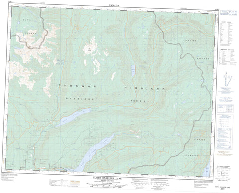
082M05 North Barriere Lake Canada topo map, 1:50,000 scale
082M05 North Barriere Lake NRCAN topographic map.
Includes UTM and GPS geographic coordinates (latitude and longitude). This 50k scale map is suitable for hiking, camping, and exploring, or you could frame it as a wall map.
Printed on-demand using high resolution, on heavy weight and acid free paper, or as an upgrade on a variety of synthetic materials.
Topos available on paper, Waterproof, Poly, or Tyvek. Usually shipping rolled, unless combined with other folded maps in one order.
- Product Number: NRCAN-082M05
- Parent Topo: TOPO-082M
- Map ID also known as: 082M05, 82M5, 82M05
- Unfolded Size: Approximately 26" high by 36" wide
- Weight (paper map): ca. 55 grams
- Map Type: POD NRCAN Topographic Map
- Map Scale: 1:50,000
- Geographical region: British Columbia, Canada
Neighboring Maps:
All neighboring Canadian topo maps are available for sale online at 1:50,000 scale.
Purchase the smaller scale map covering this area: Topo-082M
Spatial coverage:
Topo map sheet 082M05 North Barriere Lake covers the following places:
- Adams Lake - Baird Lake - East Barrière Lake - North Barrière Lake - Saskum Lake - Dunn Mountains - Dunn Peak - Dunn Range - Harp Mountain - Mount Bob Mitchell - Saskum Mountain - Dunn Peak Park - Barriere River - Barrière River - Bear Creek - Bendelin Creek - Birk Creek - Chip Creek - Dave Creek - Deadfall Creek - Dunn Creek - East Barrière River - Fennel Creek - Fennell Creek - Fisher Creek - Fison Creek - Gollen Creek - Gordon Creek - Harper Creek - John Creek - Joseph Creek - Mack Creek - Otter Creek - Russel Creek - Slate Creek - Sprague Creek - Stratton Creek - Vermelin Creek


