
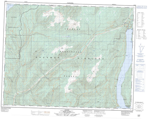
082M03 Albas Canada topo map, 1:50,000 scale
082M03 Albas NRCAN topographic map.
Includes UTM and GPS geographic coordinates (latitude and longitude). This 50k scale map is suitable for hiking, camping, and exploring, or you could frame it as a wall map.
Printed on-demand using high resolution, on heavy weight and acid free paper, or as an upgrade on a variety of synthetic materials.
Topos available on paper, Waterproof, Poly, or Tyvek. Usually shipping rolled, unless combined with other folded maps in one order.
- Product Number: NRCAN-082M03
- Parent Topo: TOPO-082M
- Map ID also known as: 082M03, 82M3, 82M03
- Unfolded Size: Approximately 26" high by 36" wide
- Weight (paper map): ca. 55 grams
- Map Type: POD NRCAN Topographic Map
- Map Scale: 1:50,000
- Geographical region: British Columbia, Canada
Neighboring Maps:
All neighboring Canadian topo maps are available for sale online at 1:50,000 scale.
Purchase the smaller scale map covering this area: Topo-082M
Spatial coverage:
Topo map sheet 082M03 Albas covers the following places:
- Seymour Arm - Nielsen Beach - Brock Point - Encounter Point - Ruckell Point - Cinnemousun Narrows - Adams Lake - Grizzly Lake - Pisima Lake - Shuswap Lake - Angle Mountain - Crowfoot Mountain - Kwikoit Mountain - Lichen Mountain - Little Lichen Mountain - Mount Evans - Mount Fowler - Mount Grice-Hutchinson - Mount Mobley - Mount Reid - Pukeashun Mountain - Shuswap Highland - Columbia-Shuswap Regional District - Cinnemousun Narrows Park - Shuswap Lake Marine Park - Adams Plateau - Interior Plateau - Blueberry Creek - Bowler Creek - Celista Creek - Cross Creek - Five Mile Creek - Gash Creek - Hudson Creek - Kwikoit Creek - Onyx Creek - Pattinson Creek - Pisima Creek - Ruby Creek - Scotch Creek - Snuffbox Creek - Sparkle Creek - Two Mile Creek - Vegetation Creek - Albas - Woods Landing


