
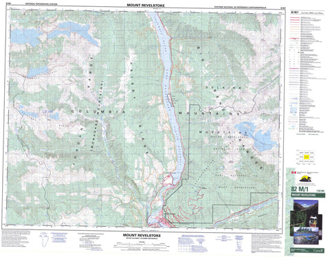
082M01 Mount Revelstoke Canada topo map, 1:50,000 scale
082M01 Mount Revelstoke NRCAN topographic map.
Includes UTM and GPS geographic coordinates (latitude and longitude). This 50k scale map is suitable for hiking, camping, and exploring, or you could frame it as a wall map.
Printed on-demand using high resolution, on heavy weight and acid free paper, or as an upgrade on a variety of synthetic materials.
Topos available on paper, Waterproof, Poly, or Tyvek. Usually shipping rolled, unless combined with other folded maps in one order.
- Product Number: NRCAN-082M01
- Parent Topo: TOPO-082M
- Map ID also known as: 082M01, 82M1, 82M01
- Unfolded Size: Approximately 26" high by 36" wide
- Weight (paper map): ca. 55 grams
- Map Type: POD NRCAN Topographic Map
- Map Scale: 1:50,000
- Geographical region: British Columbia, Canada
Neighboring Maps:
All neighboring Canadian topo maps are available for sale online at 1:50,000 scale.
Purchase the smaller scale map covering this area: Topo-082M
Spatial coverage:
Topo map sheet 082M01 Mount Revelstoke covers the following places:
- Broken Point - Revelstoke - Silvertip Falls - Clachnacudainn Icefield - French Glacier - Gordon Glacier - Inverness Glacier - Mud Glacier - Woolsey Glacier - Revelstoke Dam - Balsam Lake - Balsam Lakes - Eva Lake - Hanner Lake - Heather Lake - Lake Revelstoke - Lower Jade Lake - Millar Lake - Miller Lake - Perry Lake - Upper Jade Lake - Big Bend Ranges - Carnes Peak - Clachnacudainn Range - Columbia Mountains - Copeland Ridge - Derickson Ridge - Frisby Ridge - Inverness Peaks - Jordan Range - Keystone Peak - Kinbasket Mountain - Monashee Mountains - Mount Copeland - Mount Coursier - Mount Dickey - Mount Klotz - Mount La Forme - Mount Revelstoke - Mount St. Cyr - Mount Williamson - Neptune Peak - North Queest Mountain - Remillard Peak - Selkirk Mountains - Sentry Mountain - Columbia-Shuswap Regional District - Lake Revelstoke Park - Martha Creek Park - Mount Revelstoke National Park of Canada - Parc national du Canada du Mont-Revelstoke - Big Eddy - Steamboat Rapids - Bachelor Creek - Benedict Creek - Bews Creek - Bluewater Creek - Bridge Creek - Clachnacudainn Creek - Columbia River - Comedy Creek - Copeland Creek - Coursier Creek - Crazy Creek - Cupola Creek - Deadmans Creek - Eight Mile Creek - Elm Creek - Fleuve Columbia - Frisby Creek - Game Creek - Graham Creek - Greeley Creek - Greely Creek - Hamilton Creek - Hathaway Creek - Hiren Creek - Hunakwa Creek - Illecillewaet River - Jordan River - Kirkup Creek - La Forme Creek - Martha Creek - Maunder Creek - Myoff Creek - Nixon Creek - Sale Creek - St. Cyr Creek - West Woolsey Creek - Big Eddy - Greeley - Caribou Basin - Groundhog Basin - Ice Box - Keystone Basin - Little Dalles Canyon


