
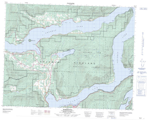
082L14 Sorrento Canada topo map, 1:50,000 scale
082L14 Sorrento NRCAN topographic map.
Includes UTM and GPS geographic coordinates (latitude and longitude). This 50k scale map is suitable for hiking, camping, and exploring, or you could frame it as a wall map.
Printed on-demand using high resolution, on heavy weight and acid free paper, or as an upgrade on a variety of synthetic materials.
Topos available on paper, Waterproof, Poly, or Tyvek. Usually shipping rolled, unless combined with other folded maps in one order.
- Product Number: NRCAN-082L14
- Parent Topo: TOPO-082L
- Map ID also known as: 082L14, 82L14
- Unfolded Size: Approximately 26" high by 36" wide
- Weight (paper map): ca. 55 grams
- Map Type: POD NRCAN Topographic Map
- Map Scale: 1:50,000
- Geographical region: British Columbia, Canada
Neighboring Maps:
All neighboring Canadian topo maps are available for sale online at 1:50,000 scale.
Purchase the smaller scale map covering this area: Topo-082L
Spatial coverage:
Topo map sheet 082L14 Sorrento covers the following places:
- Annis Bay - Bastion Bay - Blind Bay - Eagle Bay - Fraser Bay - Gillespie Bay - Heralds Bay - Hermit Bay - Horseshoe Bay - Hungry Cove - Magna Bay - Old Town Bay - Salmon Arm - Tappen Bay - Wild Rose Bay - Armstrong Point - Ashby Point - Black Point - Blake Point - Canoe Point - Engineers Point - Express Point - Gardiner Point - Haven Point - McBride Point - Paradise Point - Quartzite Point - Reedman Point - Semaphore Point - Cinnemousun Narrows - Sicamous - Margaret Falls - North Bay Indian Reserve 5 - Réserve indienne North Bay 5 - Réserve indienne Scotch Creek 4 - Réserve indienne Sicamous 3 - Scotch Creek Indian Reserve 4 - Sicamous Indian Reserve 3 - Copper Island - Steamboat Island - Little White Lake - Loftus Lake - Mara Lake - Mossy Lake - Rabie Lake - Raby Lake - Santabin Lake - Shuswap Lake - Skimikin Lake - White Lake - Aline Hill - Bastion Mountain - Bastion Mountains - Black Mountain - Mount Hilliam - Mount Riley - Mount Tappen - Notch Hill - Shuswap Highland - Columbia-Shuswap Regional District - Celista Park - Cinnemousun Narrows Park - Herald Park - Shuswap Lake Marine Park - Shuswap Lake Park - Sunnybrae Park - Sunnybrae Recreation Area - White Lake Park - Ashby Creek - Bastion Creek - Blackwood Creek - Broderick Creek - Canoe Creek - Carlin Brook - Cedar Creek - Celistown Creek - De Roy Creek - Deodar Creek - Dondaneau Creek - Eagle River - Enns Creek - Farrell Creek - Fransen Creek - Hart Creek - Heubner Creek - Hlina Creek - Hudson Creek - Hummingbird Creek - Knight Creek - Larch Hills Creek - Mara Creek - McIntyre Creek - McLellan Creek - Newsome Creek - Old Town Creek - Onyx Creek - Pari Creek - Perris Creek - Picket Creek - Rasmussen Creek - Reinecker Creek - Robinson Creek - Ross Creek - Skimikin Creek - Tappen Creek - White Creek - Wright Brook - Anglemont - Annis - Balmoral - Bastion Bay - Blind Bay - Canoe - Carlin - Celista - Eagle Bay - Fossett - Magna Bay - Mowitch - Notch Hill - Paradise Point - Scotch Creek - Six Mile Point - Sorrento - St. Ives - Sunnybrae - Tappen - Tiili Landing - Tiilis - Tiilis Landing - White Lake


