
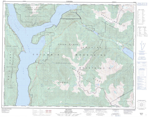
082K12 Beaton Canada topo map, 1:50,000 scale
082K12 Beaton NRCAN topographic map.
Includes UTM and GPS geographic coordinates (latitude and longitude). This 50k scale map is suitable for hiking, camping, and exploring, or you could frame it as a wall map.
Printed on-demand using high resolution, on heavy weight and acid free paper, or as an upgrade on a variety of synthetic materials.
Topos available on paper, Waterproof, Poly, or Tyvek. Usually shipping rolled, unless combined with other folded maps in one order.
- Product Number: NRCAN-082K12
- Parent Topo: TOPO-082K
- Map ID also known as: 082K12, 82K12
- Unfolded Size: Approximately 26" high by 36" wide
- Weight (paper map): ca. 55 grams
- Map Type: POD NRCAN Topographic Map
- Map Scale: 1:50,000
- Geographical region: British Columbia, Canada
Neighboring Maps:
All neighboring Canadian topo maps are available for sale online at 1:50,000 scale.
Purchase the smaller scale map covering this area: Topo-082K
Spatial coverage:
Topo map sheet 082K12 Beaton covers the following places:
- Beaton Arm - Blind Bay - Galena Bay - Northeast Arm - Northeast Arm of Upper Arrow Lake - Northwest Arm - Shelter Bay - Albert Point - Bannock Point - Blondin Point - Christie Point - Dickinson Point - Storm Point - Whiskey Point - Whisky Point - Captain Soules Falls - Gunterman Falls - Cottonwood Islands - Armstrong Lake - Staubert Lake - Trout Lake - Trout Lake - Upper Arrow Lake - Badshot Range - Blue Ridge - Columbia Mountains - Duncan Ranges - Gold Range - Great Northern Mountain - Halcyon Mountain - Lardeau Range - McPherson Hill - Monashee Mountains - Mount Murray - Mount Thompson - Selkirk Mountains - Slocan Ranges - Trout Mountain - Columbia-Shuswap Regional District - Regional District of Central Kootenay - Adams Creek - Alpha Creek - Armstrong Creek - Asher Creek - Bannock Creek - Batys Creek - Beaton Creek - Columbia River - Cranberry Creek - Dupont Creek - Fullmer Creek - Glenn Creek - Hadow Creek - Halfway Creek - Halfway River - Henrys Creek - Hill Creek - Humphries Creek - Hyham Creek - Incomappleux River - Jenning Creek - Johnson Creek - Lardeau Creek - Little Fish Creek - Mackenzie Creek - Marlow Creek - Mohawk Creek - Mountain Goat Creek - Nacillewaet Creek - Payne Creek - Pearson Creek - Pingston Creek - Pollman Creek - Reid Creek - Thompson Creek - Wallis Creek - Wilkie Creek - Halcyon Hot Springs - Halcyon Hotsprings - Arrowhead - Beaton - Ferguson - Galena - Galena Bay - Halcyon Hot Springs - Halls Landing - Shelter Bay - Sidmouth - Sidmouth - Trout Lake - Galena Pass


