
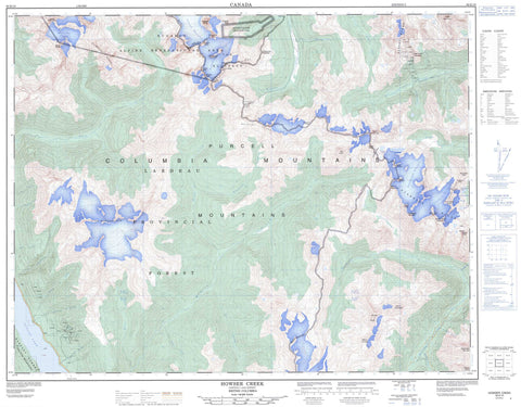
082K10 Howser Creek Canada topo map, 1:50,000 scale
082K10 Howser Creek NRCAN topographic map.
Includes UTM and GPS geographic coordinates (latitude and longitude). This 50k scale map is suitable for hiking, camping, and exploring, or you could frame it as a wall map.
Printed on-demand using high resolution, on heavy weight and acid free paper, or as an upgrade on a variety of synthetic materials.
Topos available on paper, Waterproof, Poly, or Tyvek. Usually shipping rolled, unless combined with other folded maps in one order.
- Product Number: NRCAN-082K10
- Parent Topo: TOPO-082K
- Map ID also known as: 082K10, 82K10
- Unfolded Size: Approximately 26" high by 36" wide
- Weight (paper map): ca. 55 grams
- Map Type: POD NRCAN Topographic Map
- Map Scale: 1:50,000
- Geographical region: British Columbia, Canada
Neighboring Maps:
All neighboring Canadian topo maps are available for sale online at 1:50,000 scale.
Purchase the smaller scale map covering this area: Topo-082K
Spatial coverage:
Topo map sheet 082K10 Howser Creek covers the following places:
- Kootenay Land District - Bugaboo Glacier - Carmarthen Glacier - Catamount Glacier - Centaurus Glacier - Crescent Glacier - MacCarthy Glacier - North Star Glacier - Starbird Glacier - Stockdale Glacier - Vowell Glacier - Whirlpool Glacier - Aberystwyth Lake - Duncan Lake - Juniper Lake - Thunderwater Lake - Whirlpool Lake - Anniversary Peak - Badshot Range - Black Fang - Bugaboo Spire - Carmarthen Peak - Climbing Ridge - Columbia Mountains - Duncan Ranges - Eastpost Spire - Farnham Ridge - Flattop Peak - Frenchman Mountain - Galway Peak - Glamorgan Peak - Gwendoline Mountain - Harlech Peak - Horeb Mountain - Howser Peak - Howser Spire - Lead Queen Mountain - Marmolata Mountain - Medenagan Mountain - Meden-Agan Mountain - Merioneth Peak - Mount Alpha Centauri - Mount Atlung - Mount Dorothy - Mount Galloway - Mount Griffith - Mount Harmon - Mount MacCarthy - Mount Nanette - Mount Stockdale - Mount Stone - North Star Peak - PigeonSpire - Purcell Mountains - Quintet Peaks - Rock Ridge Peak - Scotch Peaks - Septet Peaks - Septet Range - Sextet Ridge - Snowpatch Spire - Taurus Mountain - The Bugaboos - The Four Squatters - The Virgin - Thimble Peak - Tricorn Peaks - Welsh Peaks - Whitesails Mountain - Regional District of Central Kootenay - Regional District of East Kootenay - Bugaboo Glacier Park - Beartrap Creek - Behrman Creek - Big Climb Creek - Bugaboo Creek - Clancy Creek - Cockle Creek - Devils Creek - Driftwood Creek - Dunbar Creek - Dunn Creek - East Creek - Echo Creek - Edouard Creek - Farnham Creek - Forster Creek - Frances Creek - Glacier Creek - Gravelslide Creek - Horsethief Creek - Howser Creek - McGuire Creek - McLean Creek - Pat Creek - Paulding Creek - Puddingbowl Creek - Reno Creek - Rory Creek - Septet Creek - Serena Creek - Sluicebox Creek - Stockdale Creek - Suck Creek - Tea Creek - Tenise Creek - Tige Creek - Welsh Creek - Healy Landing - Howser - Bugaboo Pass - Edouard Pass - Forster Pass - Phacelia Pass - Taurus Notch


