
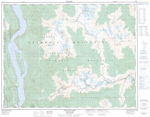
082K07 Duncan Lake Canada topo map, 1:50,000 scale
082K07 Duncan Lake NRCAN topographic map.
Includes UTM and GPS geographic coordinates (latitude and longitude). This 50k scale map is suitable for hiking, camping, and exploring, or you could frame it as a wall map.
Printed on-demand using high resolution, on heavy weight and acid free paper, or as an upgrade on a variety of synthetic materials.
Topos available on paper, Waterproof, Poly, or Tyvek. Usually shipping rolled, unless combined with other folded maps in one order.
- Product Number: NRCAN-082K07
- Parent Topo: TOPO-082K
- Map ID also known as: 082K07, 82K7, 82K07
- Unfolded Size: Approximately 26" high by 36" wide
- Weight (paper map): ca. 55 grams
- Map Type: POD NRCAN Topographic Map
- Map Scale: 1:50,000
- Geographical region: British Columbia, Canada
Neighboring Maps:
All neighboring Canadian topo maps are available for sale online at 1:50,000 scale.
Purchase the smaller scale map covering this area: Topo-082K
Spatial coverage:
Topo map sheet 082K07 Duncan Lake covers the following places:
- Lower Arm - Upper Arm - Gallop Point - Jubilee Point - Birnam Falls - Horsethief Falls - Commander Glacier - Horseshoe Glacier - Jumbo Glacier - Macbeth Icefield - Starbird Glacier - Stockdale Glacier - Duncan Dam - Duncan Lake - Graymalkin Lake - Lake of the Hanging Glacier - Archduke Mountain - Badshot Range - Bastille Mountain - B-Flat Peak - Birthday Peak - Blockhead Mountain - Camp Peak - Cauldron Mountain - Cirque Peak - Columbia Mountains - Commander Mountain - Covenant Mountain - Eagle Spire - Emperor Peak - Eyebrow Peak - Fingerboard Ridge - Glacier Dome - Goat Range - Granite Peak - Howser Ridge - Jumbo Mountain - Karnak Mountain - Mount Banquo - Mount Earl Grey - Mount Fleance - Mount Lady Macbeth - Mount Lavina - Mount Macbeth - Mount Macduff - Mount Maye - Mount Monica - Mount Simpson - Ochre Peak - Purcell Mountains - Quibble Peak - Redtop Mountain - Selkirk Mountains - Squabble Peak - The Cleaver - The Guardsmen - The Lieutenants - Toad Peak - Tranquillity Mountain - Truce Mountain - Volley Mountain - Regional District of Central Kootenay - Regional District of East Kootenay - Purcell Wilderness Conservancy - Beartrap Creek - Behrman Creek - Big Climb Creek - Birnam Creek - Crazy Creek - Duncan River - Echo Creek - Farnham Creek - Gallop Creek - Garland Creek - Glacier Creek - Griz Creek - Hamill Creek - Horsethief Creek - Howser Creek - John Creek - Jumbo Creek - Lardeau River - Leo Creek - Little Glacier Creek - McLeod Creek - Meadow Creek - Morgan Creek - Nine Mile Creek - North Creek - Pat Creek - Pharaoh Creek - Pharoah Creek - Puddingbowl Creek - Slipper Creek - South Toby Creek - Suck Creek - Tea Creek - Tige Creek - Toby Creek - Healy Landing - Howser - Marble Head - Marblehead - Earl Grey Pass - Jumbo Pass - Starbird Pass


