
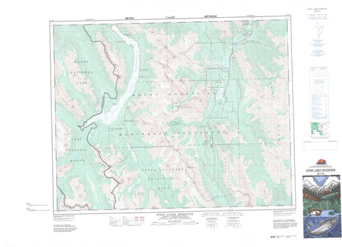
082J14 Spray Lakes Reservoir Canada topo map, 1:50,000 scale
082J14 Spray Lakes Reservoir NRCAN topographic map.
Includes UTM and GPS geographic coordinates (latitude and longitude). This 50k scale map is suitable for hiking, camping, and exploring, or you could frame it as a wall map.
Printed on-demand using high resolution, on heavy weight and acid free paper, or as an upgrade on a variety of synthetic materials.
Topos available on paper, Waterproof, Poly, or Tyvek. Usually shipping rolled, unless combined with other folded maps in one order.
- Product Number: NRCAN-082J14
- Parent Topo: TOPO-082J
- Map ID also known as: 082J14, 82J14
- Unfolded Size: Approximately 26" high by 36" wide
- Weight (paper map): ca. 55 grams
- Map Type: POD NRCAN Topographic Map
- Map Scale: 1:50,000
- Geographical region: Alberta, Canada
Neighboring Maps:
All neighboring Canadian topo maps are available for sale online at 1:50,000 scale.
Purchase the smaller scale map covering this area: Topo-082J
Spatial coverage:
Topo map sheet 082J14 Spray Lakes Reservoir covers the following places:
- O'Shaughnessy Falls - Troll Falls - Burstall Lakes - Chester Lake - Commonwealth Lake - Flat Pond - Fortress Lake - Galatea Lakes - Headwall Lakes - Hogarth Lakes - Kovach Pond - Leman Lake - Lillian Lake - Memorial Lakes - Mount Lorette Ponds - Mud Lake - Ribbon Lake - Rummel Lake - Shark Lake - Spray Lake - Spray Lakes Reservoir - Watridge Lake - Wedge Pond - Commonwealth Peak - Cone Mountain - Fisher Peak - Fisher Range - Goat Range - Kananaskis Range - Limestone Mountain - Montagnes Rocheuses - Mount Allan - Mount Birdwood - Mount Bogart - Mount Buller - Mount Burstall - Mount Chester - Mount Currie - Mount Engadine - Mount Evans-Thomas - Mount Evan-Thomas - Mount Fortune - Mount Galatea - Mount Hood - Mount Inflexible - Mount James Walker - Mount Kidd - Mount Lawson - Mount Leval - Mount Leval - Mount Lorette - Mount Lougheed - Mount McDougall - Mount Morrison - Mount Murray - Mount Nestor - Mount Packenham - Mount Shark - Mount Smuts - Mount Sparrowhawk - Mount Turbulent - Mount Turner - Mount Vavasour - Mount Warre - Mount White Man - Opal Mountains - Opal Range - Rocky Mountains - Spray Mountains - Sundance Range - The Fortress - The Wedge - White Man Mountain - White Man Mountain - Wind Mountain - Windtower - Regional District of East Kootenay - Improvement District No. 5 - Kananaskis Improvement District - Banff National Park of Canada - Kananaskis Provincial Park - Parc national du Canada Banff - Peter Lougheed Provincial Park - Spray Valley Provincial Park - Birdwood Creek - Bryant Creek - Buller Creek - Burstall Creek - Canyon Creek - Chester Creek - Commonwealth Creek - Cross River - Currie Creek - Evans-Thomas Creek - Evan-Thomas Creek - Flat Creek - French Creek - Galatea Creek - Grizzly Creek - Headwall Creek - Indian Creek - James Walker Creek - Kananaskis River - Leval Creek - Lorette Creek - Marmot Creek - North Ribbon Creek - Pigeon Creek - Porcupine Creek - Ribbon Creek - Ripple Rock Creek - Rocky Creek - Rummel Creek - Shoulder Creek - Smith-Dorrien Creek - Smuts Creek - Spray River - Spurling Creek - Turbulent Creek - Warre Creek - Warridge Creek - Wasootch Creek - Watridge Creek - West Wind Creek - White Man Creek - Wind Creek - Wind Creek - Karst Springs - Kananaskis Village - Kovach - Burstall Pass - White Man Pass


