
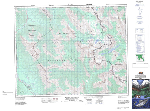
082J13 Mount Assiniboine Canada topo map, 1:50,000 scale
082J13 Mount Assiniboine NRCAN topographic map.
Includes UTM and GPS geographic coordinates (latitude and longitude). This 50k scale map is suitable for hiking, camping, and exploring, or you could frame it as a wall map.
Printed on-demand using high resolution, on heavy weight and acid free paper, or as an upgrade on a variety of synthetic materials.
Topos available on paper, Waterproof, Poly, or Tyvek. Usually shipping rolled, unless combined with other folded maps in one order.
- Product Number: NRCAN-082J13
- Parent Topo: TOPO-082J
- Map ID also known as: 082J13, 82J13
- Unfolded Size: Approximately 26" high by 36" wide
- Weight (paper map): ca. 55 grams
- Map Type: POD NRCAN Topographic Map
- Map Scale: 1:50,000
- Geographical region: Alberta, Canada
Neighboring Maps:
All neighboring Canadian topo maps are available for sale online at 1:50,000 scale.
Purchase the smaller scale map covering this area: Topo-082J
Spatial coverage:
Topo map sheet 082J13 Mount Assiniboine covers the following places:
- Brewster Glacier - Assiniboine Lake - Cerulean Lake - Coney Lake - Dog Lake - Elizabeth Lake - Game Lake - Lake Gloria - Lake Magog - Lake Terrapin - Lunette Lake - Marvel Lake - Moose Bath Pond - Nestor Lake - Og Lake - Owl Lake - Rock Lake - Sunburst Lake - Wedgwood Lake - Aurora Mountain - Aurora Mountain - Aye Mountain - Aye Mountain - Blue Range - Blue Range - Brisco Range - Cascade Rock - Cave Mountain - Cave Mountain - Chucks Ridge - Eon Mountain - Eon Mountain - Gibraltar Rock - Gloria Mountain - Golden Mountain - Hawk Ridge - Indian Peak - Kootenay Ranges - Lachine Mountain - Lunette Peak - Lunette Peak - Marvel Peak - Mitchell Range - Montagnes Rocheuses - Montagnes Rocheuses - Mount Alcantara - Mount Allenby - Mount Assiniboine - Mount Assiniboine - Mount Aurora - Mount Aye - Mount Aye - Mount Brussilof - Mount Byng - Mount Cautley - Mount Cautley - Mount Daer - Mount Docking - Mount Eon - Mount Eon - Mount Gloria - Mount Gloria - Mount Harkin - Mount Magog - Mount Magog - Mount Mercer - Mount Red Man - Mount Red Man - Mount Sam - Mount Selkirk - Mount Strom - Mount Sturdee - Mount Terrapin - Mount Terrapin - Mount Watson - Mount Wedgwood - Naiset Point - Nasswald Peak - Nasswald Peak - Nestor Peak - Nub Peak - Nublet - Octopus Mountain - Og Mountain - Og Mountain - Park Ranges - Red Man Mountain - Red Man Mountain - Rocky Mountains - Rocky Mountains - Simpson Ridge - Spar Mountain - Split Peak - Sunburst Peak - Sunburst Peaks - Sundance Range - Terrapin Mountain - Terrapin Mountain - The Marshall - The Towers - The Towers - Wedgwood Peak - Windy Ridge - Windy Ridge - Wonder Peak - Wonder Peak - Regional District of East Kootenay - Banff National Park of Canada - Kootenay National Park of Canada - Mount Assiniboine Park - Parc national du Canada Banff - Parc national du Canada Kootenay - Alcantara Creek - Allenby Creek - Assiniboine Creek - Aurora Creek - Brewster Creek - Brussilof Creek - Bryant Creek - Companion Creek - Cross River - Currie Creek - Daer Creek - Eon Creek - Extension Creek - Ferro Creek - Gog Lake - Indian Creek - Kootenay River - Lachine Creek - Lunette Creek - Magnesite Creek - Magog Creek - Marvel Creek - Meadow Creek - Mercer Creek - Mitchell River - Nestor Creek - Og Creek - Owl Creek - Pitts Creek - Sam Creek - Simpson River - Struna Creek - Surprise Creek - Turbulent Creek - Verdant Creek - Vermilion River - Wardle Creek - Wedgwood Creek - Allenby Pass - Assiniboine Pass - Assiniboine Pass - Ferro Pass - Golden Valley - Hector Gorge - Marvel Pass - Marvel Pass - Og Pass - Og Pass - Sunburst Valley - Valley of the Rocks - Wonder Pass - Wonder Pass - Lizzie Meadows - McLeod Meadows - Mitchell Meadows - Police Meadows


