
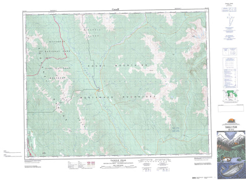
082J12 Tangle Peak Canada topo map, 1:50,000 scale
082J12 Tangle Peak NRCAN topographic map.
Includes UTM and GPS geographic coordinates (latitude and longitude). This 50k scale map is suitable for hiking, camping, and exploring, or you could frame it as a wall map.
Printed on-demand using high resolution, on heavy weight and acid free paper, or as an upgrade on a variety of synthetic materials.
Topos available on paper, Waterproof, Poly, or Tyvek. Usually shipping rolled, unless combined with other folded maps in one order.
- Product Number: NRCAN-082J12
- Parent Topo: TOPO-082J
- Map ID also known as: 082J12, 82J12
- Unfolded Size: Approximately 26" high by 36" wide
- Weight (paper map): ca. 55 grams
- Map Type: POD NRCAN Topographic Map
- Map Scale: 1:50,000
- Geographical region: British Columbia, Canada
Neighboring Maps:
All neighboring Canadian topo maps are available for sale online at 1:50,000 scale.
Purchase the smaller scale map covering this area: Topo-082J
Spatial coverage:
Topo map sheet 082J12 Tangle Peak covers the following places:
- Réserve indienne Shuswap - Shuswap Indian Reserve - Cobb Lake - Lake Olive - Brisco Range - Kootenay Ranges - Lookout Point - Mitchell Range - Montagnes Rocheuses - Mount Bryan - Mount Sinclair - Mount Soderholm - Park Ranges - Pinto Mountain - Rocky Mountains - Stanford Range - Swansea Mountain - Tangle Peak - Regional District of East Kootenay - Kootenay National Park of Canada - Parc national du Canada Kootenay - Albert River - Alcantara Creek - Bear Creek - Bornais Creek - Burnais Creek - Cochran Creek - Corne d'elan Creek - Cross River - Dry Gulch Creek - Fadeaway Creek - Kimpton Creek - Kootenay River - Little Elk Creek - Minnow Creek - Mitchell River - Nixon Creek - North Windermere Creek - Palliser River - Pitts Creek - Rubie Creek - Shaft Creek - Shuswap Creek - Silt Creek - Sinclair Creek - Stoddart Creek - Swede Creek - Tangle Creek - Witness Creek - Yearling Creek - Kimpton Pass - Miller Pass - Rocky Mountain Trench - Sinclair Pass - Salt Lake Meadows


