
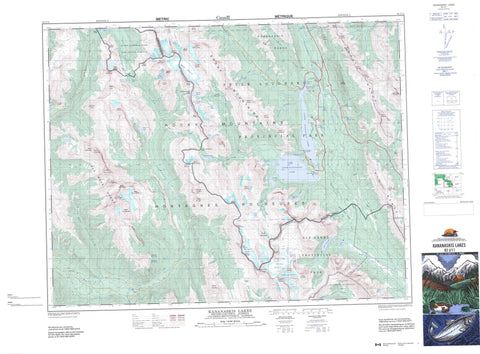
082J11 Kananaskis Lakes Canada topo map, 1:50,000 scale
082J11 Kananaskis Lakes NRCAN topographic map.
Includes UTM and GPS geographic coordinates (latitude and longitude). This 50k scale map is suitable for hiking, camping, and exploring, or you could frame it as a wall map.
Printed on-demand using high resolution, on heavy weight and acid free paper, or as an upgrade on a variety of synthetic materials.
Topos available on paper, Waterproof, Poly, or Tyvek. Usually shipping rolled, unless combined with other folded maps in one order.
- Product Number: NRCAN-082J11
- Parent Topo: TOPO-082J
- Map ID also known as: 082J11, 82J11
- Unfolded Size: Approximately 26" high by 36" wide
- Weight (paper map): ca. 55 grams
- Map Type: POD NRCAN Topographic Map
- Map Scale: 1:50,000
- Geographical region: Alberta, Canada
Neighboring Maps:
All neighboring Canadian topo maps are available for sale online at 1:50,000 scale.
Purchase the smaller scale map covering this area: Topo-082J
Spatial coverage:
Topo map sheet 082J11 Kananaskis Lakes covers the following places:
- Elpoca Falls - Fossil Falls - Opal Falls - Warspite Cascade - Castelnau Glacier - Elk Glacier - Haig Glacier - Haig Glacier - Lyautey Glacier - Mangin Glacier - Nivelle Glacier - Pétain Glacier - Hawke Island - Hogue Island - Aster Lake - Back Lake - Beatty Lake - Belgium Lake - Cadorna Lake - Elbow Lake - Fox Lake - Frozen Lake - Hidden Lake - Invincible Lake - Lawson Lake - Leman Lake - Lower Elk Lake - Lower Kananaskis Lake - Marl Lake - Maude Lake - Palliser Lake - Rawson Lake - Rockwall Lake - Sounding Lake - South Maude Lake - Sparrow's Egg Lake - Sparrows-Egg Lake - Spillway Lake - Three Isle Lake - Tipperary Lake - Upper Elk Lake - Upper Kananaskis Lake - Cradock Ridge - Defender Mountain - Elk Mountains - Elk Range - Elk Range - Elpoca Mountain - Gap Mountain - Kananaskis Range - King Creek Ridge - Lockwood Peak - Montagnes Rocheuses - Montagnes Rocheuses - Mount Aosta - Mount Back - Mount Beatty - Mount Beatty - Mount Black Prince - Mount Blane - Mount Brock - Mount Burney - Mount Castelnau - Mount Cordonnier - Mount Cordonnier - Mount Cradock - Mount Defender - Mount Foch - Mount Foch - Mount Fox - Mount Fox - Mount French - Mount Hood - Mount Indefatigable - Mount Invincible - Mount Jellicoe - Mount Jerram - Mount Joffre - Mount Joffre - Mount Kent - Mount King Albert - Mount King Albert - Mount King George - Mount Leman - Mount Leman - Mount LeRoy - Mount Lyautey - Mount Mangin - Mount Mangin - Mount Marlborough - Mount Maude - Mount Maude - Mount McCuaig - Mount McHarg - Mount McHarg - Mount Monro - Mount Murray - Mount Nivelle - Mount Nomad - Mount Northover - Mount Northover - Mount Onslow - Mount Pétain - Mount Pétain - Mount Prince Albert - Mount Prince Edward - Mount Prince George - Mount Prince Henry - Mount Prince John - Mount Princess Mary - Mount Putnik - Mount Queen Elizabeth - Mount Queen Elizabeth - Mount Queen Mary - Mount Robertson - Mount Robertson - Mount Sarrail - Mount Shatch - Mount Sir Douglas - Mount Sir Douglas - Mount Smith-Dorrien - Mount Tyrwhitt - Mount Tyrwhitt - Mount Warrior - Mount Warrior - Mount Warspite - Mount Williams - Mount Williams - Mount Wintour - Mount Worthington - Mount Worthington - Onslow Mountain - Opal Mountains - Opal Range - Park Ranges - Rocky Mountains - Rocky Mountains - Shatch Mountain - Spray Mountains - The Royal Group - The Turret - Tombstone Mountain - Warrior Mountain - Warrior Mountain - Regional District of East Kootenay - Improvement District No. 5 - Kananaskis Improvement District - Banff National Park of Canada - Elk Lakes Park - Height of the Rockies Park - Kananaskis Provincial Park - Parc national du Canada Banff - Peter Lougheed Provincial Park - Albert River - Aster Creek - Beatty Creek - Blackshale Creek - Boulton Creek - Cadorna Creek - Elbow River - Elk River - Elkan Creek - Elpoca Creek - Foch Creek - Fox Creek - French Creek - Fynn Creek - Gypsum Creek - Hood Creek - James Walker Creek - Joffre Creek - Kananaskis River - Kent Creek - King Creek - LeRoy Creek - Maude Brook - Murray Creek - Nivelle Creek - Opal Creek - Palliser River - Pétain Creek - Piper Creek - Pocaterra Creek - Queen Mary Creek - Rawson Creek - Ripple Rock Creek - Sarrail Creek - Smith-Dorrien Creek - Spotted Wolf Creek - Three Isle Creek - Tipperary Creek - Tobermory Creek - Upper Kananaskis River - Warspite Creek - White River - East Elk Pass - East Elk Pass - East Passage - Elbow Pass - Elk Pass - Elk Pass - Little Highwood Pass - North Kananaskis Pass - North Kananaskis Pass - Palliser Pass - Palliser Pass - South Kananaskis Pass - South Kananaskis Pass - Spray Pass - Spray Pass - Sylvan Pass - Turbine Canyon - West Elk Pass - West Elk Pass - West Passage - West Passage - Elkwoods Fen - Rockwall Fen


