
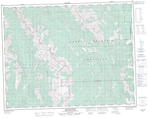
082J07 Mount Head Canada topo map, 1:50,000 scale
082J07 Mount Head NRCAN topographic map.
Includes UTM and GPS geographic coordinates (latitude and longitude). This 50k scale map is suitable for hiking, camping, and exploring, or you could frame it as a wall map.
Printed on-demand using high resolution, on heavy weight and acid free paper, or as an upgrade on a variety of synthetic materials.
Topos available on paper, Waterproof, Poly, or Tyvek. Usually shipping rolled, unless combined with other folded maps in one order.
- Product Number: NRCAN-082J07
- Parent Topo: TOPO-082J
- Map ID also known as: 082J07, 82J7, 82J07
- Unfolded Size: Approximately 26" high by 36" wide
- Weight (paper map): ca. 55 grams
- Map Type: POD NRCAN Topographic Map
- Map Scale: 1:50,000
- Geographical region: Alberta, Canada
Neighboring Maps:
All neighboring Canadian topo maps are available for sale online at 1:50,000 scale.
Purchase the smaller scale map covering this area: Topo-082J
Spatial coverage:
Topo map sheet 082J07 Mount Head covers the following places:
- Carnarvon Lake - Lake of the Horns - Loomis Lake - Abby Ridge - Baril Peak - Baril Peak - Bull Creek Hills - Courcelette Peak - Elk Mountains - Elk Range - Elk Range - Gill Peak - High Rock Range - High Rock Range - Highwood Range - Holy Cross Mountain - Montagnes Rocheuses - Montagnes Rocheuses - Mosquito Hill - Mount Abruzzi - Mount Armstrong - Mount Armstrong - Mount Bishop - Mount Bishop - Mount Bleasdell - Mount Bolton - Mount Bolton - Mount Burke - Mount Cornwell - Mount Cornwell - Mount Currie - Mount Etherington - Mount Etherington - Mount Head - Mount Jellicoe - Mount Leval - Mount Loomis - Mount Loomis - Mount Lyautey - Mount Maclaren - Mount Maclaren - Mount McLaren - Mount McPhail - Mount McPhail - Mount Muir - Mount Muir - Mount Odlum - Mount Odlum - Mount Shankland - Mount Strachan - Mount Strachan - Mount Tuxford - Mount Veits - Patterson's Peak - Plateau Mountain - Rocky Mountain Foothills - Rocky Mountains - Rocky Mountains - Weary Ridge - Municipal District of Foothills No. 31 - Regional District of East Kootenay - Improvement District No. 5 - Improvement District of Ranchland No. 6 - Kananaskis Improvement District - Mosquito Flats - Alberta - Aldridge Creek - Baril Creek - Bear Creek - Bishop Creek - Blaylock Creek - Bleasdell Creek - Britt Creek - Bull Creek - Cadorna Creek - Carnarvon Creek - Cat Creek - Cataract Creek - Cataract River - Cultus Creek - Cummings Creek - Cutthroat Creek - Deep Creek - Devitt Creek - Elk River - Etherington Creek - Fir Creek - Fitzsimmons Creek - Flat Creek - Fording River - Forsyth Creek - Gardner Creek - Greenfeed Creek - Head Creek - Henretta Creek - Highwood River - Lantern Creek - Leonard Creek - Loomis Creek - Lost Creek - Marston Creek - McPhail Creek - Miller Creek - Miller Creek - Muir Creek - Odlum Creek - Osborne Creek - Plateau Creek - Quarrie Creek - Salt Creek - Salter Creek - South Sullivan Creek - Stony Creek - Strawberry Creek - Trap Creek - Weary Creek - Wileman Creek - Wilkinson Creek - Zephyr Creek - Fording Pass - Fording River Pass - Grass Pass - Pack Trail Coulee - Weary Creek Gap - Weary Creek Gap


