
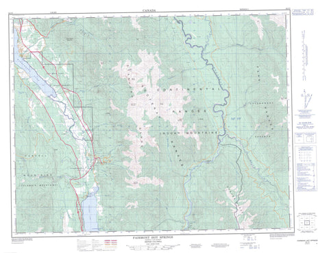
082J05 Fairmont Hot Springs Canada topo map, 1:50,000 scale
082J05 Fairmont Hot Springs NRCAN topographic map.
Includes UTM and GPS geographic coordinates (latitude and longitude). This 50k scale map is suitable for hiking, camping, and exploring, or you could frame it as a wall map.
Printed on-demand using high resolution, on heavy weight and acid free paper, or as an upgrade on a variety of synthetic materials.
Topos available on paper, Waterproof, Poly, or Tyvek. Usually shipping rolled, unless combined with other folded maps in one order.
- Product Number: NRCAN-082J05
- Parent Topo: TOPO-082J
- Map ID also known as: 082J05, 82J5, 82J05
- Unfolded Size: Approximately 26" high by 36" wide
- Weight (paper map): ca. 55 grams
- Map Type: POD NRCAN Topographic Map
- Map Scale: 1:50,000
- Geographical region: British Columbia, Canada
Neighboring Maps:
All neighboring Canadian topo maps are available for sale online at 1:50,000 scale.
Purchase the smaller scale map covering this area: Topo-082J
Spatial coverage:
Topo map sheet 082J05 Fairmont Hot Springs covers the following places:
- Armstrong Bay - Gibraltar Rock - The Hoodoos - Columbia Lake Indian Reserve 3 - Réserve indienne Columbia Lake 3 - Columbia Lake - Lyttle Lake - Lyttle Lake Reservoir - MacCarthy Lakes - MacCarthy Lakes Reservoir - Mud Lake - Tatley Slough - Windermere Lake - Columbia Mountains - Fairmont Mountain - Fairmont Ridge - Four Points Mountain - Hughes Range - Indian Head Mountain - Kootenay Ranges - Montagnes Rocheuses - Mount Aeneas - Mount Bryan - Mount Pedley - Mount Stuart - Mount Tegart - Nappe Mountain - Park Ranges - Purcell Mountains - Rocky Mountains - Regional District of East Kootenay - Columbia Lake Park - Windermere Lake Park - Brady Creek - Brewer Creek - Cedrus Creek - Cold Spring Creek - Columbia River - Dry Creek - Dutch Creek - Ellenvale Creek - Fairmont Creek - Fenwick Creek - Fleuve Columbia - Geary Creek - Hardie Creek - Holland Creek - Jack Creek - Jane Creek - Johnston Creek - Kootenay River - Lansdowne Creek - Lemon Creek - Madias Creek - Major Creek - Mary Ann Creek - Meredith Creek - North Windermere Creek - Palliser River - Pedley Creek - Prust Creek - Tatley Creek - Tukats Creek - Warspite Creek - White River - Windermere Creek - Fairmont Hot Springs - Fairmont - Fairmont Hot Springs - Rushmere - Windermere - Pedley Pass - Rocky Mountain Trench - Tegart Pass


