
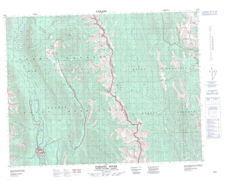
082J02 Fording River Canada topo map, 1:50,000 scale
082J02 Fording River NRCAN topographic map.
Includes UTM and GPS geographic coordinates (latitude and longitude). This 50k scale map is suitable for hiking, camping, and exploring, or you could frame it as a wall map.
Printed on-demand using high resolution, on heavy weight and acid free paper, or as an upgrade on a variety of synthetic materials.
Topos available on paper, Waterproof, Poly, or Tyvek. Usually shipping rolled, unless combined with other folded maps in one order.
- Product Number: NRCAN-082J02
- Parent Topo: TOPO-082J
- Map ID also known as: 082J02, 82J2, 82J02
- Unfolded Size: Approximately 26" high by 36" wide
- Weight (paper map): ca. 55 grams
- Map Type: POD NRCAN Topographic Map
- Map Scale: 1:50,000
- Geographical region: Alberta, Canada
Neighboring Maps:
All neighboring Canadian topo maps are available for sale online at 1:50,000 scale.
Purchase the smaller scale map covering this area: Topo-082J
Spatial coverage:
Topo map sheet 082J02 Fording River covers the following places:
- Elkford - Beehive Mountain - Beehive Mountain - Cabin Ridge - Cyclamen Ridge - Greenhills Range - Grizzly Peak - High Rock Range - High Rock Range - Montagnes Rocheuses - Montagnes Rocheuses - Mount Farquhar - Mount Farquhar - Mount Gass - Mount Gass - Mount Holcroft - Mount Holcroft - Mount Lyall - Mount Lyall - Mount O'Rourke - Mount Pierce - Mount Scrimger - Mount Scrimger - Mount Turnbull - Pasque Mountain - Plateau Mountain - Rocky Mountains - Rocky Mountains - Twin Peaks - Wapiti Mountain - Municipal District of Ranchland No. 66 - Regional District of East Kootenay - Improvement District No. 5 - Improvement District of Ranchland No. 6 - Kananaskis Improvement District - Wapiti Ski Hill - Aldridge Creek - Beehive Creek - Bingay Creek - Boivin Creek - Britt Creek - Brownie Creek - Cache Creek - Cataract Creek - Chauncey Creek - Clode Creek - Crossing Creek - Cummings Creek - Dry Creek - Elk River - Ewin Creek - Fording River - Forsyth Creek - Greenhills Creek - Henretta Creek - Honeymoon Creek - Hornickel Creek - Kilmarnock Creek - Line Creek - Lost Creek - Lowe Creek - Lyall Creek - McQuarrie Creek - Moore Creek - Oldman River - Oyster Creek - Pasque Creek - Plateau Creek - Savanna Creek - Shandley Creek - Slacker Creek - Smith Creek - Soda Creek - Speers Creek - Straight Creek - Swift Creek - Todhunter Creek - Wilkinson Creek - Clode - Fording - Greenhills - Harmer - Round Prairie - Beehive Pass - Beehive Pass - Ewin Pass


