
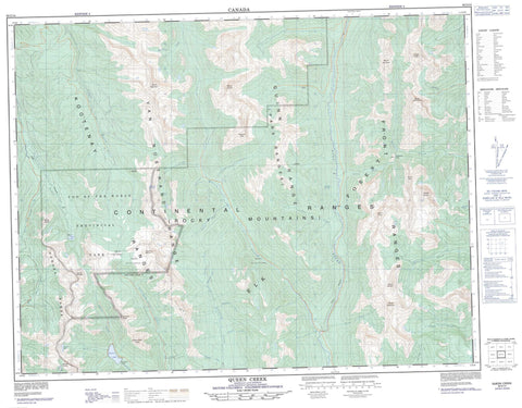
082G14 Queen Creek Canada topo map, 1:50,000 scale
082G14 Queen Creek NRCAN topographic map.
Includes UTM and GPS geographic coordinates (latitude and longitude). This 50k scale map is suitable for hiking, camping, and exploring, or you could frame it as a wall map.
Printed on-demand using high resolution, on heavy weight and acid free paper, or as an upgrade on a variety of synthetic materials.
Topos available on paper, Waterproof, Poly, or Tyvek. Usually shipping rolled, unless combined with other folded maps in one order.
- Product Number: NRCAN-082G14
- Parent Topo: TOPO-082G
- Map ID also known as: 082G14, 82G14
- Unfolded Size: Approximately 26" high by 36" wide
- Weight (paper map): ca. 55 grams
- Map Type: POD NRCAN Topographic Map
- Map Scale: 1:50,000
- Geographical region: British Columbia, Canada
Neighboring Maps:
All neighboring Canadian topo maps are available for sale online at 1:50,000 scale.
Purchase the smaller scale map covering this area: Topo-082G
Spatial coverage:
Topo map sheet 082G14 Queen Creek covers the following places:
- Fish Lake - Ruault Lake - Sparkle Lake - Summer Lake - Chrysler Peak - Empire State Peak - Hughes Range - Kootenay Ranges - Montagnes Rocheuses - Mount Dingley - Mount Doolan - Mount Frayn - Mount Gagnebin - Mount Gydosic - Mount Haynes - Mount Herchmer - Mount Morro - Mount Roth - Mount Ruault - Mount Terrion - Mount VanBuskirk - Mount Washburn - Park Ranges - Phillips Peak - Quinn Range - Rocky Mountains - Swanson Peak - Van Nostrand Range - Regional District of East Kootenay - Top of the World Park - Akoo Creek - Aldertree Creek - Alpine Creek - Basin Creek - Blackfoot Creek - Boivin Creek - Bull River - Burns Creek - Coyote Creek - Cummings Creek - East Wild Horse River - Elk River - Galbraith Creek - Goat Creek - Goathoof Creek - Kowutl Creek - Lussier River - Netherlands Creek - Nicol Creek - Norboe Creek - Nordstrum Creek - North Galbraith Creek - Nukpook Creek - Queen Creek - Quinn (Queen) Creek - Quinn Creek - Ross Creek - Ruault Creek - Sprucecone Creek - Summer Creek - Telford Creek - Weigert Creek - Wild Horse River - Hornaday Pass - Top of the World


