
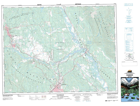
082G12 Cranbrook Canada topo map, 1:50,000 scale
082G12 Cranbrook NRCAN topographic map.
Includes UTM and GPS geographic coordinates (latitude and longitude). This 50k scale map is suitable for hiking, camping, and exploring, or you could frame it as a wall map.
Printed on-demand using high resolution, on heavy weight and acid free paper, or as an upgrade on a variety of synthetic materials.
Topos available on paper, Waterproof, Poly, or Tyvek. Usually shipping rolled, unless combined with other folded maps in one order.
- Product Number: NRCAN-082G12
- Parent Topo: TOPO-082G
- Map ID also known as: 082G12, 82G12
- Unfolded Size: Approximately 26" high by 36" wide
- Weight (paper map): ca. 55 grams
- Map Type: POD NRCAN Topographic Map
- Map Scale: 1:50,000
- Geographical region: British Columbia, Canada
Neighboring Maps:
All neighboring Canadian topo maps are available for sale online at 1:50,000 scale.
Purchase the smaller scale map covering this area: Topo-082G
Spatial coverage:
Topo map sheet 082G12 Cranbrook covers the following places:
- Cranbrook - Kimberley - Bummers Flat Indian Reserve 6 - Isidore's Ranch Indian Reserve 4 - Kootenay Indian Reserve 1 - Réserve indienne Bummers Flat 6 - Réserve indienne Isidore's Ranch 4 - Réserve indienne Kootenay 1 - Réserve indienne Saint Mary's 1A - Saint Mary's Indian Reserve 1A - Alkaline Lake - Bartholomew Lake - Bock Lake - Elmer Lake - Hahas Lake - Horseshoe Lake - Kiakho Lake - Kiakho Lakes - Kiaklo Lake - McGinty Lake - New Lake - Pattons Lake - Reade Lake - Saugum Lake - Sylvan Lake - Taylor Slough - Columbia Mountains - Kootenay Ranges - Lakit Mountain - Lone Mountain - Lone Peak - Lone Pine Hill - Montagnes Rocheuses - Moyie Range - Purcell Mountains - Rocky Mountains - Vertical Mountain - Regional District of East Kootenay - Fort Steele Heritage Town - Fort Steele Park - Bummers Flats - Angus Creek - Antwerp Creek - Arnold Creek - Booth Creek - Boulder Creek - Brewery Creek - Burnett Creek - East Wild Horse River - Elmer Creek - Fisher Creek - Herbert Creek - Highway Creek - Horseshoe Creek - Hospital Creek - Houle Creek - Jim Smith Creek - Jimsmith Creek - Joseph Creek - Khartoum Creek - Kimberley Creek - Kootenay River - Lakit Creek - Levitt Creek - Lisbon Creek - Lois Creek - Lost Dog Creek - Luke Creek - Mark Creek - Mather Creek - Mause Creek - Mayook Creek - Palmer Bar Creek - Perry Creek - Saugum Creek - Scott Creek - Slide Creek - Spirit Creek - St. Mary River - Staples Creek - Sunk Creek - Tackle Creek - Victoria Creek - Wait Creek - Wallinger Creek - Whiskey Creek - Wild Horse River - North Star Wagon Road (McGinty Trail) (1894-1902) - Steele - Chapman Camp - Concentrator - Eager - Fenwick - Fir - Fort Steele - Marysville - Marysville Station - North Star - Old Town - Porteous - Rampart - Riley - Rockyview - St. Eugene Mission - Wanklyn - Wycliffe - Isidore Canyon - Lost Dog Canyon - Lostdog Canyon - Rocky Mountain Trench - Shepherd Gulch


