
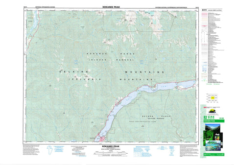
082F11 Kokanee Peak Canada topo map, 1:50,000 scale
082F11 Kokanee Peak NRCAN topographic map.
Includes UTM and GPS geographic coordinates (latitude and longitude). This 50k scale map is suitable for hiking, camping, and exploring, or you could frame it as a wall map.
Printed on-demand using high resolution, on heavy weight and acid free paper, or as an upgrade on a variety of synthetic materials.
Topos available on paper, Waterproof, Poly, or Tyvek. Usually shipping rolled, unless combined with other folded maps in one order.
- Product Number: NRCAN-082F11
- Parent Topo: TOPO-082F
- Map ID also known as: 082F11, 82F11
- Unfolded Size: Approximately 26" high by 36" wide
- Weight (paper map): ca. 55 grams
- Map Type: POD NRCAN Topographic Map
- Map Scale: 1:50,000
- Geographical region: British Columbia, Canada
Neighboring Maps:
All neighboring Canadian topo maps are available for sale online at 1:50,000 scale.
Purchase the smaller scale map covering this area: Topo-082F
Spatial coverage:
Topo map sheet 082F11 Kokanee Peak covers the following places:
- Crescent Bay - Roberts Bay - Sunshine Bay - West Arm - Bealbys Point - Cedar Point - Five Mile Point - Fivemile Point - Harrop Point - Kokanee Point - Seven Mile Point - Shannon Point - Willow Point - Fraser Narrows - Harrop Narrows - Kokanee Narrows - Nine Mile Narrows - Ninemile Narrows - Nelson - Kokanee Glacier - Crazy Jane Lake - Gibson Lake - Haiseldean Lake - Hazeldean Lake - Kokanee Lake - Kootenay Lake - Mill Lake - Noakes Lake - Noakes Lakes - Oltedi Lake - Penilynn Lake - Rosehip Lake - Ross Lake - Silvertip Lake - Six Mile Lakes - Whitelady Lake - Carlolson Mountain - Columbia Mountains - Cond Peak - Esmeralda Peak - Grays Peak - Humpback Ridge - Kokanee Peak - Kokanee Range - Mount Cornfield - Mount Eccles - Mount Ferguson - Mount Grohman - Mount Hoover - Mount John Carter - Mount Kubin - Mount Lasca - Mount Nelson - Mount Olson - Mount Peters - Mount Ruppel - Mount Yuill - Nelson Range - Olson Mountain - Outlook Mountain - Selkirk Mountains - Slocan Ranges - Sunset Mountain - Valhalla Mountains - Valhalla Range - Valhalla Ranges - James Johnstone Park - Kokanee Creek Park - Kokanee Glacier Park - Kokanee Glacier Recreation Area - West Arm Park - Crusader Flats - Alpine Creek - Alyeo Creek - Anderson Creek - Baldface Creek - Bose Creek - Bossuet Creek - Bradley Creek - Brogan Creek - Busk Creek - Cameronian Creek - Carlolson Creek - Chapleau Creek - Cheops Creek - Christian Creek - Coffee Creek - Crusader Creek - Crystal Creek - Donegal Creek - Duhamel Creek - Eight Mile Creek - Eightmile Creek - Elliott Creek - Falls Creek - Fell Creek - Five Mile Creek - Fivemile Creek - Foster Creek - Four Mile Creek - Garrity Creek - Grohman Creek - Harrop Creek - Hermitage Creek - Jackson Creek - Kokanee Creek - Laird Creek - Lasca Creek - Lemon Creek - McGuire Creek - Mineral Creek - Monument Creek - Mulvey Creek - Nilsik Creek - Olson Creek - Perry Creek - Popoff Creek - Redfish Creek - Ringrose Creek - Rixen Creek - Rucks Creek - Shannon Creek - Sitkum Creek - Slater Creek - Slocan River - Smallwood Creek - South Lemon Creek - Sproule Creek - Strickland Creek - Summit Creek - Sunset Creek - Tagart Creek - Tom Rock Creek - Trozzo Creek - Tunstall Creek - West Kokanee Creek - Winlaw Creek - Atbara - Crescent Bay - Harrop - Kokanee - Kokanee Landing - Lemon Creek - Long Beach - Longbeach - McDonalds Landing - Sunshine Bay - Troup - Willow Point - Alpine Basin - Glory Basin


