
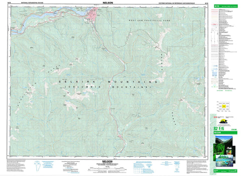
082F06 Nelson Canada topo map, 1:50,000 scale
082F06 Nelson NRCAN topographic map.
Includes UTM and GPS geographic coordinates (latitude and longitude). This 50k scale map is suitable for hiking, camping, and exploring, or you could frame it as a wall map.
Printed on-demand using high resolution, on heavy weight and acid free paper, or as an upgrade on a variety of synthetic materials.
Topos available on paper, Waterproof, Poly, or Tyvek. Usually shipping rolled, unless combined with other folded maps in one order.
- Product Number: NRCAN-082F06
- Parent Topo: TOPO-082F
- Map ID also known as: 082F06, 82F6, 82F06
- Unfolded Size: Approximately 26" high by 36" wide
- Weight (paper map): ca. 55 grams
- Map Type: POD NRCAN Topographic Map
- Map Scale: 1:50,000
- Geographical region: British Columbia, Canada
Neighboring Maps:
All neighboring Canadian topo maps are available for sale online at 1:50,000 scale.
Purchase the smaller scale map covering this area: Topo-082F
Spatial coverage:
Topo map sheet 082F06 Nelson covers the following places:
- West Arm - Burns Point - Grohman Narrows - Nelson - McDiarmid Falls - Corra Linn Dam - Narrows Island - Barrett Lake - Cottonwood Lake - Grady Lake - Kootenay Lake - Lost Lake - Marble Lake - Porcupine Lake - Qua Lake - Siwash Lake - Stuart Lake - Württemberg Lake - Baldy Mountain - Bonnington Range - Burns Meadow - Cabin Peak - Colony Peak - Columbia Mountains - Commonwealth Mountain - Copper Mountain - DeFerro Ridge - Dominion Mountain - Elise Mountain - Empire Peak - Evening Ridge - Grassy Mountain - Jubilee Mountain - Kokanee Range - Midday Peak - Morning Mountain - Mount Beattie - Mount Connor - Mount Drummond - Mount Dundee - Mount Elise - Mount Verde - Nelson Range - Red Mountain - Selkirk Mountains - Siwash Mountain - Slocan Ranges - Territory Peak - Toad Mountain - White Queen - Württemberg Mountain - Ymir Mountain - Cottonwood Lake Park - Grohman Narrows Park - West Arm Park - Whitewater - Active Creek - Anderson Creek - Apex Creek - Avalanche Creek - Barrett Creek - Bird Creek - Boulder Mill Creek - Burnt Creek - Clearwater Creek - Connor Creek - Copper Creek - Cottonwood Creek - Craigtown Creek - Cultus Creek - Dunlop Creek - Eagle Creek - Elise Creek - Erie Creek - Falls Creek - Fell Creek - Five Mile Creek - Fortynine Creek - Garrity Creek - Giveout Creek - Glade Creek - Gladstone Creek - Gold Creek - Granite Creek - Grassy Creek - Grohman Creek - Hall Creek - Hemlock Creek - Huckleberry Creek - Keno Creek - Kootenay River - Kutetl Creek - Laib Creek - Lasca Creek - Laurel Creek - Marion Brook - Midas Creek - Mohawk Creek - Noman Creek - Olive Creek - Oscar Creek - Periodical Creek - Porcupine Creek - Porter Creek - Qua Creek - Quartz Creek - Rapid Creek - Rover Creek - Rumbling Creek - Rush Creek - Salmo River - Sandy Creek - Seeman Creek - Selous Creek - Skilet Creek - Slide Creek - Smallwood Creek - Smelter Creek - Snowwater Creek - Sproule Creek - Star Creek - Stewart Creek - Trites Creek - Wally Creek - Warrington Creek - Wren Creek - Württemberg Creek - Ymir Creek - Young Creek - Young Grouse Creek - Apex - Beasley - Belford - Blewett - Bonnington - Bonnington Falls - Corra Linn - Granite - Granite Siding - Hall - Mountain - Mountain Station - Porto Rico - South Nelson - Taghum - Ymir


