
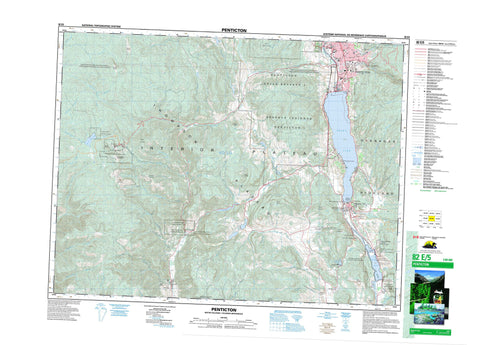
082E05 Penticton Canada topo map, 1:50,000 scale
082E05 Penticton NRCAN topographic map.
Includes UTM and GPS geographic coordinates (latitude and longitude). This 50k scale map is suitable for hiking, camping, and exploring, or you could frame it as a wall map.
Printed on-demand using high resolution, on heavy weight and acid free paper, or as an upgrade on a variety of synthetic materials.
Topos available on paper, Waterproof, Poly, or Tyvek. Usually shipping rolled, unless combined with other folded maps in one order.
- Product Number: NRCAN-082E05
- Parent Topo: TOPO-082E
- Map ID also known as: 082E05, 82E5, 82E05
- Unfolded Size: Approximately 26" high by 36" wide
- Weight (paper map): ca. 55 grams
- Map Type: POD NRCAN Topographic Map
- Map Scale: 1:50,000
- Geographical region: British Columbia, Canada
Neighboring Maps:
All neighboring Canadian topo maps are available for sale online at 1:50,000 scale.
Purchase the smaller scale map covering this area: Topo-082E
Spatial coverage:
Topo map sheet 082E05 Penticton covers the following places:
- Penticton - McIntyre Bluff - Okanagan Falls - Kamloops Division Yale Land District - Osoyoos Division Yale Land District - Similkameen Division Yale Land District - Keremeos Forks Indian Reserve 12 & 12A - Keremeos Forks Indian Reserve 12A - Penticton 2 - Penticton Indian Reserve 1 - Penticton Indian Reserve 2 - Réserve indienne Keremeos Forks 12 & 12A - Réserve indienne Keremeos Forks 12A - Réserve indienne Penticton 1 - Réserve indienne Penticton 2 - Aeneas Lake - Brent Lake - Farleigh Lake - Ford Lake - Green Lake - Horn Lake - Kitley Lake - Mahoney Lake - Marron Lake - Nickel Plate Lake - Prather Lake - Skaha Lake - Toy Lake - Trout Lake - Twin Lakes - Vaseux Lake - White Lake - Yellow Lake - Apex Mountain - Beaconsfield Mountain - Blue Mountain - Dividend Mountain - Eagle Bluff - Green Mountain - Hedges Butte - Mount Brent - Mount Hawthorne - Mount Keogan - Mount Laidlaw - Mount McLellan - Mount Parker - Mount Riordan - Okanagan Highland - Orofino Mountain - Regional District of Central Kootenay - Apex Mountain Park - Apex Mountain Recreation Area - Christie Memorial Park - Clearwater Park - Keremeos Columns Park - Nickel Plate Park - Okanagan Falls Park - Refuge d'oiseaux du lac Vaseux - Réserve nationale de faune de Vaseux-Bighorn - Vaseux Lake Bird Sanctuary - Vaseux Lake Park - Vaseux-Bighorn National Wildlife Area - Interior Plateau - Meyers Flat - Thompson Plateau - Bradshaw Creek - Broken Creek - Cahill Creek - Cedar Creek - Clark Creek - Derenzy Creek - Ellis Creek - Farleigh Creek - Felis Creek - Fragment Creek - Gillies Creek - Harkin Creek - Hedley Creek - Horn Creek - Irrigation Creek - June Creek - Kearns Creek - Keremeos Creek - Klohtelt Creek - Loak Creek - Manuel Creek - Marama Creek - Marron River - Marsel Creek - Matheson Creek - McCaig Creek - McKay Creek - McLean Creek - Nickel Plate Creek - Okanagan River - Olalla Creek - Old Tom Creek - Orofino Creek - Park Rill - Penticton Creek - Shatford Creek - Shingle Creek - Shoemaker Creek - Shuttle Creek - Shuttleworth Creek - Skaha Creek - South KeremeosCreek - Steward Creek - Strayhorse Creek - Thomas Creek - Toy Creek - Vaseux Creek - Winters Creek - Yellowlake Creek - Sheep Rock - Allen Grove - Apex Mountain - Eagle Bluff - East Penticton - Kaleden - Marron Valley - McIntyre - Meyers Flat - Okanagan Falls - Olalla - Skaha - South Penticton - West Penticton - Willowbrook - Dry Gulch - Dry Gulch Creek


