
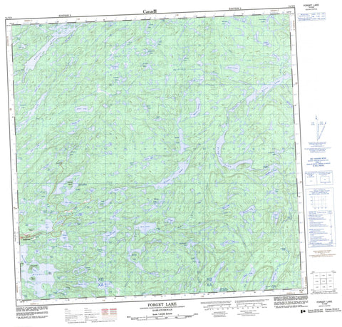
074N09 Forget Lake Canada topo map, 1:50,000 scale
074N09 Forget Lake NRCAN topographic map.
Includes UTM and GPS geographic coordinates (latitude and longitude). This 50k scale map is suitable for hiking, camping, and exploring, or you could frame it as a wall map.
Printed on-demand using high resolution, on heavy weight and acid free paper, or as an upgrade on a variety of synthetic materials.
Topos available on paper, Waterproof, Poly, or Tyvek. Usually shipping rolled, unless combined with other folded maps in one order.
- Product Number: NRCAN-074N09
- Parent Topo: TOPO-074N
- Map ID also known as: 074N09, 74N9, 74N09
- Unfolded Size: Approximately 26" high by 36" wide
- Weight (paper map): ca. 55 grams
- Map Type: POD NRCAN Topographic Map
- Map Scale: 1:50,000
- Geographical region: Saskatchewan, Canada
Neighboring Maps:
All neighboring Canadian topo maps are available for sale online at 1:50,000 scale.
Purchase the smaller scale map covering this area: Topo-074N
Spatial coverage:
Topo map sheet 074N09 Forget Lake covers the following places:
- Byers Bay - Foot Bay - Hayter Bay - Hill Bay - McKay Bay - Murmac Bay - Nelson Bay - Scott Bay - South Bay - Jones Falls - McLean Falls - Stewart Falls - Hofer Island - Lenz Island - Robinson Island - Todd Island - Umisk Island - Ace Lake - Akiskoo Lake - Akut Lake - Alces Lake - Anne Lake - Barker Lake - Bearcat Lake - Beaverlodge Lake - Beckwall Lake - Beechinor Lake - Bessette Lake - Billo Lake - Charlot Lake - Collier Lake - Cutler Lake - Daniels Lake - Dargavel Lake - Dezall Lake - Dockerill Lake - Dodds Lake - Donaldson Lake - Dubois Lake - Dusyk Lake - Dyke Lake - Eagle Lake - Edworthy Lake - Elusive Lake - Emar Lake - Essar Lake - Felix Lake - Fennell Lake - Fish Lake - Flack Lake - Fookes Lake - Forget Lake - Fredette Lake - Fretwell Lake - Friedt Lake - Fulton Lake - Gale Lake - Gatzke Lake - Geebee Lake - Gibbs Lake - Giesen Lake - Glauser Lake - Glazebrook Lake - Goehring Lake - Green Lake - Greer Lake - Griswold Lake - Hab Lake - Harbor Lake - Hayter Lake - Hoey Lake - Hunt Lake - Hutton Lake - Jones Lake - Judiesch Lake - Kvam Lake - Lac Athabasca - Lake Athabasca - Little Lake - MacLean Lake - MacPherson Lake - MacRae Lake - Max Lake - McIntyre Lake - McNutt Lake - Melma Lake - Mic Lake - Mickey Lake - Milmine Lake - Moran Lake - Mustard Lake - Neely Lake - Perry Lake - Prince Lake - Raggs Lake - Reed Lake - Richardson Lake - Right Lake - Schmoo Lake - Sells Lake - Simes Lake - St. Germain Lake - Stephens Lake - Stretching Lakes - Strike Lake - Tailing Lake - Taylor Lake - Valens Lake - Verna Lake - Viking Lake - Virgin Lake - Wahlberg Lake - Way Lake - Wilson Lake - Yahyan Lake - Zenith Lake - Zora Lake - McDonald Rapids - Ace Creek - Adams River - Black Creek - Charlot River - Felix Creek - Forget Creek - MacDonald River - McKay Creek - Neely River - Oldman River - Reed Creek - Eldorado


