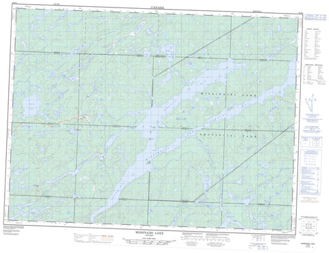
042B05 Missinaibi Lake Canada topo map, 1:50,000 scale
042B05 Missinaibi Lake NRCAN topographic map.
Includes UTM and GPS geographic coordinates (latitude and longitude). This 50k scale map is suitable for hiking, camping, and exploring, or you could frame it as a wall map.
Printed on-demand using high resolution, on heavy weight and acid free paper, or as an upgrade on a variety of synthetic materials.
Topos available on paper, Waterproof, Poly, or Tyvek. Usually shipping rolled, unless combined with other folded maps in one order.
- Product Number: NRCAN-042B05
- Parent Topo: TOPO-042B
- Map ID also known as: 042B05, 42B5, 42B05
- Unfolded Size: Approximately 26" high by 36" wide
- Weight (paper map): ca. 55 grams
- Map Type: POD NRCAN Topographic Map
- Map Scale: 1:50,000
- Geographical region: Ontario, Canada
Neighboring Maps:
All neighboring Canadian topo maps are available for sale online at 1:50,000 scale.
Purchase the smaller scale map covering this area: Topo-042B
Spatial coverage:
Topo map sheet 042B05 Missinaibi Lake covers the following places:
- Baltic Bay - Barclay Bay - Fifty Seven Bay - Iron Bay - Jenner Bay - Lee Bay - Snake Arm Bay - South Bay - Eli Point - Fairy Point - Red Granite Point - Whitefish Falls - 44 - Abbey - Abigo - Admiral - Amik - Baltic - Barclay - Brackin - Clifton - Kildare - Lang - Leeson - Marsh - Missinaibi - Rennie - Stover - Winget - Mary Island - Reva Island - Abbey Lake - Admiral Lake - Alister Lake - Anjigame Lake - Apisabigo Lake - Ash Lake - Backup Lake - Baltimore Lake - Bar Lake - Battley Lake - Bing Lake - Bobtail Lake - Bothnia Lake - Brac Lake - Burton Lake - Butler Lake - Campbell Lake - Colborne Lake - Conboy Lake - Cormick Lake - Crazy Lake - Crooked Lake - Dog Lake - Duckbill Lake - Elbow Lake - Fireline Lake - Funnel Lake - Garvey Lake - Green Tree Lake - Hall Lake - Kin Lake - Lanceley Lake - Leeson Lake - Little Missinaibi Lake - Malmo Lake - Mang Lake - Missibay Lake - Missinaibi Lake - Monk Lake - Oso Lake - Overland Lake - Oxbow Lake - Parnu Lake - Peel Lake - Pogo Lake - Prospect Lake - Puppy Lake - Quary Lake - Reek Lake - Ren Lake - Renabie Lake - Rennie Lake - Riga Lake - Ruby Lake - Sab Lake - Seal Lake - Smallboy Lake - South Greenhill Lake - Spear Lake - Spout Lake - Spring Lake - Stephenson Lake - Stover Lake - Trem Lake - Trump Lake - Tucker Lake - Renabie - Fairy Point Wilderness Area - Missinaibi Provincial Park - Whitefish Falls Wilderness Area - Abbey Creek - Admiral Creek - Apisabigo Creek - Butler Creek - Cormick Creek - Leeson Creek - Little Missinaibi River - Mang Creek - Renabie Creek - Rennie Creek - South Greenhill River - Stover Creek - Trump Creek - Height of Land Portage - Missinaibi Portage - Renabie


