
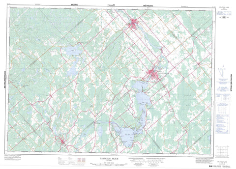
031F01 Carleton Place Canada topo map, 1:50,000 scale
031F01 Carleton Place NRCAN topographic map.
Includes UTM and GPS geographic coordinates (latitude and longitude). This 50k scale map is suitable for hiking, camping, and exploring, or you could frame it as a wall map.
Printed on-demand using high resolution, on heavy weight and acid free paper, or as an upgrade on a variety of synthetic materials.
Topos available on paper, Waterproof, Poly, or Tyvek. Usually shipping rolled, unless combined with other folded maps in one order.
- Product Number: NRCAN-031F01
- Parent Topo: TOPO-031F
- Map ID also known as: 031F01, 31F1, 31F01
- Unfolded Size: Approximately 26" high by 36" wide
- Weight (paper map): ca. 55 grams
- Map Type: POD NRCAN Topographic Map
- Map Scale: 1:50,000
- Geographical region: Ontario, Canada
Neighboring Maps:
All neighboring Canadian topo maps are available for sale online at 1:50,000 scale.
Purchase the smaller scale map covering this area: Topo-031F
Spatial coverage:
Topo map sheet 031F01 Carleton Place covers the following places:
- Black Bass Bay - Code Bay - Duff Bay - Ebbs Bay - Flintoft Bay - Greers Bay - Hunters Bay - Kinch Bay - King Bay - Kings Bay - Mallochs Bay - McEwen Bay - McGibbon Bay - Osborne Bay - Potato Bay - Pretties Bay - Thomson Bay - Allan Point - Allans Point - Anchor Point - Birch Point - Black Point - Brown Point - Dixon Point - Ebbs Point - Father Point - Grasshopper Point - King Point - Mannies Point - Manny Point - Manny's Point - McGibbon Point - McNaughton Point - Norway Point - Pickerel Point - Poole Point - Robertson Point - Robertson's Point - Rocky Point - Squaw Point - Two Oaks Point - The River - Ottawa - High Bank - The Burnt Lands - Wolf Grove - Wolves Grove - Beckwith - Dalhousie - Darling - Drummond - Goulbourn - Huntley - Lanark - Lanark - Montague - National Capital Region - Pakenham - Ramsay - Région de la Capitale nationale - Aberdeen Island - Arklan Island - Birch Island - Bowlands Island - Burnt Island - Burnt Islands - Commodore Island - Dinkey-Dooley Island - Glen Isle - Grape Island - Greig Island - Hughes Island - Ireton Island - King Island - Long Island - Long View Island - Loon Island - Menzies Island - Morris Island - Pine Island - Pretties Island - Sand Island - Stafford Island - The Two Crabs - Willis Island - Wilson Islands - Aitkman Lake - Baxter Lake - Bigford Lake - Bow Lake - Bowley Lake - Boyd Lake - Brandy Lake - Clayton Lake - Coyle Lake - Craig Lake - Cranberry Lake - Gillies Lake - Haley Lake - Harding Lake - Hardy Lake - Horn Lake - Hornes Lake - Kerr Lake - Lake on the Mount - Little Lake - Little Ramsbottoms Lake - MacKay Lake - Madden Lake - Marshall Lake - Mississippi Lake - Mort Lake - Mud Lake - North Mud Lake - Quig Lake - Ramsbottoms Lake - Reid Lake - Riven Lake - Rivens Lake - Robbs Lake - Roberts Lake - Samuel Lake - Schuyler Lake - Skunk Lake - Steward Lake - Stewart Lake - Taylor Lake - Fidlers Hill - Maloneys Hill - Murrays Hill - Carleton - Lanark - Ottawa-Carleton - Beckwith - Darling - Drummond - Drummond/North Elmsley - Fitzroy - Goulbourn - Huntley - Lanark - Lanark Highlands - Lavant, Dalhousie and North Sherbrooke - Marlborough - Montague - North Elmsley - North Gower - North West Lanark - Osgoode - Pakenham - Ramsay - Rideau - Torbolton - West Carleton - Mississippi Lake Bird Sanctuary - Mississippi Lake National Wildlife Area - Refuge d'oiseaux du Lac Mississippi - Réserve nationale de faune du Lac-Mississippi - Almonte Rapids - Andersons Rapids - Appleton Rapids - Arklan Rapids - Drummond's Rapids - Innisville Rapids - Munroes Rapids - Watsons Rapids - Widows Rapids - Bennys Creek - Black Creek - Campbells Creek - Clyde River - Code Creek - Cody Creek - Cranberry Creek - Deweys Creek - Dowdall Creek - Ebbs Creek - Gunn Creek - Gunns Creek - Haley Creek - Hopetown Creek - Indian Creek - Indian River - Jock River - Kings Creek - Laceys Creek - Lavallee Creek - Little Clyde River - McCoys Creek - McCrearys Creek - McGibbon Creek - McIntyre Creek - Middleville Creek - Mississippi River - Ruttle Creek - Sheas Creek - Sinclair Creek - Stanley Creek - Union Hall Creek - Willows Creek - Wolf Grove Creek - Carleton Place - Mississippi Mills - 10th Line Shore - Almonte - Appleton - Arklan - Ashton - Ashton Station - Beckwith - Black Corners - Blacks Corners - Boyd Settlement - Boyds - Brightside - Bullock - California - Cedardale - Clayton - Clydesville - Coleman's Shore - Cooke's Shore - Craig Shore - Ebbs Shore - Ferguson Falls - Fergusons Falls - Franktown - Franktown Station - Galbraith - Gillies Corners - Hall Mills - Halls Mills - Halpenny - Hay's Shore - Herron Mills - Herrons Mills - Hood - Hopetown - Innisville - Lake Park - Lanark - Lloyd - McCann's Shore - McCreary - McCrearys - McCrearys Beach - McCreary's Shore - McCulloughs Landing - McDiarmid's Shore - McNaughton Shore - Middleville - Montgomery Park - Petrie Shore - Pine Grove - Prestonvale - Quinn Settlement - Rathwell's Shore - Raycroft - Robertson's Shore - Rosetta - Scotch Corners - Sinclair Shore - Tatlock - Tennyson - The Tannery - Union Hall - Watsons Corners - Watson's Corners - Goodwood Marsh - Island Marsh - Snedden Meadow


