
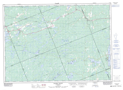
031E13 Golden Valley Canada topo map, 1:50,000 scale
031E13 Golden Valley NRCAN topographic map.
Includes UTM and GPS geographic coordinates (latitude and longitude). This 50k scale map is suitable for hiking, camping, and exploring, or you could frame it as a wall map.
Printed on-demand using high resolution, on heavy weight and acid free paper, or as an upgrade on a variety of synthetic materials.
Topos available on paper, Waterproof, Poly, or Tyvek. Usually shipping rolled, unless combined with other folded maps in one order.
- Product Number: NRCAN-031E13
- Parent Topo: TOPO-031E
- Map ID also known as: 031E13, 31E13
- Unfolded Size: Approximately 26" high by 36" wide
- Weight (paper map): ca. 55 grams
- Map Type: POD NRCAN Topographic Map
- Map Scale: 1:50,000
- Geographical region: Ontario, Canada
Neighboring Maps:
All neighboring Canadian topo maps are available for sale online at 1:50,000 scale.
Purchase the smaller scale map covering this area: Topo-031E
Spatial coverage:
Topo map sheet 031E13 Golden Valley covers the following places:
- Brunne Bay - McNeil Bay - Phillips Bay - Pigeon Bay - Smith Bay - Sunny Bay - Lee's Narrows - Long Narrows - McKee's Narrows - Dutchman Chutes - Chapman - East Mills - Ferrie - Gurd - Hardy - Lount - Machar - McConkey - McKenzie - Mills - Nipissing - Parry Sound - Patterson - Pringle - Strong - Wilson - Amulet Island - Big Chief Island - Birds Eye Island - Blueberry Island - Broderick Island - Burnt Island - Burnt Island - Centre Island - Christy Island - Cranberry Island - Crystal Island - Eby Island - Edgar Island - Edwards Island - Fowke Island - Hall Island - King Island - Long Island - Mickiebish Island - Netawanda Island - North Island - Roxy Island - Schmeler Island - Walton Island - Arthurs Lake - Bain Lake - Barney Lake - Big Deer Lake - Big Hungry Lake - Billy Lake - Bob Lake - Boss Lake - Bray Lake - Broadwell Lake - Brunner Lake - Cadden Lake - Chartier Lake - Cheer Lake - Clear Lake - Commanda Lake - Cranberry Lake - Crotch Lake - Culin Lake - De Bernard Lake - Deer Lake - Dobb Lake - Dobbs Lake - Dog Lake - Driver Lake - Duck Lake - Duck Lake - Durrell Lake - Dutchman Lake - Eagle Lake - Ell Lake - Empy Lake - Fairplay Lake - Fowke Lake - Garton Lake - Georgeen Lake - George's Lake - Halfpenny Lake - Hammond Lake - Hampel Lake - Harry May Lake - Hesman Lake - Holly Pond - Illfed Lake - Irish Lake - Jack's Lake - Jerry Lake - Julius Lake - King Lake - L Lake - Lake of Many Islands - Lawson Lake - Le Grou Lake - Little Harris Lake - Little Hungry Lake - Little Partridge Lake - Long Lake - Loon Lake - Lower Merrick Lake - Machar Lake - Maeck Lake - Mandeville Lake - May Lake - McLean Lake - McNeil Lake - Memesagamesing Lake - Merrick Lake - Milton Lake - Mountain Lake - Mud Lake - North Boundary Lake - Patterford Lake - Perch Lake - Pickerel Lake - Pine Lake - Porter Lake - Pringle Lake - Pup Lake - Raganooter Lake - Ragged Lake - Rausch Lake - Red Pine Lake - Reinhold Lake - Roaring Lake - Round Lake - Rye Lake - Schell Lake - Seagull Lake - Shorrow Lake - Sill Lake - Simms Lake - Slush Lake - Slush Lakes - Snowshoe Lake - Solwell Lakes - South Boundary Lake - Spring Lake - Stanly Lake - Stewart Lake - Stickland Lake - Sturdies Lake - Swale Lake - Sweet Lake - Theodolite Lake - Tilles Lake - Timber Lake - Tough Lake - Twisty Lake - Upper Merrick Lake - Wattenwyl Lake - Wauquimakog Lake - Weller Lake - West Deer Lake - Whitehead Lake - Whitehead Lake - Wing Lake - Wing Lake - Wolf Lake - Jack's Ridge - Tricky Hill - Chapman - Hagerman - Machar - Magnetawan - Magnetawan - Nipissing - Strong - Whitestone - Big Deer Lake Conservation Reserve - Commanda Creek Conservation Reserve - Ferrie Township Forest Conservation Reserve - Island Lake Forest and Barrens Conservation Reserve - Mikisew Provincial Park - Raganooter Lake Conservation Reserve - Big Eddy - Big Slide - Long Slide - Cedar Creek - Commanda Creek - Cramadog Creek - Distress River - Dog Creek - Farm Creek - Ferrie River - Fivemile River - Gee Creek - Harry May Creek - Kimikong River - King Creek - Little Pickerel River - Martin Creek - Murphy Creek - Peevers Creek - Pickerel River - Rainy Creek - Rivière des Rosiers - Rochette Creek - Rye Creek - Sturdies Creek - Truax Creek - Wauby Creek - Wolf River - Arnstein - Bear Valley - Bummers' Roost - Commanda - Farleys Corners - Golden Valley - Loring - Mecunoma - Port Loring - Rye - Spring Creek - Stewart Bay - Wattenwyle


