
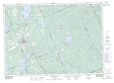
031E11 Burk s Falls Canada topo map, 1:50,000 scale
031E11 Burk s Falls NRCAN topographic map.
Includes UTM and GPS geographic coordinates (latitude and longitude). This 50k scale map is suitable for hiking, camping, and exploring, or you could frame it as a wall map.
Printed on-demand using high resolution, on heavy weight and acid free paper, or as an upgrade on a variety of synthetic materials.
Topos available on paper, Waterproof, Poly, or Tyvek. Usually shipping rolled, unless combined with other folded maps in one order.
- Product Number: NRCAN-031E11
- Parent Topo: TOPO-031E
- Map ID also known as: 031E11, 31E11
- Unfolded Size: Approximately 26" high by 36" wide
- Weight (paper map): ca. 55 grams
- Map Type: POD NRCAN Topographic Map
- Map Scale: 1:50,000
- Geographical region: Ontario, Canada
Neighboring Maps:
All neighboring Canadian topo maps are available for sale online at 1:50,000 scale.
Purchase the smaller scale map covering this area: Topo-031E
Spatial coverage:
Topo map sheet 031E11 Burk s Falls covers the following places:
- Doe Bay - Lawtons Cove - Mirror Bay - Burk's Falls - Stirling Falls - Armour - Bethune - Butt - Chapman - Finlayson - Joly - McCraney - McMurrich - Muskoka - Nipissing - Parry Sound - Perry - Proudfoot - Ryerson - Sinclair - Strong - Askin Island - Benfair Island - Birch Island - Blueberry Island - Bobby Island - Buckskin Island - Bucktooth Island - Crescent Island - Duck Island - Emerald Island - Gameja Island - Garden Island - Joy Island - Loon Island - Nottawa Island - Pine Island - Pine Island - Pollys Roost Island - Prince Edward Island - Reazin Island - Rock Island - Squirrel Island - Strawberry Island - Twin Island - Wegilbomac Island - Alderdyce Lake - Alfred Lake - Ana Lake - Askin Lake - Barre Lake - Bartlett Lake - Bay Lake - Beaver Lake - Bee Lake - Bernard Lake - Bethune Lake - Betty Lake - Bevan Lake - Bijou Lake - Blue Lake - Bluesky Lake - Bridge Lake - Brock Lake - Buck Lake - Burnt Lake - Canty Lake - Chain Lakes - Charlie's Lake - Clam Lake - Clear Lake - Coffee Lake - Cripple Lake - Crooked Lake - Cuyler Lake - Deer Lake - Dewfish Lake - Doe Lake - Duck Lake - Dump Lake - Dunstan Lake - East Ryan Lake - Elbow Lake - Emsdale Lake - Fetterley Lake - Fetterly Lake - Fifteen Lake - Finger Lake - Fourteen Lake - Fox Lake - Frank Lake - Gaitche Lake - Graphite Lake - Grass Lake - Greenish Lake - Groom Lake - Hart Lake - Hassard Lake - Hayward Lake - Himbury Lake - Hodson Lake - Hog Lake - Horn Lake - Hungry Lake - Ink Lake - Irving Lake - Island Lake - Jacks Lake - Jewel Lake - Katrine Lake - Kelsey Lake - Kernick Lake - Kippen Lake - Lac à Laurin - Larson Lake - Little Beaver Lake - Little Bethune Lake - Little Blue Lake - Little Butt Lake - Little Clam Lake - Little Doe Lake - Little Hungry Lake - Little Patterson Lake - Little Peters Lake - Little Pevensey Lake - Little Proudfoot Lake - Little Trout Lake - Little Whetstone Lake - Long Lake - Long Lake - Loon Lake - Lower Raven Lake - Mama Lake - Mason Lake - Mayer Lake - McCann Lake - McGuire Lake - Middle Shanty Lake - Mining Corporation Lake - Minnow Lake - Morgan's Lake - Music Lake - Musie Lake - North Lake - Nulty Lake - Oliphant Lake - Owl Lake - Papukiwis Lake - Pearceley Lake - Penuel Lake - Perbeth Lake - Perry Lake - Peters Lake - Pevensey Lake - Pickerel Lake - Pine Lake - Pool Lake - Proudfoot Lake - Rainy Lake - Ridge Lake - Rochester Lake - Round Lake - Sand Lake - Schamerhorn Lake - Shawshaw Lake - Simpson Lake - Snowshoe Lake - Sollman Lake - South Branch Lake - Spruce Lake - Spry Lake - Sweny Lake - Tank Lake - Tea Lake - Thirteen Lake - Thirty Lake - Three Mile Lake - Tim Lake - Travis Lake - Twentyeight Lake - Upper Raven Lake - Whetstone Lake - Widgeon Lake - Wilkins Lake - Willie Lake - Woodrow Lake - Muskoka - Armour - Chapman - Joly - Lake of Bays - Magnetawan - McMurrich - McMurrich/Monteith - Perry - Ryerson - Strong - Algonquin Provincial Park - Bear Creek Conservation Reserve - Bridge Lake Outwash Plain Forest Conservation Reserve - Chain Lakes Conservation Reserve - Upper Raft Lake Conservation Reserve - Alderdyce Creek - Bear Creek - Beggsboro Creek - Bernard Creek - Cashman Creek - Cripple Creek - Deer Lake Creek - Greenish Creek - Iagoo Creek - Jacks Creek - Larson Creek - Little East River - Little North Magnetawan River - Little Tonawanda Creek - Magnetawan River - North Magnetawan River - Proudfoot Creek - Sollman Creek - Stirling Creek - Tank Lake Creek - Tonawanda Creek - Widgeon Creek - Kearney - Ahola - Berriedale - Carss - Chetwynd - Clear Lake - Doe Lake - Emsdale - Hartfell - Katrine - Katrine Station - Kennedys - Lake Bernard - Pevensey - Pickerel Lake - Ravensworth - Sand Lake - Scotia - Stirling Falls - Strong - Wisemans Corners - Burk's Falls


