
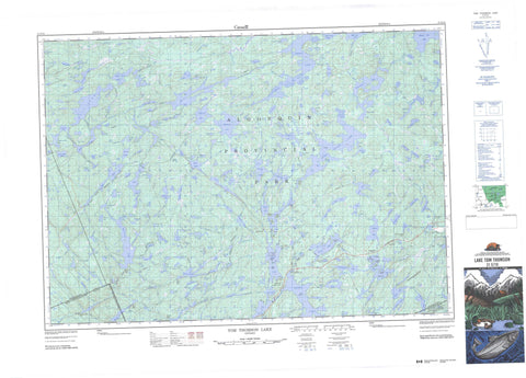
031E10 Tom Thomson Lake Canada topo map, 1:50,000 scale
031E10 Tom Thomson Lake NRCAN topographic map.
Includes UTM and GPS geographic coordinates (latitude and longitude). This 50k scale map is suitable for hiking, camping, and exploring, or you could frame it as a wall map.
Printed on-demand using high resolution, on heavy weight and acid free paper, or as an upgrade on a variety of synthetic materials.
Topos available on paper, Waterproof, Poly, or Tyvek. Usually shipping rolled, unless combined with other folded maps in one order.
- Product Number: NRCAN-031E10
- Parent Topo: TOPO-031E
- Map ID also known as: 031E10, 31E10
- Unfolded Size: Approximately 26" high by 36" wide
- Weight (paper map): ca. 55 grams
- Map Type: POD NRCAN Topographic Map
- Map Scale: 1:50,000
- Geographical region: Ontario, Canada
Neighboring Maps:
All neighboring Canadian topo maps are available for sale online at 1:50,000 scale.
Purchase the smaller scale map covering this area: Topo-031E
Spatial coverage:
Topo map sheet 031E10 Tom Thomson Lake covers the following places:
- East Arm - Grassy Bay - Red Pine Point - Western Gap - Bishop - Bower - Butt - Canisbay - Devine - Finlayson - Haliburton - Hunter - Lawrence - McCraney - McLaughlin - Muskoka - Nipissing - Peck - Big Island - Caroline Island - Cook Island - Delano Island - Gilmour Island - Joe Island - Little Wapomeo Island - Molly Island - Pathfinder Island - Pines Island - Treasure Island - Wabeno Island - Wahbahmini Island - Wapomeo Island - Acme Lake - Adrienne Lake - Ahme Lake - Alder Lake - Amyoa Lake - Aster Pond - Baby Joe Lake - Baden-Powell Lake - Bandit Lake - Banshee Lake - Barkley Lake - Bartlett Lake - Bat Lake - Beanpod Lake - Bear Lake - Beth Lake - Big Trout Lake - Bijou Lake - Birdie Lake - Bluejay Lake - Bonasa Lake - Bonita Lake - Bonito Lake - Bower Lake - Brown Lake - Brownie Lake - Bruce Lake - Brûlé Lake - Burnt Island Lake - Butt Lake - Cache Lake - Canada Jay Lake - Canisbay Lake - Canoe Lake - Casey Lake - Cashel Lake - Castor Lake - Ceres Lake - Chit Lake - Clara Lake - Clyde Lake - Coot Lake - Cranebill Lake - Crossbill Lake - Croy Lake - Curlew Lake - Dace Lake - Daisy Lake - Dan Lake - David Lake - Delano Lake - Dick Lake - Dizzy Lake - Dolly Lake - Drummer Lake - Dry Lake - Dusk Lake - East End Lake - Eel Lake - Error Lake - Eu Lake - Falcon Lake - Fauquier Lake - Favovier Lake - Fawn Lake - Faya Lake - Fern Lake - Floss Lake - Fools Lake - Forlorn Lake - Found Lake - Furrow Lake - Gill Lake - Gnat Lake - Grant Lake - Grape Lake - Groundhog Lake - Guide Lake - Hailstorm Lake - Hambone Lake - Hanes Lake - Happy Isle Lake - Happyisle Lake - Harness Lake - Hawkins Lake - He Lake - Head Lake - Hilliard Lake - Hood Lake - Hope Lake - Hot Lake - Hunter Lake - Iagoo Lake - Ink Lake - Iris Lake - Ishkuday Lake - Islet Lake - Jack Lake - Jake Lake - Jay Lake - Joe Lake - Juan Lake - Jubilee Lake - Kagh Lake - Kathlyn Lake - Kenneth Lake - Kingfisher Lake - Kite Lake - Kootchie Lake - Lady-slipper - Lark Lake - Larry Lake - Lay Lake - Lilypond Lake - Linda Lake - Little Drummer Lake - Little Eagle Lake - Little Eastend Lake - Little Island Lake - Little Joe Lake - Little McCraney Lake - Little Misty Lake - Little Otterslide Lake - Little Pugawagun Lake - Little Trout Lake - Littledoe Lake - Loft Lake - Long Thin Lake - Longspur Lake - Lulu Lake - Lupus Lake - Mack Lake - Mackinaw Lake - Maggie Lake - Magnetawan Lake - Magpie Lake - Maiden Lake - March Hare Lake - Margaret Lake - Marion Lake - McCraney Lake - McIntosh Lake - McLachlin Depot Lake - McLaughlin Depot Lake - Mermaid Lake - Mew Lake - Midget Lake - Minnow Lake - Misty Lake - Mizzy Lake - Moccasin Lake - Moray Lake - Mosquito Lake - Mossy Lake - Mubwayaka Lake - Muslim Lake - Namakootchie Lake - Nightfall Lake - Norah Lake - North Clyde Lake - North Oak Lake - Nosa Lake - Notagan Lake - Oak Lake - O'Gorman Lake - Olive Lake - Omemei Lake - Onaway Lake - Otterpaw Lake - Otterslide Lake - Ouse Lake - Owl Lake - Paddy Lake - Pandion Pond - Panther Lake - Papukiwis Lake - Pathfinder Lake - Peck Lake - Pewee Lake - Pezheki Lake - Pinay Lake - Pincher Lake - Pocket Lake - Polly Lake - Pond Lake - Ponemah Lake - Potter Lake - Provoking Lake - Pugawagun Lake - Queer Lake - Rain Lake - Rainbow Lake - Ralph Bice Lake - Raven Lake - Red Lake - Red Wing Lake - Rose Lake - Rosswood Lake - Salvelinus Lake - Sam Lake - Samos Lake - Sasajewun Lake - Sawyer Lake - Secret Lake - Shah Lake - Sheriff Pond - Shiner Lake - Sims Lake - Smoke Lake - Snowbird Lake - Snowshoe Lake - Source Lake - South Canisbay Lake - South Snowbird Lake - South Tea Lake - Southworth Lake - Splash Lake - Stammer Lake - Starling Lake - Straight Shore Lake - Stutter Lake - Sunbeam Lake - Sundance Lake - Sunny Lake - Sunset Lake - Suntan Lake - Swallow Lake - Swan Lake - Tanamakoon Lake - Tea Lake - Telma Lake - Tepee Lake - Tern Lake - Thunder Lake - Timberwolf Lake - Tom Thomson Lake - Tonakela Lake - Tony Lake - Trail Lake - Treefrog Lake - Trout Lake - Vanishing Pond - Wabasso Lake - Washa Lake - Way Lake - Wee Lake - Weed Lake - Weir Lake - Wenona Lake - West Dolly Lake - West Harry Lake - West Otterpaw Lake - West Rose Lake - White Lake - White Lake - Whitecat Lake - Whitespruce Lake - White-throat Lake - Willow Lake - Wolf Howl Pond - Wry Lake - Wye Lake - Gibraltar Rock - Haliburton - Muskoka - Algonquin Highlands - Lake of Bays - Sherborne, McClintock and Livingstone - Sherborne, McClintock, Livingstone, Lawrence and Nightingale - Sherborne, Stanhope, McClintock, Livingstone, Lawrence and Nightingale - Stanhope - Algonquin Provincial Park - Big East River Provincial Park - Ahme Creek - Amyoa Creek - Beanpod Creek - Big East River - Brown Creek - Canisbay Creek - Casey Creek - Coot Creek - Cranebill Creek - Cripple Creek - Dan Creek - David Creek - Delano Creek - Dizzy Creek - Dolly Creek - Dusk Creek - East River - Edwin Creek - Error Creek - Fern Creek - Greenish Creek - Hailstorm Creek - Hambone Creek - Head Creek - Hickory Creek - Hilliard Creek - Iagoo Creek - Iris Creek - Jack Creek - Jubilee Creek - Kenneth Creek - Kingfisher Creek - Linda Creek - Little East River - Little Oxtongue River - Little Trout Creek - Longspur Creek - Lulu Creek - Lupus Creek - Mack Creek - Mackinaw Creek - Madawaska River - Marion Creek - McCraney Creek - McIntosh Creek - Mink Creek - Mosquito Creek - Namakootchie Creek - Nightfall Creek - North Madawaska River - Nosa Creek - Oak Creek - Otterpaw Creek - Otterslide Creek - Oxtongue River - Penaish Creek - Petawawa River - Pezheki Creek - Pincher Creek - Ponemah Creek - Potter Creek - Rainbow Creek - Red Fox Creek - Shah Creek - She Creek - Sims Creek - Smoke Creek - Splash Creek - Straight Shore Creek - Stutter Creek - Swan Creek - Tasso Creek - Tea Creek - Tim River - Timberwolf Creek - Tonakela Creek - Tony Creek - Wenona Creek - Kearney - Algonquin Park - Brûlé Lake - Cache Lake - Camp Arowhon - Camp Pathfinder - Canoe Lake - Eagle Lake Landing - Joe Lake - McCraney - Taylor Statten


