
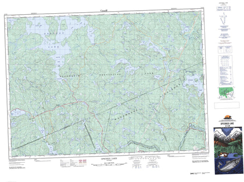
031E09 Opeongo Lake Canada topo map, 1:50,000 scale
031E09 Opeongo Lake NRCAN topographic map.
Includes UTM and GPS geographic coordinates (latitude and longitude). This 50k scale map is suitable for hiking, camping, and exploring, or you could frame it as a wall map.
Printed on-demand using high resolution, on heavy weight and acid free paper, or as an upgrade on a variety of synthetic materials.
Topos available on paper, Waterproof, Poly, or Tyvek. Usually shipping rolled, unless combined with other folded maps in one order.
- Product Number: NRCAN-031E09
- Parent Topo: TOPO-031E
- Map ID also known as: 031E09, 31E9, 31E09
- Unfolded Size: Approximately 26" high by 36" wide
- Weight (paper map): ca. 55 grams
- Map Type: POD NRCAN Topographic Map
- Map Scale: 1:50,000
- Geographical region: Ontario, Canada
Neighboring Maps:
All neighboring Canadian topo maps are available for sale online at 1:50,000 scale.
Purchase the smaller scale map covering this area: Topo-031E
Spatial coverage:
Topo map sheet 031E09 Opeongo Lake covers the following places:
- Ancona Bay - Annie Bay - Baie Alpha - East Arm - Echo Bay - Jones Bay - Mud Bay - North Arm - South Arm - Sproule Bay - High Chute - Airy - Bower - Canisbay - Clancy - Dickson - Haliburton - Lawrence - McLaughlin - Murchison - Nightingale - Nipissing - Niven - Preston - Sproule - Bates Island - Jean Island - Opeongo Island - Rose Island - Third Island - Adrienne Lake - Airy Lake - Alsever Lake - Amikeus Lake - Apukwa Lake - Arbutus Lake - Asio Lake - Bab Lake - Bailey Lake - Band Lake - Barns Lake - Bertha Lake - Big Red Lake - Billy Lake - Bit Lake - Blackfox Lake - Blueberry Lake - Bluebird Lake - Bluesea Lake - Boot Lake - Booth Lake - Brewer Lake - Bridle Lake - Bud Lake - Cameron Lake - Chewink Lake - Chick Lake - Chipmunk Lake - Clarke Lake - Cloud Lake - Cob Lake - Coon Lake - Costello Lake - Cottontail Lake - Crevice Lake - Crosstee Lake - Crotch Lake - David Thompson Lake - Dea Lake - Depot Lake - Dove Lake - Duckpond Lake - Edwin Lake - Eos Lake - Eucalia Lake - Farm Lake - Fin Lake - Fisher Lake - Fly Lake - Fog Lake - Fork Lake - Fraser Lake - Galeairy Lake - Gliskning Lake - Godda Lake - Gordon Lake - Greengrass Lake - Happy Isle Lake - Happyisle Lake - Hardtack Lake - Hartley Lake - Headstone Lake - Hermit Lake - Hidden Lake - Hiram Lake - Jackson Lake - Jean Lake - Kaw Lake - Kearney Lake - Keegos Lake - Kerry Lake - Kinglet Lake - Kitty Lake - Kortright Lake - Lake of Two Rivers - Lake St. Anthony - Langford Lake - Leaf Lake - Lil Lake - Little Lobster Lake - Little McCauley Lake - Little Minnow Lake - Little Mykiss Lake - Little Robinson Lake - Little Rock Lake - Little Vesper Lake - Lobster Lake - Lonesome Lake - Longairy Lake - Lunch Lake - Major Lake - Mallard Lake - Marmot Lake - Marshy Lake - Martin Lake - McCauley Lake - McFee Lake - McKaskill Lake - Milon Lake - Minor Lake - Mocking Lake - Mole Lake - Moonbeam Lake - Mosquito Lake - Mountain Lake - Mudville Lake - Muskrat Lake - Mykiss Lake - Myra Lake - Nick Lake - Noon Lake - North Moonbeam Lake - Norway Lake - Ojibway Lake - Onaway Lake - Oneside Lake - Opeongo Lake - Oram Lake - Otherside Lake - Owaissa Lake - Penaish Lake - Pinetree Lake - Pog Lake - Pond Lake - Presto Lake - Provoking Lake - Rail Lake - Raja Lake - Rapid Lake - Redfox Lake - Richard Lake - Ring-neck Pond - Robin Lake - Rock Lake - Rose Lake - Rosepond Lake - Round Island Lake - Rumley Lake - Ryan Lake - Ryegrass Lake - Sandmartin Lake - Sea Lake - Seed Lake - Seesaw Lake - Segwun Lake - Shall Lake - Shallnot Lake - Shanty Lake - Shirley Lake - Shrew Lake - Smith Lake - Sonia Lake - Speckledtrout Lake - Spot Lake - Sproule Lake - Starling Lake - Sugarmaple Lake - Sunday Lake - Sundown Lake - Sunray Lake - Sylvia Lake - Tadpole Lake - Tattler Lake - Thistle Lake - Tip Up Lake - Tipperairy Lake - Tip-up Lake - Tired Lake - Titmouse Lake - Tuya Lake - Ugh Lake - Upper Bluesea Lake - Vesper Lake - Victoria Lake - Von Lake - Wabeno Lake - Weasel Lake - West Headstone Lake - West Smith Lake - White Lake - Whitefish Lake - Whitegull Lake - Whitelily Lake - Whitney Lake - Wigwam Lake - Wind Lake - Wish Lake - Wright Lake - Zenobia Lake - Madawaska Highlands - Haliburton - Airy - Algonquin Highlands - Sherborne, McClintock and Livingstone - Sherborne, McClintock, Livingstone, Lawrence and Nightingale - Sherborne, Stanhope, McClintock, Livingstone, Lawrence and Nightingale - South Algonquin - Stanhope - Algonquin Provincial Park - Opeongo River Provincial Park - Upper Madawaska River Provincial Park - Long Rapids - Airy Creek - Amikeus Creek - Aylen River - Bab Creek - Bit Creek - Blackfox Creek - Bluesea Creek - Bonnechere River - Bridle Creek - Cameron Creek - Chewink Creek - Chipmunk Creek - Cob Creek - Costello Creek - Cottontail Creek - Edwin Creek - Fairy Creek - Fin Creek - Fraser Creek - Goat Creek - Graham Creek - Hailstorm Creek - Happy Isle Creek - Headstone Creek - Hermit Creek - Hidden Creek - Kaw Creek - Kearney Creek - Kerry Creek - Lobster Creek - Madawaska River - Martin Creek - McCarthy Creek - McCauley Creek - Milon Creek - Mocking Creek - Moonbeam Creek - Mosquito Creek - Mud Creek - North Madawaska River - North Moonbeam Creek - Nosa Creek - Opeongo River - Oram Creek - Penaish Creek - Pinetree Creek - Presto Creek - Red Fox Creek - Robin Creek - Rock Creek - Rumley Creek - Ryan Creek - Sandmartin Creek - Shall Creek - Shirley Creek - Sproule Creek - Sunday Creek - Sylvia Creek - Tip Up Creek - Ugh Creek - Vesper Creek - Von Creek - Wabeno Creek - Wigwam Creek - Wright Creek - Bellwood - Madawaska - Murchison - Opeongo Lodge - Rock Lake - Two Rivers - Bittern Marsh


