
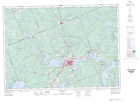
031E06 Huntsville Canada topo map, 1:50,000 scale
031E06 Huntsville NRCAN topographic map.
Includes UTM and GPS geographic coordinates (latitude and longitude). This 50k scale map is suitable for hiking, camping, and exploring, or you could frame it as a wall map.
Printed on-demand using high resolution, on heavy weight and acid free paper, or as an upgrade on a variety of synthetic materials.
Topos available on paper, Waterproof, Poly, or Tyvek. Usually shipping rolled, unless combined with other folded maps in one order.
- Product Number: NRCAN-031E06
- Parent Topo: TOPO-031E
- Map ID also known as: 031E06, 31E6, 31E06
- Unfolded Size: Approximately 26" high by 36" wide
- Weight (paper map): ca. 55 grams
- Map Type: POD NRCAN Topographic Map
- Map Scale: 1:50,000
- Geographical region: Ontario, Canada
Neighboring Maps:
All neighboring Canadian topo maps are available for sale online at 1:50,000 scale.
Purchase the smaller scale map covering this area: Topo-031E
Spatial coverage:
Topo map sheet 031E06 Huntsville covers the following places:
- Church Bay - Dwight Bay - Haystack Bay - Hunters Bay - Hutcheson's Bay - Hutchinson Bay - Long Bay - North Bay - Portage Bay - Rat Bay - Timber Bay - Wolf Bay - Dwight Beach - Breezy Point - Fox Point - Ideal Point - Menominee Point - Point Ideal - Pow Wow Point - The Narrows - McArthur Chute - Stubb's Falls - Bethune - Brunel - Cardwell - Chaffey - Franklin - McMurrich - Muskoka - Parry Sound - Perry - Sinclair - Stephenson - Stisted - Watt - Distress Dam - Alice Island - Anderson Island - Antler Island - Big Island - Bigwin Island - Centreview Island - Claire Island - Fairhope Island - Gallaugher Island - Gardner Island - Gull Island - Haystack Island - Helen Island - Hills Island - Kelley Twins Islands - Lawrence Island - Lee Islands - Marlatt Island - One Tree Island - Opal Island - Pancake Island - Peacock Island - Roberts Island - Rock Island - Rock Island - Shanibel Island - Snake Island - Togo Island - Treasure Island - Vimy Ridge Island - Wee Island - Wolf Island - Zephyr Island - Arrowhead Lake - Axe Lake - Bay Lake - Bella Lake - Benson Lake - Bing Lake - Bittern Lake - Boundary Lake - Brooks Lake - Buchanan Lake - Buck Lake - Cardwell Lake - Chub Lake - Clark Lake - Clear Lake - Compass Lake - Cooper Lake - Cotter Lake - Dotty Lake - Dreamhaven Lake - Eastell Lake - Erkett's Pond - Fairy Lake - Fawn Lake - Fish Lake - Fleming Lake - Foote Lake - Fowler Lake - Fox Lake - Golden City Lake - Groves Lake - Haller Lake - Harp Lake - Heck Lake - Hendersons Lake - Jackson's Lake - Jerry Lake - Jessop Lake - Lake of Bays - Lake Vernon - Lamberts Lake - Lancelot Lake - Langford Lake - Lassetter Lake - Lee Lake - Little Arrowhead Lake - Little Pell Lake - Long Lake - Lower Raft Lake - Mansell Lake - Mary Lake - Matthews Lake - Mayflower Lake - McBrien Pond - McReynolds Lake - Mirage Lake - North Dotty Lake - Onawaw Lake - Otter Lake - Oudaze Lake - Palette Lake - Peeler Lake - Pell Lake - Penfold Lake - Peninsula Lake - Perch Lake - Raft Lake - Rebecca Lake - Rhodes Lake - Ripple Lake - Robinson Lake - Rock Lake - Round Lake - Schamerhorn Lake - Siding Lake - Sims Lake - Skeleton Lake - Slocombe Lake - Solitaire Lake - Spider Lake - Stinking Lake - Surprise Lake - Trackler Lake - Trackler Lake - Upper Raft Lake - Verner Lake - Walker Lake - Wallington Lake - Waseosa Lake - Weeduck Lake - Whiteside Lake - Halte du Lac-Témiscamingue - Muskoka - Brunel - Chaffey - Franklin - Lake of Bays - McLean - McMurrich - McMurrich/Monteith - Muskoka Lakes - Perry - Ridout - Stephenson - Stisted - Arrowhead Provincial Park - Axe Lake Wetland Conservation Reserve - Big East River Provincial Park - Eastern Cardwell Forest Conservation Reserve - J. Albert Bauer Provincial Park - Long Lake-Lancelot Creek Conservation Reserve - Upper Raft Lake Conservation Reserve - Hood Rapids - Alderdyce Creek - Axe Creek - Bear Creek - Beaver Creek - Beggsboro Creek - Big East River - Bittern Creek - Black Creek - Boyne River - Bravender Creek - Buck River - East River - Fox Creek - Gypsy Bill Creek - Jessop Creek - Lancelot Creek - Little East River - Little Tonawanda Creek - Mirage Creek - Mirage Creek - North Branch Muskoka River - North Muskoka River - Oxtongue River - Raft Creek - Rebecca Creek - Rosseau River - Sixteen Mile Creek - The Canal - Tonawanda Creek - Wadis Creek - Wallington Creek - Britannia Shoal - Point Ideal Shoal - Seagull Rock - Huntsville - Kearney - Allensville - Antioch - Ashworth - Aspdin - Bona Vista - Bondi Village - Britannia - Britannia Road - Brooks Mill - Camp Onawaw - Canal - Centurion - Dwight - Etwell - Fern Glen - Grassmere - Haldane Hill - Hidden Valley - Hillside - Ilfracombe - Kingsway - Lancelot - Limberlost Lodge - Lumina - Martin Siding - Martins - McMurrich - Melissa - Millar Hill - North Portage - Norvern Shores - Novar - Penlake - Pitsite - Port Cunnington - Portage - Ravenscliff - Ravenscliffe - Seely - South Portage - Sprucedale - Stanleydale - Swindon - Tomelin Bluffs - Vernon Shores - Walls - Williamsport - Yearley - Yearleys


