
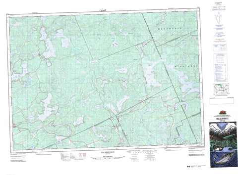
031E01 Wilberforce Canada topo map, 1:50,000 scale
031E01 Wilberforce NRCAN topographic map.
Includes UTM and GPS geographic coordinates (latitude and longitude). This 50k scale map is suitable for hiking, camping, and exploring, or you could frame it as a wall map.
Printed on-demand using high resolution, on heavy weight and acid free paper, or as an upgrade on a variety of synthetic materials.
Topos available on paper, Waterproof, Poly, or Tyvek. Usually shipping rolled, unless combined with other folded maps in one order.
- Product Number: NRCAN-031E01
- Parent Topo: TOPO-031E
- Map ID also known as: 031E01, 31E1, 31E01
- Unfolded Size: Approximately 26" high by 36" wide
- Weight (paper map): ca. 55 grams
- Map Type: POD NRCAN Topographic Map
- Map Scale: 1:50,000
- Geographical region: Ontario, Canada
Neighboring Maps:
All neighboring Canadian topo maps are available for sale online at 1:50,000 scale.
Purchase the smaller scale map covering this area: Topo-031E
Spatial coverage:
Topo map sheet 031E01 Wilberforce covers the following places:
- Dog Bay - East Bay - Hay Bay - Outlet Bay - Aylen Point - Bagley Point - Crooked Narrows - Castor Oil Chute - High Falls - Bruton - Cardiff - Dudley - Dysart - Eyre - Faraday - Glamorgan - Guilford - Haliburton - Harburn - Harcourt - Hastings - Herschel - McClure - Monmouth - Archer Island - Ball Island - Barney Island - Big Island - Cornelius Island - Dudmon Island - West Island - Allen Lake - Art Lake - Auger Lake - Baptiste Lake - Basshaunt Lake - Benoir Lake - Big Hardings Lake - Big Lighthouse Lake - Big McGarry Lake - Big Mink Lake - Big Rock Lake - Black Lake - Blue Hawk Lake - Boot Lake - Bowen Pond - Branch Lake - Bushwolf Lake - Byers Lake - Cardiff Lake - Centre Lake - Chainy Lake - Clement Lake - Cockle Lake - Colbourne Lake - Cope Lake - Cup Lake - Dead Horse Lake - Deer Lake - Diamond Lake - Dixie Lake - Drag Lake - Drurys Pond - Eagle Lake - Elephant Lake - Esson Lake - Farquhar Lake - Fishtail Lake - Fitzgerald Lake - Fork Lake - Fourcorner Lake - Grace Lake - Greenbark Lake - Gregory Lake - Guilford Lake - Haas Lake - Haliburton Lake - Halls Lake - Hamilton Lake - Harburn Lake - Hardings Lake - High Falls Pond - Hillbrow Lake - Holland Lake - Hound Lake - Huckleberry Lake - Hudson Lake - Hurst Lake - Jordan Lake - Kennaway Lake - Kennibik Lake - Kingscote Lake - Leafield Lake - Leather Root Lake - Little Allen Lake - Little Art Lake - Little Dudmon Lake - Little Esson Lake - Little Haas Lake - Little Harburn Lake - Little Lighthouse Lake - Little Maple Lake - Little McGarry Lake - Little Mink Lake - Little Mud Lake - Little Percy Lake - Little Rock Lake - Little Straggle Lake - Long Lake - Longboot Lake - Loon Lake - Lower Cardiff Lake - Lower Minnow Lake - Luke Lake - Marsden Lake - McCaslim Lake - Minnicock Lake - Minnow Lakes - Minnow Lakes - Miskwabi Lake - Moffat Pond - Monck Lake - Moore Lake - Moose Lake - Mountain Lake - North Lake - Oblong Lake - Otter Lake - Oxbend Lake - Percy Lake - Portage Lake - Pusey Lake - Rabbit Lake - Ritchey Lake - Sandox Lake - Sandy Lake - Scorch Lake - Scraggy Lake - South Boot Lake - South Little Mink Lake - South Portage Lake - Spruce Lake - Straggle Lake - Teds Lake - Twin Lakes - Two Islands Lake - Upper Crow Lake - Upper Lunan Lake - Upper Minnow Lake - Watt Lake - Weepine Lake - West Lake - Wilbermere Lake - Yankton Lake - Yates Lake - Madawaska Highlands - Haliburton - Hastings - Bangor, Wicklow and McClure - Bicroft - Cardiff - Dysart, Dudley, Harcourt, Guilford, Harburn, Bruton, Havelock, Eyre and Clyde - Faraday - Glamorgan - Hastings Highlands - Herschel - Highlands East - Monmouth - Monteagle - Algonquin Provincial Park - Gut Rapids - Allen Creek - Art Creek - Barnum Creek - Boot Creek - Burnt River - Bushwolf Creek - Cannon Creek - Cardiff Creek - Chainy Creek - Clyde Creek - Colbourne Creek - Cope Creek - Crowe River - Deer Creek - Drag River - Dudmon Creek - East Redstone River - Elephant Creek - Esson Creek - Farquhar Creek - Fourcorner Creek - Green Creek - Gregory Creek - Gull River - Haas Creek - Hamilton Creek - Harburn Creek - Hardings Creek - Hound Creek - Hudson Creek - Irondale River - Kingscote Creek - Leafield Creek - Lighthouse Creek - Little Drag River - Lunan Creek - McGarry Creek - Mink Creek - Mink Creek - Monck Creek - North York River - Perieau Creek - Redstone River - South Portage Creek - Straggle Creek - York River - Cardiff - Deer Lake - Essonville - Fort Irwin - Haliburton - Harburn - Harcourt - Highland Grove - Ironsides - Kennaway - Mumford - Pusey - South Wilberforce - Ward - Wilberforce


