
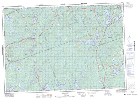
031D16 Gooderham Canada topo map, 1:50,000 scale
031D16 Gooderham NRCAN topographic map.
Includes UTM and GPS geographic coordinates (latitude and longitude). This 50k scale map is suitable for hiking, camping, and exploring, or you could frame it as a wall map.
Printed on-demand using high resolution, on heavy weight and acid free paper, or as an upgrade on a variety of synthetic materials.
Topos available on paper, Waterproof, Poly, or Tyvek. Usually shipping rolled, unless combined with other folded maps in one order.
- Product Number: NRCAN-031D16
- Parent Topo: TOPO-031D
- Map ID also known as: 031D16, 31D16
- Unfolded Size: Approximately 26" high by 36" wide
- Weight (paper map): ca. 55 grams
- Map Type: POD NRCAN Topographic Map
- Map Scale: 1:50,000
- Geographical region: Ontario, Canada
Neighboring Maps:
All neighboring Canadian topo maps are available for sale online at 1:50,000 scale.
Purchase the smaller scale map covering this area: Topo-031D
Spatial coverage:
Topo map sheet 031D16 Gooderham covers the following places:
- Clear Bay - Inlet Bay - Joe Bay - North Bay - Upper Black Bay - West Bay - Abrams Point - Ransom Point - Cope Falls - High Falls - High Falls - Anstruther - Burleigh - Cardiff - Cavendish - Chandos - Dysart - Faraday - Galway - Glamorgan - Haliburton - Hastings - Monmouth - Parry Sound - Snowdon - Angels Isle - Big Island - Big Island - Big Runway Island - Birch Island - Brown Island - Burnt Island - Calf Island - Cow Island - Crane Island - Devils Island - Doc Island - Duncombe Island - Eureka Island - Fox Islands - Geale Island - Hall Island - Hawke Island - Johnston Island - Kent Island - Loon Island - McCool Island - McKee Island - McLean Island - Mink Island - Moulds Island - Mullet Island - Nichols Island - Picnic Island - Rafter Island - Ross Island - Stringer Island - Wallace Island - Adams Lake - Alder Lake - Anderson Lake - Angler Lake - Anstruther Lake - Apsley Lake - Auger Lake - Bark Lake - Bear Lake - Beaver Lake - Bedford Lake - Billings Lake - Blue Hawk Lake - Bottle Lake - Bott's Lake - Brough Lake - Buckskin Lake - Catchacoma Lake - Centre Lake - Chandos Lake - Charles Lake - Cheddar Lake - Clanricarde Lake - Clydesdale Lake - Colbourne Lake - Contau Lake - Copper Lake - Crystal Lake - Days Lake - Devils Gap Lake - Eels Lake - Farrel Lake - Fortescue Lake - Galloway Lake - Glamor Lake - Gooderham Lake - Greens Lake - Hadlington Lake - Higgins Lake - Hook Lake - Horseshoe Lake - Koshlong Lake - Lake on the Mountain - Lasswade Lake - Leaf Lake - Little Anstruther Lake - Little Chandos Lake - Little Glamor Lake - Little Lowrie Lake - Little Tallan Lake - Long Lake - Long Pond - Loom Lake - Loon Call Lake - Lost Lake - Lower Apsley Lake - Lower Buckskin Lake - Lower Monmouth Lake - Lower Paudash Lake - Lowrie Lake - Lowry Lake - McCaslim Lake - McCue Lake - Minnicock Lake - Monck Lake - Monmouth Lake - Monrock Lake - Moxley Lake - Nogies Lake - North Eels Lake - North Pencil Lake - North Rathbun Lake - Paudash Lake - Pencil Lake - Picard Lake - Port Hope Lake - Quiet Lake - Rathbun Lake - Salerno Lake - Salmon Lake - Serpentine Lake - Silent Lake - St. Croix Lake - Stormy Lake - Sucker Lake - Tallan Lake - Tamarack Lake - Teds Lake - Tory Lake - Trooper Lake - Upper Crow Lake - Upper Monmouth Lake - White Lake - Wilbermere Lake - Greens Mountain - Haliburton - Hastings - Anson, Hindon and Minden - Bicroft - Burleigh and Anstruther - Burleigh-Anstruther-Chandos - Cardiff - Chandos - Dysart, Dudley, Harcourt, Guilford, Harburn, Bruton, Havelock, Eyre and Clyde - Faraday - Galway and Cavendish - Galway-Cavendish and Harvey - Glamorgan - Harvey - Highlands East - Lutterworth - Minden Hills - Monmouth - North Kawartha - Snowdon - Kawartha Highlands Provincial Park - Silent Lake Provincial Park - Marble Rapids - Alder Creek - Anstruther Creek - Apsley Creek - Bark Creek - Billings Creek - Bottle Creek - Brough Creek - Buckskin Creek - Burnt River - Camp Creek - Clanricarde Creek - Colbourne Creek - Cope Creek - Crowe River - Crowe River - Deer Creek - East Stony Creek - Eels Creek - Esson Creek - Farrel Creek - Gooderham Creek - Hadlington Creek - Hardings Creek - Higgins Creek - Irondale River - Laronde Creek - Lowrie Creek - McCue Creek - Mink Creek - Miskwaa Ziibi - Monmouth Creek - Monrock Creek - Moxley Creek - Nogies Creek - Pencil Creek - Port Hope Creek - Rathbun Creek - Redmond Creek - Salerno Creek - Silent Creek - Squaw River - St. Croix Creek - Stony Creek - Stormy Creek - Tallan Creek - Tory Creek - Trooper Creek - Apsley - Chandos - Chandos Lake - Cheddar - Clanricarde - Clydesdale - Ewan - Fortescue - Gooderham - Hotspur - Maxwells - Paudash - Paudash Lake - Scott Settlement - Scotts Landing - Tory Hill - Ursa


