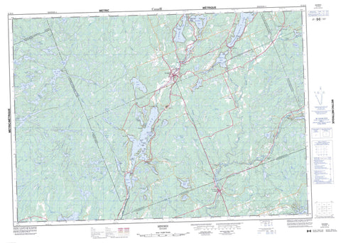
031D15 Minden Canada topo map, 1:50,000 scale
031D15 Minden NRCAN topographic map.
Includes UTM and GPS geographic coordinates (latitude and longitude). This 50k scale map is suitable for hiking, camping, and exploring, or you could frame it as a wall map.
Printed on-demand using high resolution, on heavy weight and acid free paper, or as an upgrade on a variety of synthetic materials.
Topos available on paper, Waterproof, Poly, or Tyvek. Usually shipping rolled, unless combined with other folded maps in one order.
- Product Number: NRCAN-031D15
- Parent Topo: TOPO-031D
- Map ID also known as: 031D15, 31D15
- Unfolded Size: Approximately 26" high by 36" wide
- Weight (paper map): ca. 55 grams
- Map Type: POD NRCAN Topographic Map
- Map Scale: 1:50,000
- Geographical region: Ontario, Canada
Neighboring Maps:
All neighboring Canadian topo maps are available for sale online at 1:50,000 scale.
Purchase the smaller scale map covering this area: Topo-031D
Spatial coverage:
Topo map sheet 031D15 Minden covers the following places:
- Boot Bay - Deep Bay - Iron Mine Bay - Kilcoo Harbour - Miners Bay - Sandy Bay - Chapel Point - Lookout Point - Kawartha Lakes - Moore Falls - Rackety Falls - Three Brothers Falls - Anson - Digby - Dysart - Galway - Glamorgan - Haliburton - Hindon - Laxton - Longford - Lutterworth - Minden - Muskoka - Snowdon - Somerville - Big Bob Dam - Alice Island - Battle Island - Campbell Island - Casimir Island - Cockburn Island - Easter Island - Harriet Island - Lakeview Island - Long Island - Nepawin Island - North Morris Island - Puffers Island - Shuyler Island - South Morris Island - St. Helena Island - Sugar Island - Victoria Island - Wintergreen Island - Andrews Lake - Bat Lake - Beer Lake - Big Duck Lake - Big Trout Lake - Birchbark Lake - Black Lake - Bob Lake - Boot Lake - Bow Lake - Browns Lake - Buller Lake - Canning Lake - Cedar Lake - Circlet Lake - Clear Lake - Clear Lake - Coburn Lake - Cooney Lake - Copper Lake - Corben Lake - Cranberry Lake - Crego Lake - Crooked Lake - Crotchet Lake - Crystal Lake - Davis Lake - Denna Lake - Devil's Lake - Digby Lake - Duck Lake - East Moore Lake - Elsie Lake - Fisher Lake - Fishog Lake - Goodoar Lake - Gull Lake - Head Lake - Horseshoe Lake - Howland Lake - Jordan's Lake - Kashagawigamog Lake - Kinmount Lake - Koshlong Lake - Little Bob Lake - Little Boot Lake - Little Coburn Lake - Little Elsie Lake - Little Gull Lake - Little Millward Lake - Lochlin Lake - Logan Lake - Long Lake - Lower Digby Lake - Lower Goodoar Lake - Lutterworth Lake - Marigold Lake - Millward Lake - Minden Lake - Minden Lake - Miserable Lake - Moore Lake - Moore Lake - Mountain Lake - Murphy Lake - North Beaver Lake - North Fishog Lake - North Otter Lake - North Pigeon Lake - Oak Lake - Otter Lake - Pauper Lake - Plewman Lake - Pockett Lake - Rainy Lake - Red Boat Lake - Round Lake - Salerno Lake - Sam's Lake - Scrabble Lake - Sheldon Lake - Sickle Lake - Sludge Lake - Smudge Lake - Snake Lakes - South Anson Lake - South Beaver Lake - South Lake - Spar Lake - Thrasher Lake - Trawler Lake - Trounce Lake - Union Lake - Upper Andrews Lake - Victoria Lake - West Lake - West Moore Lake - West Moore's Lake - West Victoria Lake - Wolf Lake - Haliburton - Muskoka - Victoria - Anson, Hindon and Minden - Bexley - Bicroft - Bobcaygeon/Verulam - Carden - Carden/Dalton - Cardiff - Dalton - Dysart, Dudley, Harcourt, Guilford, Harburn, Bruton, Havelock, Eyre and Clyde - Eldon - Emily - Fenelon - Galway and Cavendish - Galway-Cavendish and Harvey - Glamorgan - Harvey - Highlands East - Laxton, Digby and Longford - Lutterworth - Manvers - Mariposa - Minden Hills - Monmouth - Ops - Snowdon - Somerville - Verulam - Dalton Digby Wildlands Provincial Park - Queen Elizabeth II Wildlands Provincial Park - Andrews Creek - Anson Creek - Bark Creek - Beer Creek - Black Creek - Blackberry Creek - Bob Creek - Burnt River - Cache Creek - Coburn Creek - Corben Creek - Crego Creek - Denna Creek - Digby Creek - Drag River - Gold Creek - Gull River - Head River - Howland Creek - Irondale River - Kendrick Creek - Koshlong Creek - Lochlin Creek - Lutterworth Creek - Miners Creek - Plewman Creek - Salerno Creek - Sheldon Creek - Sickle Creek - Smudge Creek - Thrasher Creek - Trawler Creek - Union Creek - Bracebridge - Allsaw - Buller - Cardiff - Deep Bay - Donald - Dutch Line - Elsie - Furnace Falls - Gelert - Horseshoe Lake - Howland - Ingoldsby - Irondale - Kilcoo Camp - Kinmount - Lochlin - Lutterworth - Minden - Miners Bay - Moore Falls - Mount Irwin - Rackety


