
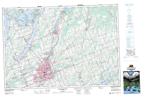
031D08 Peterborough Canada topo map, 1:50,000 scale
031D08 Peterborough NRCAN topographic map.
Includes UTM and GPS geographic coordinates (latitude and longitude). This 50k scale map is suitable for hiking, camping, and exploring, or you could frame it as a wall map.
Printed on-demand using high resolution, on heavy weight and acid free paper, or as an upgrade on a variety of synthetic materials.
Topos available on paper, Waterproof, Poly, or Tyvek. Usually shipping rolled, unless combined with other folded maps in one order.
- Product Number: NRCAN-031D08
- Parent Topo: TOPO-031D
- Map ID also known as: 031D08, 31D8, 31D08
- Unfolded Size: Approximately 26" high by 36" wide
- Weight (paper map): ca. 55 grams
- Map Type: POD NRCAN Topographic Map
- Map Scale: 1:50,000
- Geographical region: Ontario, Canada
Neighboring Maps:
All neighboring Canadian topo maps are available for sale online at 1:50,000 scale.
Purchase the smaller scale map covering this area: Topo-031D
Spatial coverage:
Topo map sheet 031D08 Peterborough covers the following places:
- Donaghue Bay - Fiddlers Bay - Fife Bay - Fife's Bay - Gannon Bay - Gifford Bay - Harrington Bay - Lancaster Bay - Morrow Bay - O'Rielly Bay - Sandy Creek Bay - Sandy Point Bay - Scollard Bay - Telford Bay - Tindle Bay - Webb Bay - Youngs Cove - Young's Cove - Battery Point - Birdsalls Point - Cadigan Point - Cameron Point - Coppaway Point - Davis Point - Gannon Point - Haig Point - Hickson Point - Lute Point - McGuire Point - Morrow Point - O'Rielly Point - Rollies Point - Sandy Point - Scollard Point - Spencer Point - Telephone Point - Blind Channel - Chemong Narrows - Chemung Narrows - Gannon Narrows - Harrington Narrows - Mill Race - Kawartha Lakes - Peterborough - Alnwick - Asphodel - Cavan - Douro - Dummer - Emily - Ennismore - Harvey - Monaghan - North Monaghan - Northumberland - Otonabee - Percy - Peterborough - Smith - South Monaghan - Verulam - Curve Lake 35A - Curve Lake First Nation 35 - Curve Lake First Nation Indian Reserve 35 - Curve Lake Indian Reserve 35 - Curve Lake Indian Reserve 35A - Islands in the Trent Waters 36A - Islands in the Trent Waters Indian Reserve 36A - Réserve indienne Curve Lake 35 - Réserve indienne Curve Lake 35A - Réserve indienne Curve Lake First Nation 35 - Réserve indienne Islands in the Trent Waters 36A - Big Island - Birch Island - Blewett Island - Boyd Island - Brushy Island - Burnt Island - Chief Island - Douglas Island - Emerald Isle - Farley Island - Flat Island - Flat Islands - Fothergill Island - Fox Island - Goose Island - Gordonstoun Island - Grape Island - Grenadier Island - Heron Island - Hills Island - Horseshoe Island - Jacob Island - Joe Island - Johnston Island - Kelly Island - Kishgo Island - Margaret Island - McKenty Island - Mink Island - Morrsey Island - Nichol Island - Paradise Island - Polly Cow Island - Polly Island - Prince Andrew Island - Red Rock Island - Reserve Island - Robinsons Island - Rottenstone Island - Scriver Island - Seaweed Island - Seaweed Islands - Second Island - Snake Island - Sugar Bush Island - Third Island - Thorne Island - Webster Island - White Island - Best's Pond - Buckhorn Lake - Buckley Lake - Chemong Lake - Chemung Lake - Clear Lake - Katchewanooka Lake - Katchiwano Lake - Kawartha Lakes - Lily Lake - Little Lake - Little Mud Lake - Long Lake - Maloney's Lake - Moore Lake - Pigeon Lake - Quarry Lake - Rice Lake - Rotten Lake - Upper Chemong Lake - Upper Chemung Lake - Armour Hill - English Hill - Fife Hill - Frank Hill - Green Hill - Northumberland - Peterborough - Victoria - Alnwick - Alnwick/Haldimand - Asphodel - Asphodel-Norwood - Bexley - Bobcaygeon/Verulam - Carden - Carden/Dalton - Cavan - Cavan-Millbrook-North Monaghan - Dalton - Douro - Douro-Dummer - Douro-Dummer - Dummer - Eldon - Emily - Ennismore - Fenelon - Galway and Cavendish - Galway-Cavendish and Harvey - Haldimand - Harvey - Laxton, Digby and Longford - Manvers - Mariposa - North Monaghan - Ops - Otonabee - Otonabee-South Monaghan - Percy - Seymour - Smith - Smith-Ennismore - Smith-Ennismore-Lakefield - Somerville - South Monaghan - Verulam - Chemong Lake Conservation Area - Lieu historique national du Canada de la Voie-Navigable-Trent--Severn - Lieu historique national du Canada de l'Écluse-Ascenseur-de-Peterborough - Mark S. Burnham Provincial Park - Peterborough Lift Lock National Historic Site of Canada - Trent--Severn Waterway National Historic Site of Canada - Warsaw Caves Conservation Area - Bear Creek - Bears Creek - Birdsalls Creek - Indian River - Jackson Creek - May's Creek - Mead Creek - Meade Creek - Miller Creek - Otonabee River - Ouse River - Potash Creek - Sawer Creek - Snelgrove Brook - Trent River - West Ouse River - Whitlaw Creek - Tilley's Hole - Curve Shoal - East Rice Bed - Lynch's Rock - Rush Shoals - Campbellford/Seymour - Campbellford/Seymour, Percy, Hastings - Trent Hills - Ashburnham - Asphodel Station - Assumption - Auburn Mills - Bests Station - Bethel - Birdsalls - Blezard - Botulf Siding - Braund Port - Bridgenorth - Byersville - Cameron - Centre Dummer - Chemong Heights - Chemong Park - Chemung Park - Claraday - Coldsprings - Collison Heights - Connaught Shore - Cooper's Trailer Park - Cottesloe - Crawford's Grove - Curve Lake - Donwood - Douro - Downers Corners - Drummond - East Emily - Edgewood Park - Edmison Heights - Ennismore - Fairbairn Meadows - Fife's Bay - Five Corners - Flood's Landing - Fowlers Corners - Galesburg - Gannon Beach - Gannon Village - Greenhill - Guerin - Hill Settlement - Indian River - Jackson Heights - Jermyn - Kawartha Heights - Kawartha Hideaway - Keene Station - Kimberley Park - Lakefield - Lang - Mount Pleasant - Murray Hill - Nassau - Oak Orchard - Orange Corners - Otonabee Siding - Selwyn - South Beach - South Dummer - Stewart Heights - Terra View Heights - Village Meadows - Villiers - Warsaw - Westmount - Westwood - Windward Sands - Woodland Acres - Woodview - Yankee Bonnet - Young's Cove - Youngs Point - Youngstown - Cavan Bog - Fultons Bog


