
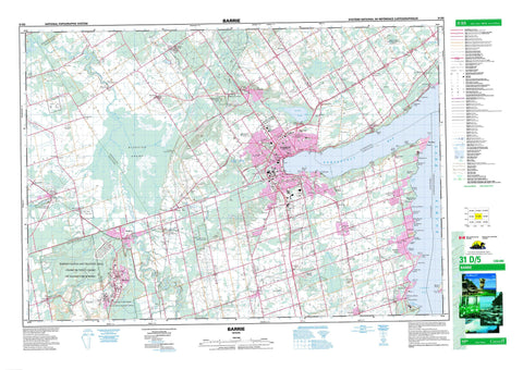
031D05 Barrie Canada topo map, 1:50,000 scale
031D05 Barrie NRCAN topographic map.
Includes UTM and GPS geographic coordinates (latitude and longitude). This 50k scale map is suitable for hiking, camping, and exploring, or you could frame it as a wall map.
Printed on-demand using high resolution, on heavy weight and acid free paper, or as an upgrade on a variety of synthetic materials.
Topos available on paper, Waterproof, Poly, or Tyvek. Usually shipping rolled, unless combined with other folded maps in one order.
- Product Number: NRCAN-031D05
- Parent Topo: TOPO-031D
- Map ID also known as: 031D05, 31D5, 31D05
- Unfolded Size: Approximately 26" high by 36" wide
- Weight (paper map): ca. 55 grams
- Map Type: POD NRCAN Topographic Map
- Map Scale: 1:50,000
- Geographical region: Ontario, Canada
Neighboring Maps:
All neighboring Canadian topo maps are available for sale online at 1:50,000 scale.
Purchase the smaller scale map covering this area: Topo-031D
Spatial coverage:
Topo map sheet 031D05 Barrie covers the following places:
- Cook Bay - Cook's Bay - Kempenfelt Bay - Lefroy Harbour - Sandy Cove - Alcona Beach - Bear Point - Big Bay Point - Big Cedar Point - De Grassi Point - Deep Point - Little Cedar Point - Minet Point - Minet's Point - Roches Point - Barrie - Dufferin - Essa - Flos - Innisfil - Oro - Simcoe - Sunnidale - Tosorontio - Vespra - Brookdale Lake - Doran Lake - Hendrie Lake - Jack Lake - Jacks Lake - Lake Simcoe - Little Lake - Base des Forces canadiennes Borden - Borden Range and Training Area - Canadian Forces Base Borden - Champ de tir et champ de manoeuvre Borden - Minesing Wetlands - Ontario - Simcoe - York - Adjala-Tosorontio - Clearview - Essa - Flos - Medonte - Oro - Oro-Medonte - Springwater - Sunnidale - Tecumseth - Vespra - West Gwillimbury - D.A. Tiffin Conservation Area - Edenvale Conservation Area - New Lowell Conservation Area - Springwater Provincial Park - Utopia Conservation Area - Wasaga Beach Provincial Park - Allingham Creek - Bear Creek - Burts Creek - Coates Creek - Innisfil Creek - Lisle Creek - Little Marl Creek - Lovers Creek - Mad River - Marl Creek - Marl Creek - Matheson Creek - McIntyre Creek - Nottawasaga River - Pine River - Shelswell's Creek - Willow Creek - Wilson Creek - Cedar Shoal - Cook Bay Shoal - Cook's Bay Shoal - Long Shoal - The Ninth Shoal - Innisfil - Wasaga Beach - Alcona - Alderslea - Allandale - Angus - Anten Mills - Barclay - Bayshore Estates - Bear Point - Bell Ewart - Belle Air Beach - Big Bay Point - Big Cedar Point - Bon Secours - Bon Secours Beach - Borden - Bramley - Brentwood - Camp Borden - Cedar Harbour - Cedar Mount - Churchill - Colwell - Craigvale - Crescent Harbour - Crown Hill - Cundles - Dalston - De Grassi Point - Edenvale - Essa - Gilchrist - Glenhaven Beach - Glenwood Beach - Goodfellow Beach - Grenfell - Guthrie - Hendrie - Holly - Innisfil Heights - Innisfil Park - Ivy - Jack Lake - Killarney Beach - Lakeview - Lefroy - Leonards Beach - Lisle - Little Lake - Maplegrove - Midhurst - Midhurst Station - Minesing - Minet Point - Minet's Point - Mooselanka Beach - Nantyr - Nantyr Park - New Flos - New Lowell - Oro Beach - Oro Lea Beach - Oro Station - Painswick - Peninsular Park - Roche Point - Roches Point - Roeberta Park - Sandy Cove - Sandy Cove Acres - Shanty Bay - Simcoe Beach - St. Pauls - Stoney Point - Strongville - Stroud - Stroud - Sunnidale - Tent City - Thornton - Tollendal - Utopia - Vigo - Vine - Ypres - Minesing Swamp


