
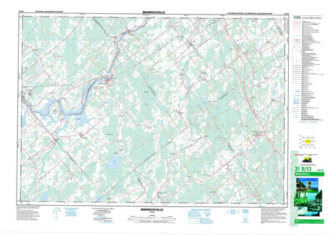
031B13 Merrickville Canada topo map, 1:50,000 scale
031B13 Merrickville NRCAN topographic map.
Includes UTM and GPS geographic coordinates (latitude and longitude). This 50k scale map is suitable for hiking, camping, and exploring, or you could frame it as a wall map.
Printed on-demand using high resolution, on heavy weight and acid free paper, or as an upgrade on a variety of synthetic materials.
Topos available on paper, Waterproof, Poly, or Tyvek. Usually shipping rolled, unless combined with other folded maps in one order.
- Product Number: NRCAN-031B13
- Parent Topo: TOPO-031B
- Map ID also known as: 031B13, 31B13
- Unfolded Size: Approximately 26" high by 36" wide
- Weight (paper map): ca. 55 grams
- Map Type: POD NRCAN Topographic Map
- Map Scale: 1:50,000
- Geographical region: Ontario, Canada
Neighboring Maps:
All neighboring Canadian topo maps are available for sale online at 1:50,000 scale.
Purchase the smaller scale map covering this area: Topo-031B
Spatial coverage:
Topo map sheet 031B13 Merrickville covers the following places:
- Gemmells Point - Ottawa - Augusta - Carleton - Dundas - Edwardsburgh - Elizabethtown - Elmsley - Grenville - Kitley - Lanark - Leeds - Marlborough - Montague - Mountain - North Elmsley - Oxford - South Elmsley - South Gower - Wolford - Bigford Drain - Murphy Drain - Patton Drain - Kilmarnock Island - Atkins Lake - Cranberry Lake - Irish Lake - Lissons Lake - Brandy Hill - Drummonds Hill - Fells Hill - Flint Hill - Newmans Hill - Carleton - Lanark - Ottawa-Carleton - United Counties of Leeds and Grenville - United Counties of Stormont, Dundas and Glengarry - Augusta - Bastard and South Burgess - Edwardsburgh - Edwardsburgh/Cardinal - Elizabethtown - Elizabethtown-Kitley - Fitzroy - Goulbourn - Huntley - Kitley - Marlborough - Montague - Mountain - North Crosby - North Dundas - North Gower - North Grenville - Osgoode - Oxford-on-Rideau - Rideau - Rideau Lakes - South Crosby - South Elmsley - South Gower - Torbolton - West Carleton - Winchester - Wolford - Canal Rideau - Lieu historique national du Canada du Blockhaus-de-Merrickville - Lieu historique national du Canada du Canal-Rideau - Merrickville Blockhouse National Historic Site of Canada - Refuge d'oiseaux de Rideau - Rideau Bird Sanctuary - Rideau Canal National Historic Site of Canada - Rideau Canal World Heritage Site - Atkinsons Creek - Barbers Creek - Brassils Creek - Charleville Creek - Dales Creek - Hutton Creek - Indian Creek - Irish Creek - Keelers Creek - Kemptville Creek - Mud Creek - Muldoons Creek - North Branch South Nation River - North Kemptville Creek - Otter Creek - Rideau Creek - Rideau River - Rideau River & Canal - Rivière Nation - Rivière Rideau - Rosedale Creek - South Branch South Nation River - South Kemptville Creek - South Kemptville Creek - South Nation River - Long Reach - Smiths Falls - Acton Corners - Actons Corners - Andrewsville - Bedell - Bell - Bells Crossing - Bishops Mills - Burritts - Burritts Rapids - Campbells Corners - Carleys Corner - Charleville - Corktown - Crystal - Domville - Domville Station - East Oxford - Easton - Eastons Corners - Garretton - Glen Smail - Groveton - Groveton Station - Heckston - Hemlock Corners - Hutchins Corners - Hyndman - Jasper - Kilmarnock - Kinch Street - McCarleys Corners - McLeanville - McReynolds - McRoberts Corner - Merrickville - Millar - Millars Corners - Newbliss - Newmanville - Nolans - Nolans Corners - North Augusta - Oxford Mills - Oxford Station - Pattersons Corners - Perrins Corners - Roebuck - Rosedale - Snowdons Corners - South Branch - South Gower - Spencerville - Story - Swan Crossing - The Island - Throoptown - Van Allens - Ventnor - Wolford Centre - Wolford Chapel - Yule - Big Marsh - Hanlan's Marsh - Huckleberry Swamp - Burritt Rapids - Merrickville-Wolford


