
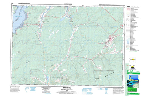
021H09 Springhill Canada topo map, 1:50,000 scale
021H09 Springhill NRCAN topographic map.
Includes UTM and GPS geographic coordinates (latitude and longitude). This 50k scale map is suitable for hiking, camping, and exploring, or you could frame it as a wall map.
Printed on-demand using high resolution, on heavy weight and acid free paper, or as an upgrade on a variety of synthetic materials.
Topos available on paper, Waterproof, Poly, or Tyvek. Usually shipping rolled, unless combined with other folded maps in one order.
- Product Number: NRCAN-021H09
- Parent Topo: TOPO-021H
- Map ID also known as: 021H09, 21H9, 21H09
- Unfolded Size: Approximately 26" high by 36" wide
- Weight (paper map): ca. 55 grams
- Map Type: POD NRCAN Topographic Map
- Map Scale: 1:50,000
- Geographical region: New Brunswick, Canada
Neighboring Maps:
All neighboring Canadian topo maps are available for sale online at 1:50,000 scale.
Purchase the smaller scale map covering this area: Topo-021H
Spatial coverage:
Topo map sheet 021H09 Springhill covers the following places:
- Boss Cove - Chignecto Bay - Cumberland Basin - Downing Cove - Pecks Cove - Boss Point - Downing Head - Hardscrabble Point - Pecks Point - Ragged Reef Point - Two Rivers Point - Ward Point - Colchester - Cumberland - Westmorland - Franklin Manor 22 - British Lake - Cleveland Lake - Forty Puzzle Lake - Harrison Lake - Long Lake - Newville Lake - Randalls Lake - Round Lake - Smiths Pond - Boars Back Ridge - Canaan Mountains - Christie Hill - Cobequid Mountains - Thundering Hill - Colchester - Cumberland - Chignecto Game Sanctuary - Joggins Fossil Cliffs World Heritage Site - Maccan River Wildlife Management Area - Site du patrimoine mondial des falaises fossilifères de Joggins - New Brunswick - Nouveau-Brunswick - Nouvelle-Écosse - Nova Scotia - Adams Brook - Atkinson Brook - Baird Brook - Barnhill River - Barren Brook - Bass River of Five Islands - Bearden Brook - Black River - Boss Brook - Broad Brook - Brown Brook - Brown Brook - Canada Creek - Chase Brook West Branch - Christie Brook - Cleveland Brook - Coal Mine Brook - Coldspring Brook - Davidson Brook - Deep Brook - East Branch Southampton River - East Brook - East River - East River of Five Islands - Elm Brook - Fishweir Brook - Five Islands River - Fordyce Brook - Forty Puzzle Brook - Fullerton Brook - Glennies Brook - Halfway Brook - Halfway River - Halliday Brook - Hancock Brook - Hannah Brook - Harrington River - Harrison Brook - Haycock Brook - Henry Brook - Hoig Brook - Holt Mill Brook - Indian Brook - John Curry Brook - Jones Brook - Kelley River - Kelley River (Mill Creek) - Kelly River - Kennedy Creek - Lake Brook - Latta Brook - Lavers Brook - Lawrence Brook - Leamington Brook - Little Forks River - Little Forks River - Little River - Maccan River - Maccan River - MacCarrons River - Mapleton Brook - McCarren Creek - Meadow Brook - Mile Brook - Mill Creek - Mills Brook - Moses Brook - Muddy Brook - North River - North Sherman Brook - O'Rourke Brook - Patton Creek - Polly Brook - Poole Creek - Porter Brook - Pugsley Brook - Pugsley Brook - Puzzle Brook - Rattling Brook - Reid Brook - River Hébert - Rutledge Brook - Sandhill Brook - Scott Brook - South Brook - South Brook - Southampton River - Sparks Brook - St. Georges Brook - Stanley Brook - Stewarts Brook - Styles Brook - Sugarwoods Brook - Taggart Brook - Tipping Brook - Welton Brook - West Brook - Whetstone Brook - Springhill - Athol - Athol Road - Athol Station - Black River Road - Chignecto - East Mapleton - East Southampton - Gilbert Mountain - Halfway River - Halfway River East - Halfway River Station - Harrison Road - Harrison Settlement - Joggins - Joggins Mines - Jubilee - Leamington - Little Forks - Lower Cove - Lower River Hebert - Lower River Hébert - Maccan - Mapleton - Millers Corner - New Canaan - Newville - Pettigrew Settlement - Ragged Reef - River Hebert East - River Hébert East - River Hebert East (Strathcona) - Rockport - Rodney - Salt Springs - Salt Springs Station - South Athol - South Brook - Southampton - Spring Hill Junction - Springhill Junction - Strathcona - Two Rivers - West Brook - Windham Hill - Bearden Barrens - Bucktagen Barrens - Jubilee Bog - Tipping Meadow - River Hebert - River Hébert


