
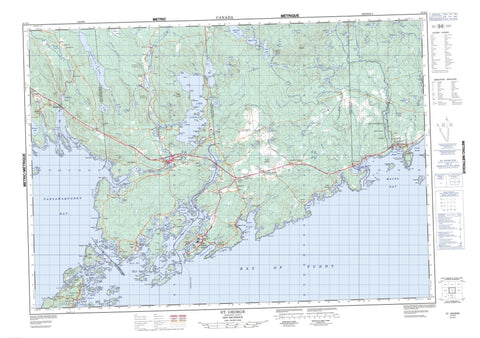
021G02 St George Canada topo map, 1:50,000 scale
021G02 St George NRCAN topographic map.
Includes UTM and GPS geographic coordinates (latitude and longitude). This 50k scale map is suitable for hiking, camping, and exploring, or you could frame it as a wall map.
Printed on-demand using high resolution, on heavy weight and acid free paper, or as an upgrade on a variety of synthetic materials.
Topos available on paper, Waterproof, Poly, or Tyvek. Usually shipping rolled, unless combined with other folded maps in one order.
- Product Number: NRCAN-021G02
- Parent Topo: TOPO-021G
- Map ID also known as: 021G02, 21G2, 21G02
- Unfolded Size: Approximately 26" high by 36" wide
- Weight (paper map): ca. 55 grams
- Map Type: POD NRCAN Topographic Map
- Map Scale: 1:50,000
- Geographical region: New Brunswick, Canada
Neighboring Maps:
All neighboring Canadian topo maps are available for sale online at 1:50,000 scale.
Purchase the smaller scale map covering this area: Topo-021G
Spatial coverage:
Topo map sheet 021G02 St George covers the following places:
- Addies Creek - Back Bay - Back Bay Harbour - Baie de Fundy - Bay of Fundy - Bay of Fundy - Beaver Harbour - Birch Cove - Black Harbour - Blacks Harbour - Bliss Harbour - Boom Cove - Browns Cove - Buckmans Creek - Bull Head Cove - Carrying Cove - Catherin Cove - Cricket Cove - Crow Cove - Crow Creek - Crow Harbour - Crow Harbour - Deadman Harbour - Deadmans Harbour - Deep Cove - Deep Cove - Devils Basin - Digdeguash Basin - Digdeguash Harbour - Fieldings Cove - Finger Bay - Fish Harbour - Fisherman Cove - Foleys Cove - Granger Cove - Green Cove - Greenlaw Cove - Greens Cove - Haggertys Cove - Hatts Cove - Hickeys Cove - Hickeys Cove - Hinds Bay - Holme Cove - Holmes Cove - Holmes Creek - Kellys Cove - Lamberts Cove - Lepreau Harbour - Letang Harbour - L'Etang Harbour - Letite Harbour - Lighthouse Cove - Lighthouse Cove - Lime Kiln Bay - Lords Cove - Maces Bay - MacNichols Cove - Magaguadavic Basin - Mathew Cove - Matthews Cove - Mill Cove - Mill Cove - Mill Cove - Negro Harbour - New River Harbour - Orange Cove - Passamaquoddy Bay - Pattersons Cove - Peggys Hole - Pintlowes Cove - Pocologan Harbour - Pond Hole - Raspberry Cove - Red Head Harbour - Reserve Cove - Sand Cove - Scotch Bay - Seeleys Basin - Seeleys Cove - Seely Basin - Seely Cove - Ship Harbour - Simmons Cove - Spragues Cove - St. Martin Bay - Stuart Cove - Stumps Cove - Sturgeon Cove - The Basin - Timber Cove - Trainors Cove - Wallace Cove - Wards Creek - Woodbury Cove - Woodland Cove - Back Beach - Canal Beach - Chitticks Beach - Cooks Beach - English Bar - Kellys Beach - MacKenzies Bar - Mahars Beach - Mascarene Shore - New River Beach - Red Beach - Sand Beach - Second Sand Beach - Sherard Beach - Barnaby Head - Birch Point - Bliss Island Point - Bobby Cooks Point - Butler Point - Canal Point - Chattys Point - Clark Point - Cranberry Point - Crazy Point - Davidson Head - Davidsons Head - Deadman Head - Deadmans Head - Deadmans Head - Drews Head - East Head - Glass Point - Goose Point - Goss Point - Gosses Point - Granger Point - Grass Point - Green Point - Greens Point - Guthrie Point - Haleys Point - Hardwood Head - Hathaway Head - Holts Point - Indian Point - Indian Point - Kings Point - Leavitts Head - Letang Head - L'Etang Head - Letang Peninsula - Lighthouse Point - Long Point - Long Point - Macs Head - Macs Head - Mascabin Point - McCarthys Point - McMahon Point - Midjik Point - Milligans Point - Orrs Point - Oven Head - Pea Point - Pocologan Point - Ragged Head - Ragged Point - Ray Point - Red Head - Seeleys Head - Seely Head - Ship Harbour Head - Simpson Head - Smith Point - Tierneys Point - Tuckers Point - Upper Green Point - West Head - West Head - White Head - Woodbury Point - Big Ovens - Doyles Passage - Doyles Passage - False Passage - Faux Passage - Irish Channel - Letete Passage - Letite Passage - Little Letete Passage - Little Letite Passage - Pendleton Passage - Pull and Be Damned Narrows - The Narrows - The Notch - The Stillwater - McCartneys Bluff - Midjic Bluff - Midjik Bluff - Red Ledges - The Bluff - Burnt Dam Falls - Crooked Falls - First Falls - Keyhole Falls - Charlotte - Lepreau - Pennfield - Saint George - Saint Patrick - West Isles - Adam Island - Bains Island - Bar Island - Barnes Island - Basaltic Island - Bean Island - Beans Island - Big Island - Bird Island - Bliss Island - Bliss Islands - Cannonball Island - Cochranes Island - Cooks Island - Crow Island - Crow Island - Deer Island - Dick Island - Dicks Island - Douglas Island - Duck Island - Eagle Island - English Island - Fish Island - Flea Island - Fothergill Islands - Fox Island - Fox Island - Frye Island - Goat Islands - Grassy Island - Green Island - Hardwood Island - Hardwood Island - Hills Island - Hog Island - Hog Island - Hoit Island - Howards Island - Hoyt Island - Hoyt Nub - Jail Island - Jameson Island - Letite Island - Little Island - Little Moose Island - Long Island - Long Island - MacDougalls Island - Macs Island - Man of War Island - Mathew Island - Matthews Island - McCann Island - McGraws Island - McMaster Island - Mink Island - Mink Island - Mohawk Island - Mole Island - Moose Island - Morans Island - Mowat Island - Munson Island - Munsons Island - New Ireland - New River Island - Nub Island - Oak Island - Oven Head Island - Pain Island - Park Island - Park Islands - Parker Island - Partridge Island - Payne Island - Peat Island - Pendleton Island - Penn Island - Pocologan Island - Salkeld Islands - Silver Island - Simpsons Island - Spruce Island - Spruce Island - Thum Cap - Thumb Island - Tub Island - Vernon Island - White Head Island - White Island - Andys Pond - Bocabec Lake - Burnt Dam Lake - Caribou Lake - Clear Lake - Coates Lakes - Cow Lake - Cranberry Lake - Crazy Lake - Daley Ponds - Dam Lake - Digdeguash Lake - Fidele Lake - Fisher Lake - Forked Lake - Fowle Lake - Goose Lake - Grassy Lake - Hawkins Lake - Hersey Lake - Horseback Lake - Hughes Lake - Jerry Pond - Johnson Lake - Knight Pond - Lake of the Hills - Lake Utopia - Lelands Lake - Lily Lake - Little Grassy Lake - Little Lake - Little Munson Lake - Little New River Lake - Little Pug Hole - Little Pughole - Long Lake - Long Lake - Loon Lakes - Love Lake - Matthews Lake - McQuade Lake - Mill Lake - Moosehorn Lake - Mud Lake - Mulherin Lake - Oliver Lake - Otter Lake - Porcupine Lake - Red Rock Lake - Roan Lakes - Rocky Lake - Roix Lake - Seeley Pond Holes - Shaw Lake - Sluice Lake - Sparks Lake - Spragues Lake - Thorne Lake - Triconia Lake - Trout Lake - Utopia Lake - Wheaton Lake - Widgeon Lake - Woodard Lake - Woodward Lake - Andersons Mountain - Big Hill - Cooks Hill - Creek Hill - Dawson Mountain - Devils Hand - Devil's Hand - Dominion Hill - Feldspar Hill - Felspar Hill - Greys Hill - Greys Mountain - Hawkins Hill - Jake Lee Mountain - Lydias Ledge - McQuirks Mountain - Monument Hill - Mount Blair - New River Mountain - Poorhouse Hill - Porcupine Mountain - Rocky Hill - Squaws Lookout - Stuart Hill - Stuart Mountain - Tomcat Hill - Troaks Hill - Troaks Mountain - New River Beach Provincial Park - Oven Head Provincial Park - Stones Rips - Black Brook - Bocabec River - Bonny River - Burns Brook - Colonel Brook - Cow Lake Brook - Cripps Stream - Dam Lake Brook - Deadwater Brook - Digdeguash River - Dowdall Meadow Brook - Gillespie Brook - Harvey Brook - Holmes Creek - Jake Lee Brook - Knights Mill Brook - Lake Anthony Brook - Lelands Creek - Lepreau River - Letang River - L'Etang River - Linton Stream - Little New River - Little Otter Brook - Little Pocologan River - Lochs Brook - Love Lake Brook - Magaguadavic River - Matthews Lake Brook - McCallum Brook - McCoy Brook - Messenett Stream - Mill Brook - Mill Creek - Mill Lake Stream - Missenett Stream - Mud Lake Brook - New River - Nightingale Brook - Orange Brook - Otter Brook - Parks Brook - Pocologan River - Red Rock Stream - Sandy Dicks Brook - Second Brook - Smelt Brook - Snake Brook - Spear Brook - The Canal - Timber Creek - Trout Brook - Trout Lake Stream - Wellington Brook - Whidden Brook - Widdens Brook - Winder Stream - Eastern Chops - Bains Ledges - Beans Ledges - Black Ledge - Black Ledge Rocks - Boat Rock - Cailiff Rocks - Chambers Rock - Charleys Ledge - Colt Rock - Cooks Shoal - Cow Rock - Crow Island Ledge - Currie Rock - Deadmans Ledge - Dry Ledge - Fish Island Ledge - Gray Mare Ledges - Haddock Ledge - Haddock Ledge - Halftide Rock - Halftide Rock - Hardwood Island Ledges - Hoopers Ledge - Little Dry Ledge - Loon Ledge - Mackerel Rock - Man of War Rock - Mare Rock - Matthews Rock - McMaster Ledge - Mohawk Ledge - Morgan Ledge - Murphys Ledge - New Lid Ledges - Parker Ledge - Pea Rock - Pomeroy Ledge - Roaring Bull - Rudder Rock - Seal Rock - Splitting Knife Ledge - The Butterballs - The Ledges - Two Hour Rock - White Horse Shoal - Whorls Rock - Yellow Rock - St. George - Back Bay - Beaver Harbour - Bethel - Bocabec - Bonny River - Bonny River Station - Breadalbane - Caithness - Canal - Crow Harbour - Deadmans Harbour - Digdeguash - Greens Point - Haggertys Cove - Hersonville - Johnson Settlement - Justasons Corner - Kerrs Ridge - Lamberts Cove - Lambertville - Letang - L'Etang - Letete - L'Etête - Letite - Lords Cove - Mascareen - Mascarene - New River - New River Beach - New River Station - Pennfield - Pennfield - Pennfield Corner - Pennfield Ridge - Pennfield Station - Pocologan - Second Falls - Seeleys Cove - Seely Cove - Stuart Town - Tunaville - Upper Letang - Utopia - Utopia Centre - Wallace Cove - Woodland - Bocabec Marsh - Dowdall Meadows - The Marsh - Blacks Harbour


