
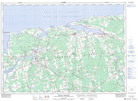
011L07 Mount Stewart Canada topo map, 1:50,000 scale
011L07 Mount Stewart NRCAN topographic map.
Includes UTM and GPS geographic coordinates (latitude and longitude). This 50k scale map is suitable for hiking, camping, and exploring, or you could frame it as a wall map.
Printed on-demand using high resolution, on heavy weight and acid free paper, or as an upgrade on a variety of synthetic materials.
Topos available on paper, Waterproof, Poly, or Tyvek. Usually shipping rolled, unless combined with other folded maps in one order.
- Product Number: NRCAN-011L07
- Parent Topo: TOPO-011L
- Map ID also known as: 011L07, 11L7, 11L07
- Unfolded Size: Approximately 26" high by 36" wide
- Weight (paper map): ca. 55 grams
- Map Type: POD NRCAN Topographic Map
- Map Scale: 1:50,000
- Geographical region: Prince Edward Island, Canada
Neighboring Maps:
All neighboring Canadian topo maps are available for sale online at 1:50,000 scale.
Purchase the smaller scale map covering this area: Topo-011L
Spatial coverage:
Topo map sheet 011L07 Mount Stewart covers the following places:
- Golfe du Saint-Laurent - Gulf of St. Lawrence - MacIntyres Creek - Pigots Creek - Savage Harbour - St. Peters Bay - Tracadie Bay - Feehans Shore - MacPhees Shore - Battery Point - Beaver Point - Cable Head - Carrs Point - Deroche Point - Doyles Point - Feehans Point - MacKinnons Point - MacPhees Point - Pigots Point - Pisquid Point - Point Deroche - Red Head - Red Point - Swallow Point - Kings - Lot 35 - Lot 36 - Lot 37 - Lot 38 - Lot 39 - Lot 40 - Lot 41 - Lot 42 - Lot 48 - Lot 51 - Lot 52 - Lot 53 - Lot 54 - Lot 55 - Lot 59 - Lot 66 - Queens - Morell 2 - Scotchfort 4 - Canavoy Island - Glenfinnan Island - Gull Island - Prince Edward Island - Rams Island - Afton Lake - Bells Pond - Bog Pond - Bowley Pond - Brazels Pond - Burges Pond - Callaghans Pond - Clarks Pond - Coffin Douglas Pond - Cranes Pond - Deroche Pond - Douglas Pond - Doyles Pond - Feehans Pond - Glenfinnan Lake - Glenfinnan Pond - Jenkins Ponds - Jordans Pond - Keefes Lake - Leards Pond - Leards Pond - Lewis Pond - Long Pond - Lot 40 Pond - MacAulays Pond - MacDonalds Pond - MacEwens Pond - MacKinnons Pond - Mooneys Pond - O'Keefe Lake - O'Keefes Lake - Pigots Pond - Pisquid Pond - Point Deroche Pond - Quigleys Pond - Reardons Pond - Schooner Pond - St. Peters Lake - Stukeley Pond - Warrens Pond - Websters Pond - Whitlocks Pond - Wiseners Pond - Cobbs Hill - Fox Hill - Haydens Hill - Moores Hill - Sand Hills - Cable Head Provincial Park - Crowbush Cove Provincial Park - Marie Provincial Park - Mount Stewart Provincial Park - O'Keefe Lake Provincial Park - Parc national du Canada de l'Île-du-Prince-Édouard - Prince Edward Island National Park of Canada - St. Peters Provincial Park - Île-du-Prince-Édouard - Prince Edward Island - Allisary Creek - Bambrick Creek - Beatons Creek - Berrigans Creek - Black Brook - Black River - Boughton River - Bristol Creek - Britain Creek - Byrnes Creek - Clark Brook - Clarks Brook - Clarks Creek - Cow Creek - Cow River - Douglas Brook - East (Hillsborough) River - East Branch Morell River - Fanning Brook - French Creek - French Fort Creek - Frenchfort Creek - Glenfinnan River - Goose River - Goose River - Graystone Creek - Hillsborough River - Hollow River - Jay Brook - Jays Brook - Johnston River - Johnstons River - Lowes Creek - MacAulays Creek - MacDougalls Creek - MacEwens Creek - MacKinnons Creek - MacLeods Creek - Marie River - McAskill River - Midgell River - Mill Cove Brook - Mill Creek - Mill Creek - Millers Creek - Morell River - Narrow Creek - Narrows Creek - Oar River - Ore River - Oyster Creek - Pine Brook - Pipers Creek - Pisquid River - Schooner Creek - Seal Creek - Silver Stream - Smelt Creek - St. Andrews Creek - St. Peters River - Tannery Creek - Trout River - West Branch Morell River - The S - 48 Road - Afton Road - Allisary - Ashton - Auburn - Augustus - Baldwin Road - Bangor - Blooming Point - Blooming Point North - Bridgetown - Bristol - Byrne Road - Byrnes Road - Cable Head - Cable Head - Cable Head East - Cable Head West - Canavoy - Cardross - Cherry Hill - Church Road - Clarktown - Corraville - Deroche Point - Dingwell - Donagh - Douglas - Dromore - Dromore West - Dundas - Dundas Centre - Dundee - Elliottvale - Elliotvale - Fanning Brook - Five Houses - Forest Hill - Forgan Hill - Fort Augustus - French Village - Glenaladale - Glenfanning - Glenfinnan - Glenroy - Goose River - Green Meadows - Greenwich - Head of Cardigan - Head of Hillsborough - Johnston River - Johnstons River - Leard Mills - Leards Mill - Lorne Valley - Lot 40 - Lot 40 Station - Maple Hill - Maple Leaf - Marie - Martinvale - McCannell Wharf - Midgell - Milburn - Monaghan - Morel - Morell East - Morell Rear - Mount Hope - Peake Station - Peakes - Peakes Road - Pisquid - Pisquid West - Point Deroche - Primrose - Riverton - Ruskin - Savage Harbour - Scotchfort - Sinnott Road - Southampton - St. Andrews - St. Patrick Road - St. Peter - St. Peters Harbour - St. Teresa - St. Teresa West - Strathcona - Tarantum - Tenmile House - Tracadie - Tracadie Cross - Upton - Watervale - Webster Corner - Websters Corner - West St. Peters - Windon - Indian Marsh - Central Kings - Lorne Valley - Morell - Mount Stewart - St. Peters - St. Peters Bay


