
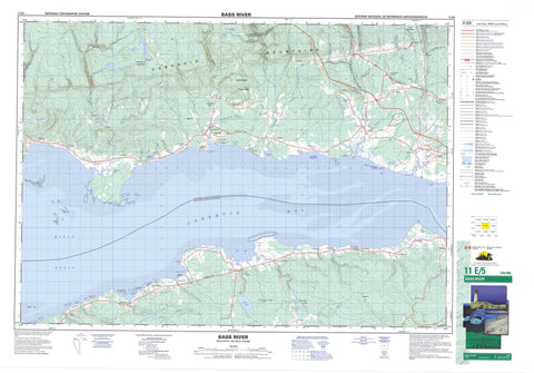
011E05 Bass River Canada topo map, 1:50,000 scale
011E05 Bass River NRCAN topographic map.
Includes UTM and GPS geographic coordinates (latitude and longitude). This 50k scale map is suitable for hiking, camping, and exploring, or you could frame it as a wall map.
Printed on-demand using high resolution, on heavy weight and acid free paper, or as an upgrade on a variety of synthetic materials.
Topos available on paper, Waterproof, Poly, or Tyvek. Usually shipping rolled, unless combined with other folded maps in one order.
- Product Number: NRCAN-011E05
- Parent Topo: TOPO-011E
- Map ID also known as: 011E05, 11E5, 11E05
- Unfolded Size: Approximately 26" high by 36" wide
- Weight (paper map): ca. 55 grams
- Map Type: POD NRCAN Topographic Map
- Map Scale: 1:50,000
- Geographical region: Nova Scotia, Canada
Neighboring Maps:
All neighboring Canadian topo maps are available for sale online at 1:50,000 scale.
Purchase the smaller scale map covering this area: Topo-011E
Spatial coverage:
Topo map sheet 011E05 Bass River covers the following places:
- Clement Cove - Cobequid Bay - Halfmoon Cove - King Creek - King Creek - Minas Basin - Moose Cove - Noel Bay - Shad Creek - Little Dyke Beach - Lower Debert Beach - Portapique Beach - Burntcoat Head - Cape Tenny - Corbett Point - Economy Point - Lighthouse Point - Noel Head - Salter Head - Spencer Point - Spencers Point - Colchester - Cumberland - Hants - Austin Lake - Beaver Ponds - Economy Lake - Gamble Lake - Gamble Lake Pond - John Hennigar Lake - Little Dyke Lake - Louis Crowe Lake - Maitland Millpond - McLauchlin Lake - McLaughlin Pond - Newton Lake - Newton Pond - Noel Lake - Round Lake - Toad Lake - Birch Hill - Cobequid Mountains - Creelman Hill - Folly Mountain - MacLellan Mountain - Portapique Mountain - Colchester - Cumberland - East Hants - Anthony Provincial Park - Bass River - Bear Brook - Beaver Brook - Beaver Meadow Brook - Beech Brook - Bills Brook - Black Brook - Bulmer Brook - Callaghan Brook - Campbell Brook - Carr Brook - Carrs Brook - Cayley Brook - Chain Lake Brook - Chain Lake Stream - Cook Brook - Corbett Brook - Crowe Brook - Cumberland Brook - Dead Horse Brook - Debert River - Densmore Brook - Doyle Brook - East Branch Economy River - East Branch Folly River - East Branch Stirling Brook - East Economy River - East Folly River - East Noel River - East River - East River of Five Islands - Economy River - Etter Brook - Five Houses Brook - Five Mile River - Fivemile River - Folly River - Gamble Brook - Great Village River - Hill Brook - Jackson Brook - King Creek - King Creek Brook - Lattie Brook - Latties Brook - Little Bass River - Martin Brook - Matheson Brook - McCurdy Creek - McElman Brook - McElmon Brook - Mile Brook - Mill Brook - Miller Brook - Mines Brook - Moore Brook - Moose Brook - Moose Brook - Mungo Brook - Murphy Brook - Noel River - Peleg Brook - Peppard Brook - Pollys Brook - Portapique River - Rennie Brook - Robinson Brook - Rockland Brook - Rockland River - Saltspring Brook - Selma Brook - Selmah Brook - Shad Brook - Shad Brook - Shad Creek Brook - Spencer Brook - Sterling Brook - Stirling Brook - Tennycape River - Tunnel Brook - Weatherbe Brook - Weatherby Brook - West Bass River - West Branch Economy River - West Economy River - West McElman Brook - West McElmon Brook - West Tennycape River - Wetherbe Brook - Wilcox Brook - Brick Kiln - Brick Kiln Ledges - Sloop Rocks - Walton Bar - White Rock - Bass River - Birch Hill - Burntcoat - Carrs Brook - Cove Road - Densmores Mills - East Mines Station - East Noel - East Village - East Walton - Economy - Economy Point - Edgewood - Five Houses - Folly Mountain - Gerrish Valley - Glenholme - Gormanville - Great Village - Hennigar - Highland Village - Hoegs Corner - Kings Rest - Kings' Rest - Kings' Rest - Lake Road - Little Bass River - Little Dyke - Londonderry - Londonderry Station - Lornevale - Lower Debert - Lower Economy - Lower Selma - Lower Selmah - Maitland - Maple Grove - Minasville - Montrose - Moose Brook - Noel - Noel Shore - Northfield - Pleasant Hills - Portapique - Portapique Mountain - Probert - Saints Rest - Saints' Rest - Scrabble Hill - Selma - Selmah - Stirling Brook - Tennycape - Upper Bass River - Upper Economy - West Montrose - Beaver Meadow - Joe Crowe Meadow - Lyons Marsh - Northfield Bog


