
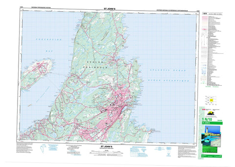
001N10 St John s Canada topo map, 1:50,000 scale
001N10 St John s NRCAN topographic map.
Includes UTM and GPS geographic coordinates (latitude and longitude). This 50k scale map is suitable for hiking, camping, and exploring, or you could frame it as a wall map.
Printed on-demand using high resolution, on heavy weight and acid free paper, or as an upgrade on a variety of synthetic materials.
Topos available on paper, Waterproof, Poly, or Tyvek. Usually shipping rolled, unless combined with other folded maps in one order.
- Product Number: NRCAN-001N10
- Parent Topo: TOPO-001N
- Map ID also known as: 001N10, 01N10, 1N10
- Unfolded Size: Approximately 26" high by 36" wide
- Weight (paper map): ca. 55 grams
- Map Type: POD NRCAN Topographic Map
- Map Scale: 1:50,000
- Geographical region: Newfoundland and Labrador, Canada
Neighboring Maps:
All neighboring Canadian topo maps are available for sale online at 1:50,000 scale.
Purchase the smaller scale map covering this area: Topo-001N
Spatial coverage:
Topo map sheet 001N10 St John s covers the following places:
- Beachy Cove - Big Cove - Big Freshwater Cove - Blackhead Bay - Bobbies Cove - Bottle Cove - Boulders Cove - Broad Cove - Broad Cove - Bull Cove - Cantwells Cove - Cape Bay - Caplin Cove - Chimney Cove - Chimney Cove - Church Cove - Conception Bay - Cow Cove - Crane Gulch - Cuckold Cove - Cuckolds Cove - Cuckolds Cove - Dark Hole Cove - Dead Mans Cove - Deadmans Bay - Dogs Hole - Doyles Cove - Flat Rock Cove - Frederick Cove - Freshwater Bay - Freshwater Cove - Gallows Cove - Gladneys Arm - Goat Cove - Green Gulch - Green Head Cove - Gunners Cove - Hay Cove - Herring Cove - Hole in the Head - Jackmans Cove - Jessie Codners Hole - Jobs Cove - Jones Cove - Jones Cove - Kelby Cove - Kings Cove - Klondyke Gulch - Knights Arm - Knights Cove - Little Cove - Little Freshwater Cove - Little Gallows Cove - Little Jones Cove - Logy Bay - Long Harry Cove - Long Pond Gut - Lower Big Cove - Lower Herring Cove - Lower Horse Cove - Mannings Cove - Middle Cove - Murdering Gulch - Murphys Gulch - North Hole - Number Two Cove - Ochre Cove - Ochre Pit Cove - Outer Cove - Paper Cove - Peggys Bag - Portugal Cove - Pound Gulch - Powers Cove - Pulpit Cove - Quidi Vidi Harbour - Ragged Head Cove - Red Head Cove - Redmans Cove - Robin Hood Bay - Rolls Cove - Ryans Cove - Sailing Gulch - Sam Cove - Sandy Cove - Saunders Cove - Seals Cove - Ship Cove - Shooting Point Cove - Skerries Bight - Sleepy Cove - Small Point Cove - Smooth Gulch - Sought Bight - South Bight - South Hole - Southwest Arm - Spanish Gulch - Spear Bay - Spout Cove - St. John's Bay - St. John's Harbour - St. Thomas Cove - Stiles Cove - Tappers Cove - The Basin - The Bight - The Circle - The Skerries - Tobias Gulch - Topsail Bight - Topsail Cove - Tor Bay - Torbay Bight - True Blue Gulch - Upper Big Cove - Upper Herring Cove - Upper Herring Gulch - Watsons Cove - Whalens Cove - Windy Cove - Woody Cove - Big Beach - Chamberlains Beach - Lance Cove Beach - Long Pond Beach - Manuels Beach - The Beach - Topsail Beach - Whalens Beach - Abrams Head - Anchor Point - Avalon Peninsula - Birchy Point - Black Head - Blackhead - Blast Hole Point - Blow Me Head - Bradburys Point - Brocks Head - Cahill Point - Cape Spear - Chamberlains Head - Church Cove Point - Cliff Point - Codfish Point - Cuckold Head - Dark Hole Head - Devils Point - Eastern Head - Ferry Point - Flat Rock Point - Flowers Point - Foxtrap Head - Frosts Island - Grassy Point - Gravel Head - Grebes Nest Point - Greeleys Point - Gull Island North Head - Gull Island South Head - Knights Arm - Lance Cove Head - Long Harry Point - Lower High Point - Manuels Head - Newells Point - North Head - North West Point - Ore Head - Patch Point - Peggys Leg - Peters Point - Piccos Point - Polls Head - Pulpit Head - Ragged Head - Red Head - Redcliff Head - Redmans Head - Redmans Head - Redmonds Head - Sailing Point - Sculpin Point - Sculpin Point - Sculpins Point - Ship Cove Point - Small Point - Small Point - Small Point - Snagge Point - South Head - Spriggs Point - Sugarloaf Head - Swiles Head - The Beamer - The Bill of the Cape - The Gaze - The Lookout - The Parlor - The Peg - Thistles Point - Topsail Head - Torbay Point - Upper Grebes Nest Point - Upper High Point - Wester Point - Wester Point - Whalens Head - Whalens Point - Bell Island Tickle - The Narrows - The Narrows - Mount Pearl - St. John's - Black Cliff - Blow Me Down - Grebes Nest - Red Cliff - Soldiers Gulch - The Chalks - The Flats - White Cove Cliff - The Spout - Bell Island - Burnt Island - Fishing Island - Little Bell Island - Sandy Beach - Skerries Islands - Turfys Island - Adams Pond - Axes Pond - Barking Kettle Pond - Bauline Long Pond - Bauline Rocky Pond - Beachy Cove Ponds - Beaver Pond - Beaver Pond - Bentley Pond - Big Pond - Big Punch Bowl Pond - Big Three Corner Pond - Birch Hill Gully - Blast Hole Ponds - Branscombes Pond - Brazil Pond - Bremigens Pond - Brocks Head Pond - Brocks Pond - Bubble Pond - Burtons Pond - Butlers Pond - Butlers Pond - Chamberlains Pond - Chidley Pond - Church Pond - Clements Pond - Cochrane Pond - Cove Pond - Crow Head Pond - Deadmans Pond - Duck Pond - Duck Pond - Duck Pond - Fagans Marsh - First Gully - Freshwater Bay Pond - Freshwater Pond - Frog Pond - Funnell Pond - Gallows Cove Pond - Gallows Cove Ponds - Georges Pond - Georges Pond - Goose Pond - Goughs Gully - Great Pond - Grog Pond - Gull Pond - Gully Pond - Half Moon Pond - Handy Pond - Healeys Pond - Herring Cove Pond - Hickeys Pond - Hogans Pond - Hughs Pond - Inside Gully - Inside Pond - Island Pond - John Howards Pond - Johnny O'Learys Gullies - Johnny O'Learys Gullys - Jones Pond - Juniper Ponds - Kennys Pond - Kents Pond - Lance Cove Pond - Lawlors Gully - Leamys Ponds - Left Pond - Little Duck Pond - Little Gallows Cove Pond - Little Gully - Little Herring Cove Pond - Little Oliver Pond - Little Powers Pond - Little Punch Bowl Pond - Long Gully - Long Pond - Long Pond - Long Pond - MacWilliams Gully - Middle Pond - Middle Pond - Middle Rocky Pond - Middle Three Island Pond - Miles Pond - Millers Pond - Mitchells Pond North - Mitchells Pond South - Moon Pond - Moriartys Pond - Mundy Pond - Murrays Pond - Nearys Pond - Neils Pond - Nevilles Pond - Newfound Pond - North Pond - North Three Island Pond - Northeast Pond - Northwest Pond - Ocean Pond - Octagon Pond - Olivers Pond - Outside Gully - Outside Pond - Oxen Pond - Paddys Pond - Parkers Pond - Petty Harbour Long Pond - Peytons Pond - Piccos Pond - Piccos Pond South - Pond on the Head - Pouch Cove Gully - Powers Pond - Punch Mile Gullies - Quidi Vidi Lake - Robins Pond - Rocky Pond - Rocky Pond - Rogers Gullies - Rogers Tilt Pond - Round Pond - Round Pond - Round Pond - Ryalls Pond - Second Gully - Sheens Pond - Sheep Pen Gully - Shoe Cove Pond - Skerries Pond - Soldiers Brook Pond - Soldiers Pond - South Pond - Stick Pond - Stick Pond - Stickles Pond - Sugarloaf Pond - Three Arm Pond - Three Island Pond - Tommy Whites Pond - Topsail Pond - Topsail Round Pond - Torbaymans Pond - Triangle Pond - Virginia Lake - Watts Pond - West Dam Pond - Western Island Pond - Western Pond - Western Round Pond - Whiteway Pond - Wigmore Pond - Williams Pond - Windsor Lake - Withrod Pond - Dominion Pier - Scotia Pier - Canadian Forces Station St. John's - Station des Forces canadiennes St. John's - Beachy Cove Hill - Big Hill - Birch Hill - Black Head - Blast Hole Hill - Boulder Highland - Bremigens Ridge - Buckleys Hill - Cape Hill - Church Cove Hill - Coles Hill - Crown Hill - Deadmans Bay Hill - Dogberry Hill - Eastern Ridge - Firewood Hill - Flagstaff Hill - Franks Hill - Frenchmans Ridge - Gibbett Hill - Hel Saal - Hells Al - Kenmount Hill - Knobby Hill - Lockeys Hill - Lokeys Hill - Middle Pond Ridge - Moon Pond Ridge - Morriseys Ridge - Mother Allans Rock - Mount Ken - Mount Scio - Neils Pond Ridge - Nevilles Hill - Paradise Hill - Piccos Ridge - Pipers Stock Hill - Plowed Hill - Princes Lookout - Purcells Ridge - Raymonds Beard Hill - Robbins Hill - Saddle - Signal Hill - Skinners Tolt - Snagge Hill - South Side Hills - Split Rock - St. Andrews Hill - St. Patricks Hill - The Lookout - The Pulpit - Thornes Hill - Tolt - Topsail Highlands - Topsail Hill - Torbay Southern Head - Torbaymans Lookout - Tuckers Hill - Watts Ridge - Western Ridge - White Hills - White Hills - Wickhams Ridge - Wireless Hill - St. John's Metropolitan Area - Bowring Park - Cape Spear National Historic Site of Canada - Lieu historique national du Canada de Signal Hill - Lieu historique national du Canada du Cap-Spear - Marine Drive Provincial Park - Middle Cove Provincial Park - Newfoundland T'Railway Provincial Park - Signal Hill National Historic Site of Canada - Topsail Beach Provincial Park - Raines Plains - Bauline Brook - Bauline River - Beachy Cove Brook - Big River - Black Brook - Blast Hole Pond River - Broad Cove River - Cartys Stream - Coakers River - Conway Brook - Cross Brook - Drukens River - Flings Brook - Fowlers Brook - Foxtrap River - Goat Cove Brook - Half Moon Brook - Horse Cove Brook - Island Pond Brook - Kellys Brook - Kennedys Brook - Kitty Gauls Brook - Leamys Brook - Learys Brook - Main Brook - Main River - Manuels River - Miles Brook - Millers Pond River - Murrays Pond River - North Pond Brook - Northeast Pond River - Outer Cove Brook - Piccos Brook - Pincombes Brook - Pouch Cove Brook - Pouch Cove Brook West - Rainbow Gullies - Rennie's River - Rocky Brook - Shoe Cove Brook - Soldiers Brook - South Brook - Spear Bay Brook - Steadywater Brook - Stick Pond Brook - Topsail River - Triangle Brook - Virginia River - Voiseys Brook - Waterford River - Yellow Marsh Stream - Anchor Rock - Blackhead Bank - Boulder Rock - Cat Rock - Chain Rock - Cordelia Deeps - Cow and Calf Ledge - Ellinor Rock - Founder Rock - Gull Rocks - Halfway Rock - Island Rock - Island Rock - Little Pancake - Merlin Rock - Old Haman Rock - Old Harry - Pancake Shoal - Petty Harbour Ledges - Pot Rock - Prosser Rock - Redhead Rock - Ruby Rock - Seal Rock - Shag Rocks - Sly Boots - Spar Rock - St. Georges Leads - Tantam Rock - Tantam Shoals - The Chest - The Divers - The Rags - The Riband - The Whale - Tinker Bank - Tinker Rock - Vestal Rock - Washballs - Whaleback Rock - White Rock - Winter Bank - Yellow Moll - Bauline - Conception Bay South - Flatrock - Glendale - Logy Bay-Middle Cove-Outer Cove - Mount Pearl Park-Glendale - Paradise - Paradise-St. Thomas - Portugal Cove-St. Philip's - Portugal Cove-St. Phillips-Hogan's Pond - Pouch Cove - Torbay - Wabana - Bally Haly - Bell Island - Bell Island Front - Birchy Nap - Blackhead - Blackhead Road - Cahill Point - Chamberlains - Churchill Park - Codner - Donovans - East Meadows - Evergreen Village - Flatrock - Fort Townshend - Fort William - Foxtrap - Georgestown - Glendale - Glenridge Crescent - Glenvilla Court - Greeleytown - Hogan's Pond - Hoylestown - Irvine - Kilbride - Lance Cove - Logy Bay - Long Pond - Manuels - Middle Cove - Mount Cashel - Mount Pearl Park - Newton - North Pond Heights - Otterbury - Outer Cove - Peachytown - Penetanguishene - Pleasantville - Portugal Cove - Quidi Vidi - Rabbit Town - Ricketts Bridge - Saint Annes Industrial Park - Sand Pits - Shea Heights - Shoe Cove - St. Philip's - St. Phillips - St. Phillip's - St. Thomas - Talcville - Tanguishene - The Battery - The Front - The Green - Thorburn Road - Topsail - Virginia Park - Waterford Bridge - Wedgewood Park - West Mines - Windsor Heights - Wishingwell Park - Woodstock - Big Drake - Crane Gulch - Freshwater Valley - Kellys Brook - The Scrape - Bakeapple Marsh - Berry Marsh - Bill Kennedys Bog Hole - Black Marsh - Cartys Marsh - Deadmans Pond - Deer Marsh - Featherbed Marsh - Flannery Barren - Fogartys Meadows - Frenchmans Marsh - Grassy Marsh - Holes In The Marsh - Hummocky Marsh - Island Pond Marsh - Juniper Marsh - Juniper Stump - Knights Marsh - Long Run Bog - Moores Garden - Pouch Cove Marsh - Round Juniper Marsh - Spring Well - Summer Marsh - The Level - Three Pond Barrens - Walshs Marsh - Yellow Marsh - Flat Rock


