
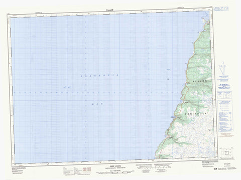
001M01 Ship Cove Canada topo map, 1:50,000 scale
001M01 Ship Cove NRCAN topographic map.
Includes UTM and GPS geographic coordinates (latitude and longitude). This 50k scale map is suitable for hiking, camping, and exploring, or you could frame it as a wall map.
Printed on-demand using high resolution, on heavy weight and acid free paper, or as an upgrade on a variety of synthetic materials.
Topos available on paper, Waterproof, Poly, or Tyvek. Usually shipping rolled, unless combined with other folded maps in one order.
- Product Number: NRCAN-001M01
- Parent Topo: TOPO-001M
- Map ID also known as: 001M01, 01M1, 1M1, 01M01, 1M01
- Unfolded Size: Approximately 26" high by 36" wide
- Weight (paper map): ca. 55 grams
- Map Type: POD NRCAN Topographic Map
- Map Scale: 1:50,000
- Geographical region: Newfoundland and Labrador, Canada
Neighboring Maps:
All neighboring Canadian topo maps are available for sale online at 1:50,000 scale.
Purchase the smaller scale map covering this area: Topo-001M
Spatial coverage:
Topo map sheet 001M01 Ship Cove covers the following places:
- Angels Cove - Angel's Cove - Back Cove - Ballast Cove - Big Cove - Big Gull Rock Cove - Carols Cove - Dog Brook Cove - Doyles Cove - Glennons Cove - Gooseberry Cove - Great Barasway - Halfway Brook Cove - Harry Cove - Ice House Cove - Little Barasway Cove - Little Cove - Little Gull Rock Cove - Little Meadow Cove - Long Point Cove - Miners Cove - Patrick's Cove - Placentia Bay - Placentia Road - Rocky Cove - Seal Rocks Cove - Ship Cove - Shoe Cove - Stoney House Bight - Valley of Diamonds - Cape Shore - Harry Cove Beach - Kittys Beach - Avalon Peninsula - Black Point - Caroline Browns Point - Down Point - Grassy Point - Grassy Point - Green Point - Grepes Nest - Halfway Gully Point - Little Meadow Point - North Point - North Point of Angels Cove - North Point of Gooseberry - Norther Point - Otter Rub Point - Point Verde - Seal Point - Shoal Point - Souther Point - Stake Point - Sunker Point - Tommy Doyles Point - Wester Point - Wester Point of Gooseberry - Woody Point - Conways Fill - Big Falls - Big Tuck - Doyles Tuck - Beachy Pond - Big Rock Pond - Corcorans Pond - Dry Pond - Easter Brook Ponds - Feeders - Gate Brook Pond - Glennons Cove Pond - Goose Pond - Great Barasway Pond - Halfway Brook Pond - Hare Hill Pond - Inside Gully - James Brennans Gully - Lily Pond - Little Meadow Pond - Long Jims Hay - Lookout Pond - Patricks Cove Pond - Point Verde Pond - Round Pond - The Downs - Angels Lookout - Bunk Peak - Great Barasway Lookout - Hare Hill - High Hill - Hill of the Gully - Patricks Lookout - Platform Hills - Ship Cove Dry Hill - Ship Cove Lookout - Sugarloaf - Sugarloaf Peak - Tommy Doyles Hill - Gooseberry Cove Provincial Park - Angels Cove Brook - Beaver Pond Gully - Big Brook - Branch River - Bulgers Feeder - Coxs of Hay Gully - Dog Brook - East Brook - Easter Brook - Eastern Pinnacle Gully - Feeders River - First Gully - Gate Brook - Glennons Cove River - Halfway Brook - Halfway Brook - Halfway Gully - Hare Hill Gully - Harry Cove River - James Brennans River - Leap Brook - Little Barachois River - Little Barasway River - Little Brook - Little Meadow River - Michael Brennans Gully - Mid Pinnacle Gully - Middle Brook - North Brook - Patricks Cove Brook - Powder Horn Brook - Seal Rocks River - Second Gully - Ship Cove Brook - South Brook - South Brook - Souther Brook - Souther Tuck Gully - Southern Brook - Stoney House Brook - Viscount Bridge Gully - Western Pinnacle Gully - False Girdle - Gibraltar Rock - Girdle Rock - Goose Shoal - Lower Big Shoal - Merasheen Bank - Patrick's Rock - South Rock - Southern Ridge - Upper Big Shoal - Virgin Rocks - Angels Cove - Angel's Cove - Gooseberry Cove - Great Barasway - Little Barasway - Patrick's Cove - Patrick's Cove-Angels Cove - Point Verde - Ship Cove - Stoney House - Hells Drook - Easter Brook Marshes - Gooseberry Forks - Little Meadow Mash - Patricks Cove Fork


