Free Shipping on map orders over $300
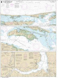
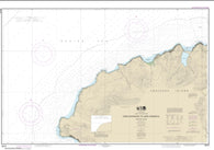
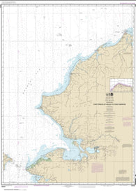
Cape Henry to Currituck Beach Light (12207-24) by NOAA
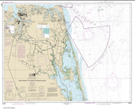
Cape Henry to Pamlico Sound, Including Albemarle Sd.; Rudee Heights (12205-34) by NOAA
Cape Herlacher To Matha Strait (NGA-29005-7) by National Geospatial-Intelligence Agency
CAPE HOOKER TO COULMAN ISLAND (14909) by Land Information New Zealand (LINZ)
Cape Hooper and Approaches by Canadian Hydrographic Service
Cape Hooper to Arguyartu Point Including Ekalugad Fiord by Canadian Hydrographic Service
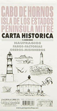
Cape Horn, Isla de los Estados, Peninsula Mitre, Historical Map by Zagier y Urruty
Cape Hurd to/a Lonely Island by Canadian Hydrographic Service
Cape Hurd to/a Tobermory and/et Cove Island by Canadian Hydrographic Service
Cape Ikolik to Cape Kuliuk (16598-10) by NOAA
Cape Jameson to/au Cape Fanshawe by Canadian Hydrographic Service
Cape Kakkiviak to/a Duck Islands by Canadian Hydrographic Service
CAPE KARIKARI TO CAPE BRETT (512) by Land Information New Zealand (LINZ)
Cape Kavrizhka to Cape Cheerful (16518-7) by NOAA
Cape Kiglapait to/a Khikkertarsoak North Island by Canadian Hydrographic Service
Cape LaHave to/a Liverpool Bay by Canadian Hydrographic Service
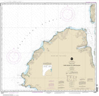
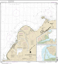
Cape Lookout to New River (11543-24) by NOAA
Cape LookoutBogue Sound to Drum Inlet Inshore Fishing Map
Cape Lyon to/a Tinney Point by Canadian Hydrographic Service
Cape Manning to Borden Island by Canadian Hydrographic Service
Cape May Fishing Map Cape May to Atlantic City
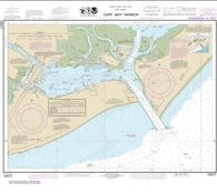
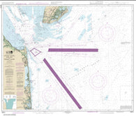
Cape May Harbor (12317-32) by NOAA
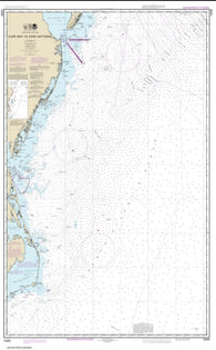
Cape May to Cape Hatteras (12200-51) by NOAA
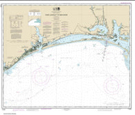
Cape May to Fenwick Island (12214-49) by NOAA
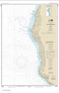
Cape Mendocino and vicinity (18623-12) by NOAA
Cape Mercy to Kangeeak Point by Canadian Hydrographic Service
Cape Mills to/a Cape Rammelsberg by Canadian Hydrographic Service
Cape Norton Shaw to Cape MClintock by Canadian Hydrographic Service
Cape Norvegia To Riiser-Larson Peninsula (NGA-29025-3) by National Geospatial-Intelligence Agency
CAPE PALLISER TO KAIKOURA PENINSULA (62) by Land Information New Zealand (LINZ)
Cape Pine to/a Cape St. Marys by Canadian Hydrographic Service
Cape Pine to/a Renews Harbour by Canadian Hydrographic Service
Cape Prince of Wales to Davies Island by Canadian Hydrographic Service
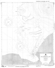
Cape Prince of Wales to Pt. Barrow (16005-10) by NOAA
Cape Race to/a Cape Freels by Canadian Hydrographic Service
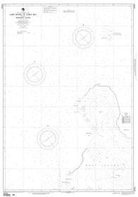
Cape Ramonzof to St. Michael; St. Michael Bay; Approaches to Cape Ramanzof (16240-10) by NOAA
CAPE REINGA TO MANUKAU HARBOUR (42) by Land Information New Zealand (LINZ)
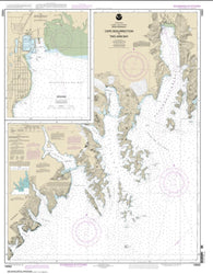
Cape Resurrection to Two Arm Bay; Seward (16682-17) by NOAA
Cape Royds To Hut Point (NGA-29322-3) by National Geospatial-Intelligence Agency
Cape Royds To Lewis Bay Including Beaufort Island (NGA-29281-1) by National Geospatial-Intelligence Agency