Free Shipping on map orders over $300 - Prices in US$
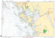
OSLOFJORDEN, FULEHUK-FILTVET-RØDTANGEN (3) by Kartverket
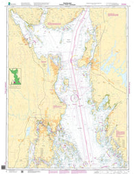
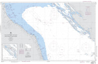
OSLOFJORDEN, FÆRDER-HVALER-HALDEN (1) by Kartverket
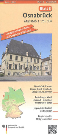
Osnabrück 1:250 000, blatt 8
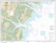
Ossabaw and St. Catherines Sounds (11511-18) by NOAA
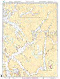
OSTERFJORDEN OG SØRFJORDEN (119) by Kartverket
Österreich = Austria = Autriche
Österreich Organisation, 1:500.000, Poster = Austria organization, 1:500,000, wall map
Österreich Organisation, 1:500.000, Poster metallbestäbt = Austria organization, 1:500,000, wall map metal bars wall map
Österreich Organisiation - A3, Planokarte 1:1.300.000 = Austria Organization - A3, flatcarte 1:1,300,000
Österreich physisch, 1:500.000, Poster = Austria physical, 1:500,000, wall map
Österreich physisch, 1:500.000, Poster metallbestäbt = Austria physical, 1:500,000, wall map metal bars
Österreich Postleitzahlen, 1:500.000 = Austria postcodes, 1:500,000
Österreich Postleitzahlen, Poster 1:500.000, Metallbestäbt in Rolle = Austria postcodes, wall map 1:500,000, metal bars
Österreich Postleitzahlen, Poster 1:500.000, Plano in Rolle = Austria postcodes, wall map 1:500,000, flat
Österreich Verwaltung - A3, Planokarte 1:1.300.000 = Austria administrative - A3, flatcarte 1:1,300,000
Österreich Verwaltung, 1:500.000, Poster = Austria administrative, 1:500,000, wall map
Österreich Verwaltung, 1:500.000, Poster metallbestäbt = Austria administrative, 1:500,000, wall map metal bars wall map
Österreich, Straßenkarte 1:300.000, Großformat, Poster = Austria, street map 1:300,000, large scale, wall map
Österreich-set : autokartenset, 1:250 000 = Austria-set : roadmap set, 1:250 000 = Autriche-set : set de cartes routières, 1:250 000 = Austria-set : set di carte stradali, 1:250 000
Österreich-Ungarn 1890, 1:1,500,000., Historische Karte = Austria-Hungary 1890, 1:1.500,000, historical map
Österreich-Ungarn 1890, Historische Karte, Poster 1:1,500,000. = Austria-Hungary 1890, historical map, wall map 1:1.500,000
Österreichische Weitwanderwege, Wanderkarte 1:800.000, freytag & berndt = Austrian long -distance hiking trails, hiking map 1:800,000
Osterzgebirge Hiking Map & Guide
Ostfriesland - Münsterland - Bremen, road map 1:150,000, sheet 3
Ostfriesland, Rad- und Freizeitkarte 1:75.000, freytag & berndt, RK 0136 = East Frisia, bike and leisure map 1:75,000 RK 0136
Ostkarawanken and Steiner Alpen, #47 by Freytag-Berndt und Artaria
Östlicher Taunus Hiking Map & Guide
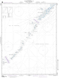
Ostrov Paramushir To Ostrov Simushir (NGA-96024-3) by National Geospatial-Intelligence Agency
Ostrov Simushir To Ostrov Kunashir (NGA-96020-4) by National Geospatial-Intelligence Agency
Oststeiermark Mittleres Burgenland by Freytag-Berndt und Artaria
Oswego County, New York by Jimapco
Oswego Harbor (14813-22) by NOAA
Otago-South Canterbury, New Zealand, Rural Roads Topographic Map by Kiwi Maps
Otago-Southland Rural Road Map
Otago-Southland Rural Roads, New Zealand, Topographic Map by Kiwi Maps
Otago-Sth Canterbury Rural Road Map
Otaru City Map
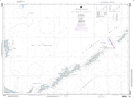
Otok Drvenik Mali To Otok Susak And Porto Dascoli To Porto Corsini (NGA-54115-3) by National Geospatial-Intelligence Agency
Otok Lastovo To Otok Zirje And Punta San Francesco To Ancona (NGA-54105-3) by National Geospatial-Intelligence Agency
Ötscherland, hiking, bike and leisure map 1:50,000 WK 0031