
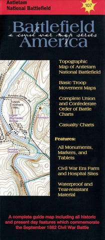
Antietam National Battlefield
Fought in September of 1862, Antietam was tactically a draw, but strategically, was a great Union victory. Soon after the Battle of Antietam, President Lincoln issued the Emancipation Proclamation. England and France, who were near to official recognition of the Confederacy, drew back. September 17, 1862 was the single bloodiest day of the Civil War, with Union losses numbering 12,410, and Confederate losses at 10,700.
Map Features:
The large topo map features the location of 96 monuments and 215 markers and tablets. Trails, historic farms and hospitals, and modern and historic tree lines are also featured. An Order of Battle Chart as well as other index maps are also included.
- Product Number: THG_ANTIETAM_23
- Reference Product Number: - None -
- ISBN: 9781883271060
- Date of Publication: 4/1/2023
- Folded Size: 9.45 inches high by 3.94 inches wide
- Unfolded (flat) Size: 18.11 inches high by 24.41 inches wide
- Map format: Folded
- Map type: Trade Maps - Historical
- Geographical region: United States
- Geographical subregion: Maryland


