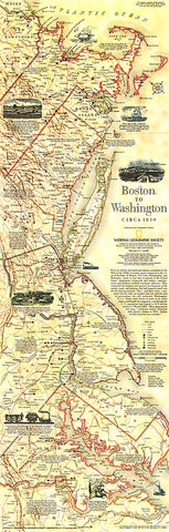
1830 Boston To Washington Circa 1830 Map
This historical map is based on plates drafted by Henry Schenk Tanner which cover the Atlantic Coast from Boston to Washington, D.C. Features a variety of historical notes and illustrations. Published in July 1994 as half of a two–map set with Boston to Washington, Megalopolis.
- Product Number: PODHNG_US_BOS_WAS_30
- Reference Product Number: 2321297M
- ISBN: - None -
- Date of Publication: ###############################################################################################################################################################################################################################################################
- Unfolded (flat) Size: 31.25 inches high by 10 inches wide
- Map format: Wall
- Map type: Trade Maps - Wall Art
- Geographical region: United States