
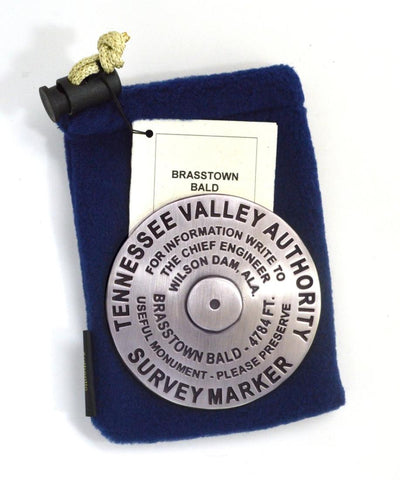
Brasstown Bald, Georgia paperweight
3 1/4 inch diameter
Cast in fine pewter
Felt backing
With soft fleece pouch
In clear-vinyl covered box
PLACE NAME: Brasstown Bald
ELEVATION: 4,784 ft.
COORDINATES: N34° 52 27 W83° 48 38
LOCATION: Towns/Union Counties, Georgia, USA
MARKERSLEUTH PHOTO CONTRIBUTORS: Sheila Edmunds, Harry Ireland, Paul Ireland, Teresa & Don Morris, Van & Dorothy Criswell, and Jennifer Ernst
Brasstown Bald is Georgias highest elevation, rising 4784 feet above sea level. It is part of the Blue Ridge Mountain chain of the Appalachian Mountain range. The summit is crowned with a stone tower and observation deck from which four states - Georgia, Tennessee, North Carolina, and South Carolina - are visible on a clear day. Originally a project of the Civilian Conservation Corps the present site was completed in 1965. To see the marker, visitors may ask the friendly ranger for access. It is located behind a locked gate at the tower’s base.
- Product Number: GSU_PW_BRASSTOWN
- Reference Product Number: 2306072M
- ISBN: - None -
- Map format: - None -
- Map type: Accessories - Other Accessories
- Geographical region: United States
- Geographical subregion: Georgia


