
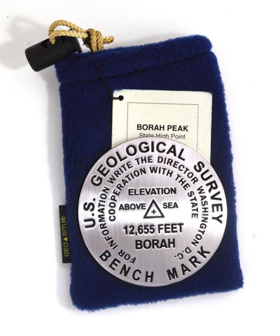
Borah Peak, Idaho paperweight
3 1/4 inch diameter
Cast in fine pewter
Felt backing
With soft fleece pouch
In clear-vinyl covered box
PLACE NAME: Borah Peak
ELEVATION: 12,655 ft.
COORDINATES: N44° 08 14 W113° 46 46
LOCATION: Idaho, USA
MARKERSLEUTH PHOTO CONTRIBUTOR: Ward Strang, 1998
Borah Peak is the highest peak of the Big Lost River Range and state of Idaho. It is a popular climb but should not be underestimated. Loose rock, sheer cliffs and steep slopes call for preparedness. Highpointer Club members recommend ice axes to arrest falls. The 1983 Borah Peak Earthquake (magnitude 7.3) is a reminder of the dynamic forces that shape the earths crust. The recognized elevation of Borah Peak is 12,662. The summit benchmark was set in 1965 and is stamped 12,655 feet.
- Product Number: GSU_PW_BORAH
- Reference Product Number: 2306070M
- ISBN: - None -
- Map format: - None -
- Map type: Accessories - Other Accessories
- Geographical region: United States
- Geographical subregion: Idaho


