
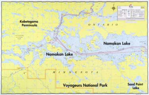
E-20: NAMAKAN LAKE WALL MAP
A detailed hydrographic map of Namakan Lake covering the area from Kabetogama and Sullivan Bay on the west to Hammer Bay on the east. (See map E-1 for Namakan Narrows entrance from Crane Lake.) Water depths, reefs, buoys, campsites, sections, portages, trails, and Voyageurs Park boundaries are shown
- Product Number: FSHR_E20
- Reference Product Number: - None -
- ISBN: - None -
- Unfolded (flat) Size: 22.25 inches high by 34.5 inches wide
- Map format: Wall
- Map type: Trade Maps - Fishing
- Geographical region: Canada,United States
- Geographical subregion: Minnesota,Ontario


