
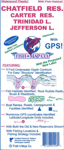
Chatfield, Carter Reservoir, Jefferson, South Platte River Fishing Map
Fish-N-Map Company underwater topography maps are printed on a waterproof, tear-resistant material and are folded to 9 x 4. When opened, each map is approximately 3 x 2 in size and is printed on both sides. These maps feature waterproof plastic paper; underwater depth contours; fish locations; latitude and longitude for GPS; often multiple lakes on one map; boat ramps; recreational facilities; and much more.
- Product Number: FNM_CHATF_18
- Reference Product Number: 2298660M
- ISBN: - None -
- Date of Publication: 6/1/2018
- Folded Size: 9.06 inches high by 3.94 inches wide
- Unfolded (flat) Size: 23.62 inches high by 35.83 inches wide
- Map format: Folded
- Map type: Trade Maps - Fishing
- Geographical region: United States
- Geographical subregion: Colorado


